1900s (20th Century) Maps of Gandy, Utah
Explore 8 historic maps of Gandy from the 1900s (20th Century). These maps offer a rare glimpse into what life looked like during the 1900s — showing old roads, neighborhoods, homes, and landmarks that have changed or disappeared over time.
Whether you're researching your family's past, planning a metal detecting trip, or studying how Gandy's landscape evolved across the 1900s, these high-resolution maps are a powerful tool for exploring the history of this region.
- Focus on a specific era: All maps on this page are from the 1900s, giving you a focused view of this time period.
- See what’s changed: Compare century-old streets, trails, and buildings to today's modern landscape using overlays and satellite layers.
- Research with precision: Use these maps for genealogy, historical research, land use analysis, or educational projects.
- View, download, or print: Maps are fully viewable online in high resolution, and can be downloaded or printed for your own records.
Start exploring Gandy's history through authentic maps from the 1900s. This is your window into the past.
Gandy, UT maps
(8)- 1908 Map of Fish Springs
 1908 Fish Springs1908 Print · USGSWestern Utah at the turn of the century is a land of remote mining camps and desert outposts. Trace family history and early industry at Utah Mine, Joy P.O., and the isolated Butson's Ranch near the Confusion Range.
 - 1910 Map of Fish Springs
 1910 Fish Springs1910 Print · USGSWestern Utah's high desert and isolated mining districts are mapped here in the early twentieth century, showing a landscape of remote ranching and rugged mineral claims. Local historians can trace family-named outposts like Meecham's Ranch and Thomas' Ranch or locate the Queen of Sheba Mine and Fish Springs.6 unique versions available
 - 1953 Map of Delta, 1969 Print
 1953 Delta1969 Print · USGSWest-central Utah in the early fifties shows a landscape of vast desert playas and rising mountain ranges. Genealogists and historians can trace rail sidings like Champlin Siding, local industry at the Tungsten Mill, and historic outposts such as Fort Deseret.3 unique versions available
 - 1958 Map of Delta
 1958 Delta1958 Print · USGSThe West Desert of Utah comes into sharp focus during the late 1950s, showing the intersection of military ranges, irrigation projects, and historical transit. You can trace the proximity of the Topaz Camp to Delta, or locate the Pony Express Monument and the ruins of Fort Deseret.
 - 1960 Map of Gandy, 1962 Print
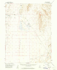 1960 Gandy1962 Print · USGSIn the arid borderlands of West-Central Utah during the early sixties, water and remote transit routes defined the local landscape. Genealogists and historians can trace the foundations of Gandy, the Smithville site, and scattered Graves along the Gandy Road.2 unique versions available
 - 1962 Map of Delta
 1962 Delta1962 Print · USGSWest Central Utah in the early sixties reveals a landscape of desert agriculture and military testing grounds. Researchers can trace the Union Pacific line through Delta or locate historic sites like the Pony Express Monument and Silver City.
 - 1981 Map of Tule Valley
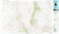 1981 Tule Valley1981 Print · USGSMillard County in the early eighties shows a remote Great Basin landscape of isolated springs and high limestone ridges. Trace early ranching and mineral sites from the Wheeler Amphitheater Mines to the settlements of Gandy and Eskdale.3 unique versions available
 - 1991 Map of Gandy
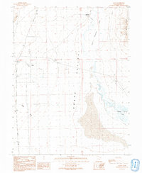 1991 Gandy1991 Print · USGSSnake Valley and the remote western border of Utah appear here as they were in the early nineties, focused on the small outposts of Gandy and Smithville. Researchers can trace old routes like Gandy Road to find isolated landmarks including a lonely Grave and the Bishop Springs Area.
End of results
Showing maps 1-8 of 8
Frequently asked questions
- What are the different types of historical maps available for Gandy?
- What is the oldest map of Gandy?
- Where can I purchase historical maps of Gandy for my home or office?
- Where can I download high-res historical maps of Gandy?
- Are there historical topographic maps available for Gandy?
- Is there historical aerial imagery available for Gandy?
- Where are historical maps of Gandy sourced from?