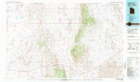
1981 Map of Tule Valley
USGS Topo · Published 1981About this map
Sevier Lake dominates the southeastern horizon of this Millard County landscape, marking a terminal point in the arid Great Basin topography. To the west, the House Range and Swasey Mountain form a massive limestone backbone between the Whirlwind Valley and the central Tule Valley. The map documents a sparsely settled frontier, where the small outposts of Gandy and Eskdale sit near the border of the Snake Valley. The land's character is defined by its water sources, from the isolated Tule Spring to the Confusion Hills Reservoir, which supported ranching and transit through the Confusion Range. In the House Range, the Wheeler Amphitheater Mines suggest the area's mineral interest, while the extensive system of knolls, ridges, and deserts like the Ferguson Desert illustrates the complex, basin-and-range geography before modern developments altered these remote corridors.
Find a feature on this map
41 named features on this map. Tap any name to fly to it.
Don’t see what you’re looking for? This feature index may not catch every label — zoom into the map to look around manually.
Map Details
Editions of this 1981 Tule Valley Map
3 editions found
Other maps of this area

1885 · Beaver
USGS Topo · 1:250,000

1885 · Sevier Desert
USGS Topo · 1:250,000

1908 · Fish Springs
USGS Topo · 1:250,000

1910 · Fish Springs
USGS Topo · 1:250,000

1949 · Garrison
USGS Topo · 1:62,500

1951 · Garrison
USGS Topo · 1:62,500

1953 · Topaz Mtn
USGS Topo · 1:62,500

1953 · Richfield
USGS Topo · 1:250,000

1953 · Delta
USGS Topo · 1:250,000

1956 · Lund
USGS Topo · 1:250,000