2000-2009 Maps of Oak City, Utah
Explore 2 historic maps of Oak City from 2000-2009. These maps offer a rare glimpse into what life looked like during the 2000s — showing old roads, neighborhoods, homes, and landmarks that have changed or disappeared over time.
Whether you're researching your family's past, planning a metal detecting trip, or studying how Oak City's landscape evolved across the 2000s, these high-resolution maps are a powerful tool for exploring the history of this region.
- Focus on a specific era: All maps on this page are from the 2000s, giving you a focused view of this time period.
- See what’s changed: Compare century-old streets, trails, and buildings to today's modern landscape using overlays and satellite layers.
- Research with precision: Use these maps for genealogy, historical research, land use analysis, or educational projects.
- View, download, or print: Maps are fully viewable online in high resolution, and can be downloaded or printed for your own records.
Start exploring Oak City's history through authentic maps from the 2000s. This is your window into the past.
Oak City, UT maps
(2)- 2001 Map of Oak City South, 2003 Print
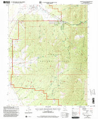 2001 Oak City South2003 Print · USGSMillard County, Utah, is shown here as it transitioned into the new millennium, where the Pahant Valley rises into the high peaks of the Fish Lake National Forest. Researchers can locate the Cem near Oak City, trace old mining activity at a Mine Shaft, or find secluded spots like Oak Creek Campground.
 - 2001 Map of Oak City North, 2003 Print
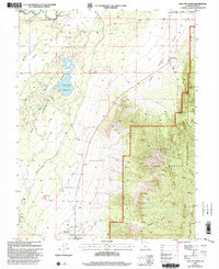 2001 Oak City North2003 Print · USGSOak City and the surrounding Millard County desert are captured here as they appeared at the turn of the millennium. Researchers can trace the Central Utah Canal and historic landmarks like Fool Creek Reservoir, Corral, and the Sand Dunes.
End of results
Showing maps 1-2 of 2
Top cities near Oak City
Frequently asked questions
- What are the different types of historical maps available for Oak City?
- What is the oldest map of Oak City?
- Where can I purchase historical maps of Oak City for my home or office?
- Where can I download high-res historical maps of Oak City?
- Are there historical topographic maps available for Oak City?
- Is there historical aerial imagery available for Oak City?
- Where are historical maps of Oak City sourced from?