1960s Maps of Scipio, Utah
Explore 2 historic maps of Scipio from the 1960s. These maps offer a rare glimpse into what life looked like during the 1960s — showing old roads, neighborhoods, homes, and landmarks that have changed or disappeared over time.
Whether you're researching your family's past, planning a metal detecting trip, or studying how Scipio's landscape evolved across the 1960s, these high-resolution maps are a powerful tool for exploring the history of this region.
- Focus on a specific era: All maps on this page are from the 1960s, giving you a focused view of this time period.
- See what’s changed: Compare century-old streets, trails, and buildings to today's modern landscape using overlays and satellite layers.
- Research with precision: Use these maps for genealogy, historical research, land use analysis, or educational projects.
- View, download, or print: Maps are fully viewable online in high resolution, and can be downloaded or printed for your own records.
Start exploring Scipio's history through authentic maps from the 1960s. This is your window into the past.
Scipio, UT maps
(2)- 1962 Map of Delta
 1962 Delta1962 Print · USGSWest Central Utah in the early sixties reveals a landscape of desert agriculture and military testing grounds. Researchers can trace the Union Pacific line through Delta or locate historic sites like the Pony Express Monument and Silver City.
 - 1969 Map of Scipio South, 1973 Print
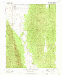 1969 Scipio South1973 Print · USGSThe high basins and mountain ranges of central Utah are captured here in the late sixties, centered on the ranching community of Scipio. Local historians can trace early land use through family-named landmarks like Sorensen Canyon and remote features such as Ralph Lund Spring or The Gap.2 unique versions available
End of results
Showing maps 1-2 of 2
Top cities near Scipio
Frequently asked questions
- What are the different types of historical maps available for Scipio?
- What is the oldest map of Scipio?
- Where can I purchase historical maps of Scipio for my home or office?
- Where can I download high-res historical maps of Scipio?
- Are there historical topographic maps available for Scipio?
- Is there historical aerial imagery available for Scipio?
- Where are historical maps of Scipio sourced from?