Old Maps of Scipio, Utah for Academic Research
Study the evolution of Scipio with 11 high-resolution historic maps. Whether you're teaching, researching, or modeling changes in land use, these maps provide essential visual documentation of urban, environmental, and geographic change.
- Analyze long-term change: Track patterns in development, transportation, and natural features.
- Ideal for environmental or urban studies: Support academic projects with primary historical map data.
- Use in the classroom or lab: Educators and researchers rely on these maps to bring historical context to life.
These maps are a powerful tool for teaching, research, and visualizing how Scipio has changed over the decades.
Scipio, UT maps
(11)- 1885 Map of Sevier Desert
 1885 Sevier Desert1885 Print · USGSMining districts and desert outposts across central Utah come to life in the mid-1880s as the railroad pushes through the canyon. Researchers can trace early industrial footprints at Silver City, locate the riverside settlement of Deseret, and follow the original Central Pacific Railroad line.5 unique versions available
 - 1952 Map of Scipio North, 1954 Print
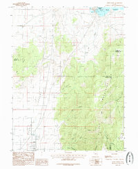
 1952 Scipio North1954 Print · USGSIn the early 1950s, the desert borderlands of Millard and Juab Counties were defined by the Sevier River's path and the rise of the high mountains. Trace the old Union Pacific corridor through Mills or locate family sites near Scipio and Dick & Dalton Flat.3 unique versions available
 - 1953 Map of Delta, 1969 Print
 1953 Delta1969 Print · USGSWest-central Utah in the early fifties shows a landscape of vast desert playas and rising mountain ranges. Genealogists and historians can trace rail sidings like Champlin Siding, local industry at the Tungsten Mill, and historic outposts such as Fort Deseret.3 unique versions available
 - 1958 Map of Delta
 1958 Delta1958 Print · USGSThe West Desert of Utah comes into sharp focus during the late 1950s, showing the intersection of military ranges, irrigation projects, and historical transit. You can trace the proximity of the Topaz Camp to Delta, or locate the Pony Express Monument and the ruins of Fort Deseret.
 - 1962 Map of Delta
 1962 Delta1962 Print · USGSWest Central Utah in the early sixties reveals a landscape of desert agriculture and military testing grounds. Researchers can trace the Union Pacific line through Delta or locate historic sites like the Pony Express Monument and Silver City.
 - 1969 Map of Scipio South, 1973 Print
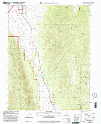
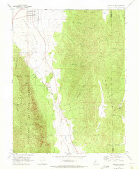 1969 Scipio South1973 Print · USGSThe high basins and mountain ranges of central Utah are captured here in the late sixties, centered on the ranching community of Scipio. Local historians can trace early land use through family-named landmarks like Sorensen Canyon and remote features such as Ralph Lund Spring or The Gap.2 unique versions available
 - 1985 Map of Scipio North
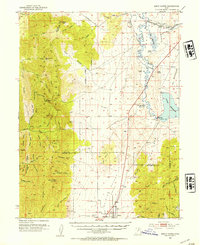
 1985 Scipio North1985 Print · USGSThe high desert of central Utah comes into focus in the mid-1980s, centered on the settlement of Scipio. Researchers can trace local landmarks like the Cem and the vast Sevier Bridge Reservoir or explore family-named terrain like Dick and Dalton Flat.
 - 1989 Map of Delta
 1989 Delta1989 Print · USGSThe Millard County desert in the late eighties reveals a complex irrigation system supporting agricultural life around Delta. Researchers can trace the layout of the Union Pacific Railroad, the historic site of Topaz Camp, and the volcanic features of Pahvant Butte.2 unique versions available
 - 2001 Map of Scipio South, 2003 Print
 2001 Scipio South2003 Print · USGSThe outskirts of Scipio at the turn of the 21st century reveal a landscape of high-desert valleys and steep National Forest canyons. Researchers can locate family-named landmarks like Billys Canyon, find the town Cem, or trace the path of Round Valley Creek.
 - 2023 Map of Scipio South, 2023 Print
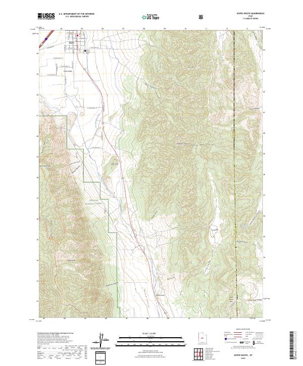 2023 Scipio South2023 Print · USGSThe high desert basins of Millard County are captured in this contemporary survey of the transition between the valley floor and the high peaks. Researchers can locate the Scipio Pioneer Cemetery or trace the drainages of Round Valley Creek through the Valley Mountains.
 - 2023 Map of Scipio North, 2023 Print
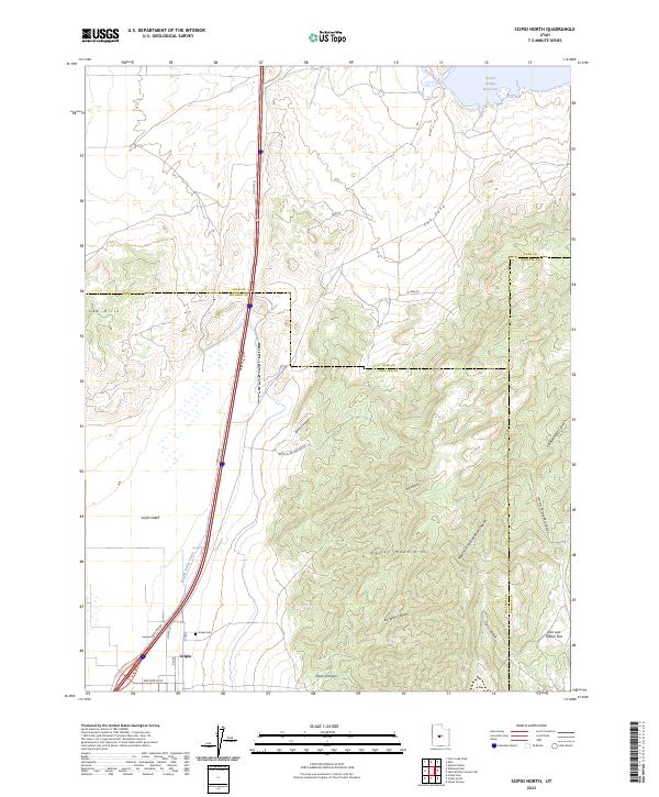 2023 Scipio North2023 Print · USGSScipio and the eastern Scipio Valley are captured in this recent survey during a period of modern agricultural and transit development. Genealogists and local historians can locate the Scipio Cem and trace old routes like OLD HWY 91 toward the Sevier Bridge Reservoir.
End of results
Showing maps 1-11 of 11
Top cities near Scipio
Frequently asked questions
- What are the different types of historical maps available for Scipio?
- What is the oldest map of Scipio?
- Where can I purchase historical maps of Scipio for my home or office?
- Where can I download high-res historical maps of Scipio?
- Are there historical topographic maps available for Scipio?
- Is there historical aerial imagery available for Scipio?
- Where are historical maps of Scipio sourced from?