
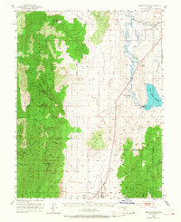
1952 Map of Scipio North
USGS Topo · Published 1954About this map
Scipio anchors the southern end of the Scipio Valley in this early 1950s survey of the central Utah desert. The landscape is defined by the stark transition from the high peaks of the Fishlake National Forest, including Fool Peak and Williams Peak, down to the irrigated corridor of the Sevier River. The Union Pacific line cuts through the northeast corner of the map, passing the small settlement of Mills and following the river's winding path toward the Sevier Reservoir. This era of water management is clearly visible at Yuba Dam and its adjacent spillway and gaging station, which regulated flows for the surrounding desert basins. Between the mountains and the river, numerous family-named canyons like Radford Canyon and Charley Canyon descend into the low hills, providing drainage for seasonal springs such as Mourning Dove Spring. The inclusion of small-scale features like the local Cemetery and various windmills near Dick & Dalton Flat offers a grounded view of mid-century ranching and agrarian life.
Find a feature on this map
69 named features on this map. Tap any name to fly to it.
Don’t see what you’re looking for? This feature index may not catch every label — zoom into the map to look around manually.
Map Details
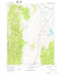
Editions of this 1952 Scipio North Map
3 editions found
Other maps of this area

1885 · Manti
USGS Topo · 1:250,000

1885 · Sevier Desert
USGS Topo · 1:250,000

1895 · Manti
USGS Topo · 1:250,000

1951 · Oak City
USGS Topo · 1:62,500

1951 · Nephi
USGS Topo · 1:62,500

1953 · Delta
USGS Topo · 1:250,000

1956 · Price
USGS Topo · 1:250,000

1958 · Delta
USGS Topo · 1:250,000

1960 · Price
USGS Topo · 1:250,000

1962 · Price
USGS Topo · 1:250,000