1980s Maps of Joseph, Utah
Explore 3 historic maps of Joseph from the 1980s. These maps offer a rare glimpse into what life looked like during the 1980s — showing old roads, neighborhoods, homes, and landmarks that have changed or disappeared over time.
Whether you're researching your family's past, planning a metal detecting trip, or studying how Joseph's landscape evolved across the 1980s, these high-resolution maps are a powerful tool for exploring the history of this region.
- Focus on a specific era: All maps on this page are from the 1980s, giving you a focused view of this time period.
- See what’s changed: Compare century-old streets, trails, and buildings to today's modern landscape using overlays and satellite layers.
- Research with precision: Use these maps for genealogy, historical research, land use analysis, or educational projects.
- View, download, or print: Maps are fully viewable online in high resolution, and can be downloaded or printed for your own records.
Start exploring Joseph's history through authentic maps from the 1980s. This is your window into the past.
Joseph, UT maps
(3)- 1980 Map of Antelope Range, 1981 Print
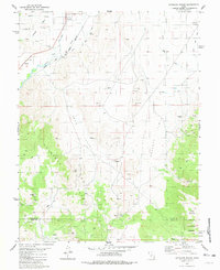 1980 Antelope Range1981 Print · USGSThe Sevier River valley in the early 1980s shows a landscape of rail-fed settlements and mountain mining. Trace family roots in Joseph and Sevier, or locate historic workings like the Antelope Mine and the irrigation network of Bertlesen Ditch.2 unique versions available
 - 1980 Map of Elsinore, 1981 Print
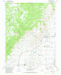 1980 Elsinore1981 Print · USGSThe Sevier River valley thrives as an irrigated agricultural corridor in the early 1980s, where rail and water define the landscape. Local historians can trace the paths of the Denver and Rio Grande Western through Elsinore and Joseph, or locate rural landmarks like the Rodeo Ground and regional Cemeteriers.
 - 1980 Map of Richfield, 1987 Print
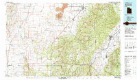 1980 Richfield1987 Print · USGSCentral Utah in the early eighties shows a landscape of volcanic fields and high mountain forests. Genealogists can trace family roots through the Sevier River valley in Richfield, Fillmore, and Monroe, or follow the Union Pacific rail lines.2 unique versions available
End of results
Showing maps 1-3 of 3
Top cities near Joseph
- Richfield historical maps
- Monroe historical maps
- Elsinore historical maps
- Annabella historical maps
- Kanosh historical maps
- Central Valley historical maps
See more
Frequently asked questions
- What are the different types of historical maps available for Joseph?
- What is the oldest map of Joseph?
- Where can I purchase historical maps of Joseph for my home or office?
- Where can I download high-res historical maps of Joseph?
- Are there historical topographic maps available for Joseph?
- Is there historical aerial imagery available for Joseph?
- Where are historical maps of Joseph sourced from?