1910s Maps of Naples, Utah
Explore 2 historic maps of Naples from the 1910s. These maps offer a rare glimpse into what life looked like during the 1910s — showing old roads, neighborhoods, homes, and landmarks that have changed or disappeared over time.
Whether you're researching your family's past, planning a metal detecting trip, or studying how Naples's landscape evolved across the 1910s, these high-resolution maps are a powerful tool for exploring the history of this region.
- Focus on a specific era: All maps on this page are from the 1910s, giving you a focused view of this time period.
- See what’s changed: Compare century-old streets, trails, and buildings to today's modern landscape using overlays and satellite layers.
- Research with precision: Use these maps for genealogy, historical research, land use analysis, or educational projects.
- View, download, or print: Maps are fully viewable online in high resolution, and can be downloaded or printed for your own records.
Start exploring Naples's history through authentic maps from the 1910s. This is your window into the past.
Naples, UT maps
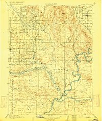
(2)- 1910 Map of Jensen
 1910 Jensen1910 Print · USGSThe Utah-Colorado borderlands come alive in the first decade of the twentieth century, showing the early development of the Uinta Basin. Genealogists and historians can locate early river crossings at the ferry sites near Jensen or trace the road to Dragon Stage Road.2 unique versions available
 - 1917 Map of Vernal
 1917 Vernal1917 Print · USGSThe Uinta Basin during the early twentieth century shows a landscape defined by river confluences and emerging irrigation benches. Genealogists can trace family names at Leota Ranch, explore the vicinity of Fort Duchesne, or locate rural schools like Bennett School.2 unique versions available
End of results
Showing maps 1-2 of 2
Top cities near Naples
Frequently asked questions
- What are the different types of historical maps available for Naples?
- What is the oldest map of Naples?
- Where can I purchase historical maps of Naples for my home or office?
- Where can I download high-res historical maps of Naples?
- Are there historical topographic maps available for Naples?
- Is there historical aerial imagery available for Naples?
- Where are historical maps of Naples sourced from?