1990s Maps of Aspen Grove, Utah
Explore 2 historic maps of Aspen Grove from the 1990s. These maps offer a rare glimpse into what life looked like during the 1990s — showing old roads, neighborhoods, homes, and landmarks that have changed or disappeared over time.
Whether you're researching your family's past, planning a metal detecting trip, or studying how Aspen Grove's landscape evolved across the 1990s, these high-resolution maps are a powerful tool for exploring the history of this region.
- Focus on a specific era: All maps on this page are from the 1990s, giving you a focused view of this time period.
- See what’s changed: Compare century-old streets, trails, and buildings to today's modern landscape using overlays and satellite layers.
- Research with precision: Use these maps for genealogy, historical research, land use analysis, or educational projects.
- View, download, or print: Maps are fully viewable online in high resolution, and can be downloaded or printed for your own records.
Start exploring Aspen Grove's history through authentic maps from the 1990s. This is your window into the past.
Aspen Grove, UT maps
(2)- 1993 Map of Aspen Grove, 1994 Print
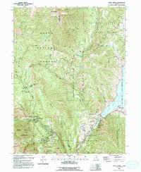 1993 Aspen Grove1994 Print · USGSMount Timpanogos and the Provo Canyon corridor appear here in the early nineties, showcasing a landscape of high-altitude recreation and wilderness. Trace the development of the Sundance Ski Area, the Aspen Grove complex, and the Old Railroad Grade.2 unique versions available
 - 1998 Map of Aspen Grove, 2000 Print
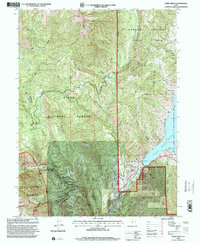 1998 Aspen Grove2000 Print · USGSThe Wasatch Range in the late 1990s reveals a high-country landscape balanced between wild wilderness and developed recreation. Researchers can trace the trails and roads around Mount Timpanogos, finding historic sites like The Theater in the Pines and landmarks such as Cascade Springs.
End of results
Showing maps 1-2 of 2
Top cities near Aspen Grove
- Provo historical maps
- Orem historical maps
- Sandy historical maps
- Lehi historical maps
- Draper historical maps
- Pleasant Grove historical maps
See more
Frequently asked questions
- What are the different types of historical maps available for Aspen Grove?
- What is the oldest map of Aspen Grove?
- Where can I purchase historical maps of Aspen Grove for my home or office?
- Where can I download high-res historical maps of Aspen Grove?
- Are there historical topographic maps available for Aspen Grove?
- Is there historical aerial imagery available for Aspen Grove?
- Where are historical maps of Aspen Grove sourced from?