1980s Maps of Lyman, Utah
Explore 2 historic maps of Lyman from the 1980s. These maps offer a rare glimpse into what life looked like during the 1980s — showing old roads, neighborhoods, homes, and landmarks that have changed or disappeared over time.
Whether you're researching your family's past, planning a metal detecting trip, or studying how Lyman's landscape evolved across the 1980s, these high-resolution maps are a powerful tool for exploring the history of this region.
- Focus on a specific era: All maps on this page are from the 1980s, giving you a focused view of this time period.
- See what’s changed: Compare century-old streets, trails, and buildings to today's modern landscape using overlays and satellite layers.
- Research with precision: Use these maps for genealogy, historical research, land use analysis, or educational projects.
- View, download, or print: Maps are fully viewable online in high resolution, and can be downloaded or printed for your own records.
Start exploring Lyman's history through authentic maps from the 1980s. This is your window into the past.
Lyman, UT maps
(2)- 1980 Map of Loa
 1980 Loa1980 Print · USGSCentral Utah's high plateaus and the Fremont River corridor are captured here during the 1980s, showcasing a landscape of high-elevation reservoirs and remote ranching outposts. Genealogists can trace family names and early settlements from Loa and Teasdale to the orchards of Fruita.2 unique versions available
 - 1985 Map of Lyman
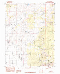 1985 Lyman1985 Print · USGSWayne County settlements and high desert water systems are captured in the mid-eighties as ranchers managed the eastern edge of the plateau. Local historians can trace early water infrastructure like the Highline Ditch and family-named landmarks including Tidwell Spring and Burnt Springs.
End of results
Showing maps 1-2 of 2
Top cities near Lyman
Frequently asked questions
- What are the different types of historical maps available for Lyman?
- What is the oldest map of Lyman?
- Where can I purchase historical maps of Lyman for my home or office?
- Where can I download high-res historical maps of Lyman?
- Are there historical topographic maps available for Lyman?
- Is there historical aerial imagery available for Lyman?
- Where are historical maps of Lyman sourced from?