1940s Maps of Addison County, Vermont
Explore 19 historic maps of Addison County from the 1940s. These maps offer a rare glimpse into what life looked like during the 1940s — showing old roads, neighborhoods, homes, and landmarks that have changed or disappeared over time.
Whether you're researching your family's past, planning a metal detecting trip, or studying how Addison County's landscape evolved across the 1940s, these high-resolution maps are a powerful tool for exploring the history of this region.
- Focus on a specific era: All maps on this page are from the 1940s, giving you a focused view of this time period.
- See what’s changed: Compare century-old streets, trails, and buildings to today's modern landscape using overlays and satellite layers.
- Research with precision: Use these maps for genealogy, historical research, land use analysis, or educational projects.
- View, download, or print: Maps are fully viewable online in high resolution, and can be downloaded or printed for your own records.
Start exploring Addison County's history through authentic maps from the 1940s. This is your window into the past.
Addison County, VT maps
(19)- 1941 Map of Willsboro
 1941 Willsboro1941 Print · USGSLake Champlain's shores in New York and Vermont are captured here just before the war, showing a landscape defined by lakefront landings and busy railroads. Trace the routes of the Delaware and Hudson and find local landmarks like Craterclub, Whallonsburg, and St Josephs Ch.2 unique versions available
 - 1943 Map of Willsboro
 1943 Willsboro1943 Print · USGSThe Lake Champlain shoreline in the early 1940s reveals a landscape of mountain-backed villages and vital cross-lake rail connections. Genealogists and researchers can trace local landmarks like St Josephs Ch, Lakeview Cem, and the path of the Delaware and Hudson railroad.3 unique versions available
 - 1943 Map of Cornwall
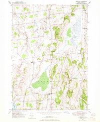
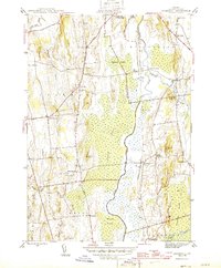 1943 Cornwall1943 Print · USGSMid-century Addison County is defined here by the winding waters of Otter Creek and the small agricultural villages of Cornwall and Salisbury. Trace the historic Rutland railroad line and locate local landmarks like Cady School or the Evergreen Cem.7 unique versions available
 - 1944 Map of Camels Hump
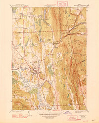
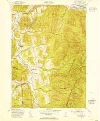
 1944 Camels Hump1944 Print · USGSThe Green Mountains at the height of the war era show a landscape defined by valley settlements and military expansion. You can trace the Central Vermont rail line through Bolton or find vanished rural schoolhouses like Ricker Sch and Phillips Sch.
 - 1944 Map of East Middlebury
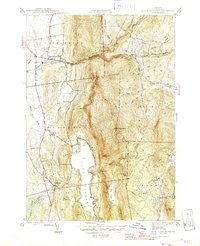
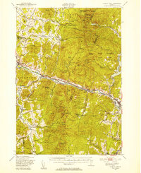
 1944 East Middlebury1944 Print · USGSThe Green Mountains in the mid-1940s reveal a landscape of deep timber and valley settlements. Genealogists and hikers can trace old family burial grounds at Prospect Cem and Galvin Cem, or follow the historic path of the Leicester Hollow Trl.6 unique versions available
 - 1944 Map of Burlington
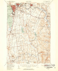
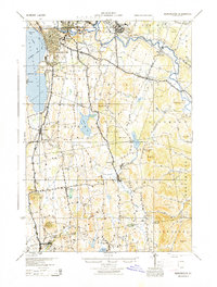 1944 Burlington1944 Print · USGSMid-century Burlington and its surrounding Lake Champlain shorelines are captured here at the height of the war years. Local historians can trace the Rutland Railroad through Shelburne or locate family sites near Prindle Corners and Fays Corners.2 unique versions available
 - 1945 Map of Port Henry, 1958 Print
 1945 Port Henry1958 Print · USGSMid-century life along the Vermont and New York border is centered on the waters of Lake Champlain and its historic defenses. Researchers can trace the ruins of Fort Crown Point or locate family roots at Gage Cemetery and Smith School.5 unique versions available
 - 1946 Map of Brandon
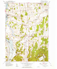
 1946 Brandon1946 Print · USGSMid-century Rutland County shows a classic Vermont landscape of valley settlements and rising mountain forests. Researchers can trace the path of the Rutland railroad or locate local landmarks like the Brandon State Sch and Sanderson Bridge.6 unique versions available
 - 1946 Map of East Middlebury
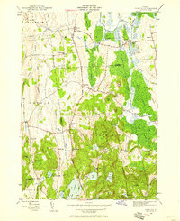
 1946 East Middlebury1946 Print · USGSAddison County in the mid-1940s reveals a landscape of mountain hamlets and forest reserves. Genealogists can locate family burial plots at Prospect Cem and Cooks Cem or trace the early community at Satans Kingdom.
 - 1946 Map of Sudbury, 1958 Print
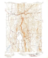
 1946 Sudbury1958 Print · USGSRutland County's rural landscape is captured here in the mid-1940s, showing a network of small schoolhouses and historic estates. Genealogists and local historians can trace the foundations of Hyde Manor or locate the many district schools like Seth Warner Sch and Webster Sch.2 unique versions available
 - 1947 Map of Port Henry
 1947 Port Henry1947 Print · USGSLake Champlain sits at the heart of this late 1940s survey of the New York and Vermont borderlands. Genealogists and local historians can trace legacy sites like the Fort St Frederic Ruins, the Rutland RR corridor, and a high density of country schools including Crane Sch and Smith Sch.2 unique versions available
 - 1948 Map of Sudbury
 1948 Sudbury1948 Print · USGSSudbury and the surrounding Rutland County townships are mapped here in the late 1940s, showing a landscape of rural schools and wetland agriculture. Genealogists and researchers can locate landmarks like Hyde Manor, the Seth Warner Sch, and the rail crossing at Leicester Junction.2 unique versions available
 - 1948 Map of Mount Philo, 1953 Print
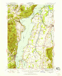
 1948 Mount Philo1953 Print · USGSThe Champlain Valley at the end of the 1940s reveals a landscape of upland pastures and valley farms. Genealogists and historians can trace old homesteads near Shelburne Falls, rural schoolhouses like New Palmer Sch, and the high points of Mount Philo.4 unique versions available
 - 1948 Map of Huntington, 1953 Print
 1948 Huntington1953 Print · USGSThe Huntington River valley and the heights of the Green Mountains are shown in the late 1940s before modern development. Hikers and historians can trace The Long Trail to remote camps like Gorham Lodge or find rural landmarks like Fiddock Sch.4 unique versions available
 - 1948 Map of Hinesburg, 1953 Print
 1948 Hinesburg1953 Print · USGSChittenden and Addison counties are shown during the late 1940s, a period when rural Vermont still relied heavily on local mills and quarries. Genealogists and hikers can trace the old homesteads around Rhode Island Corner or explore the heights of Mount Pritchard and Shaker Mountain.5 unique versions available
 - 1948 Map of Burlington, 1954 Print
 1948 Burlington1954 Print · USGSThe Lake Champlain shoreline and Winooski River valley are shown here just after the war, balancing urban growth with deep-rooted rural townships. Genealogists can locate family names and sites from St Michael College to remote landmarks like Prindle Corners and Fays Corner.4 unique versions available
 - 1948 Map of Camels Hump, 1954 Print
 1948 Camels Hump1954 Print · USGSThe Green Mountains of the late 1940s are defined by the Winooski River corridor and the high peaks of the range. Genealogists and local historians can trace the foundations of mountain life through Old Round Ch, the Machine Gun Sch, and the rail stops of the Central Vermont line.5 unique versions available
 - 1949 Map of Orwell
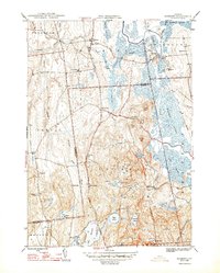
 1949 Orwell1949 Print · USGSMid-century Vermont agricultural life is captured here along the Lake Champlain shore and the vital Rutland Railroad line. Genealogists can trace local landmarks like Hough Crossing, the Larrabees Point Sta, and the Mountain View Cem.3 unique versions available
 - 1949 Map of Bridport, 1965 Print
 1949 Bridport1965 Print · USGSMid-century Addison County comes alive in this survey of the pastoral Champlain Valley landscape. Genealogists and researchers can trace family landmarks and rural infrastructure, including School No 6, St Genevieve Cem, and the historic crossroads at Cream Hill.4 unique versions available
End of results
Showing maps 1-19 of 19
Top cities of Addison County
- Middlebury historical maps
- Ferrisburgh historical maps
- Vergennes historical maps
- Bristol historical maps
- Starksboro historical maps
- New Haven historical maps
See more
Frequently asked questions
- What are the different types of historical maps available for Addison County?
- What is the oldest map of Addison County?
- Where can I purchase historical maps of Addison County for my home or office?
- Where can I download high-res historical maps of Addison County?
- Are there historical topographic maps available for Addison County?
- Is there historical aerial imagery available for Addison County?
- Where are historical maps of Addison County sourced from?