1970s Maps of Addison County, Vermont
Explore 7 historic maps of Addison County from the 1970s. These maps offer a rare glimpse into what life looked like during the 1970s — showing old roads, neighborhoods, homes, and landmarks that have changed or disappeared over time.
Whether you're researching your family's past, planning a metal detecting trip, or studying how Addison County's landscape evolved across the 1970s, these high-resolution maps are a powerful tool for exploring the history of this region.
- Focus on a specific era: All maps on this page are from the 1970s, giving you a focused view of this time period.
- See what’s changed: Compare century-old streets, trails, and buildings to today's modern landscape using overlays and satellite layers.
- Research with precision: Use these maps for genealogy, historical research, land use analysis, or educational projects.
- View, download, or print: Maps are fully viewable online in high resolution, and can be downloaded or printed for your own records.
Start exploring Addison County's history through authentic maps from the 1970s. This is your window into the past.
Addison County, VT maps
(7)- 1970 Map of Rochester, 1972 Print
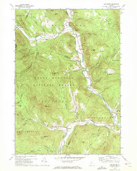 1970 Rochester1972 Print · USGSThe White River valley in the early seventies remains the heart of local life, with settlements like Rochester and Stockbridge anchored by the winding river. Researchers can trace family-named landmarks and rural outposts like Taleville, Jerusalem, and the St Dennis Ch across the mountain terrain.3 unique versions available
 - 1970 Map of Warren, 1972 Print
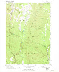 1970 Warren1972 Print · USGSThe Mad River valley and Northfield Mountains appear here in the early 1970s, showing a landscape of high forests and narrow valley settlements. Genealogists and hikers can trace the CENTRAL VERMONT rail line through East Granville or locate old burial sites like the Cem in East Warren.3 unique versions available
 - 1970 Map of Hancock, 1972 Print
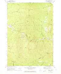
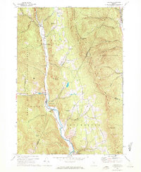 1970 Hancock1972 Print · USGSCentral Vermont in the early seventies shows a landscape of deep valleys and mountain passes along the White River. Researchers can trace the layout of mountain hamlets from Granville to Rochester, locating the Upper Branch Sch, Elmwood Cem, and the high Lookout Tower.3 unique versions available
 - 1970 Map of Lincoln, 1972 Print
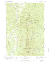
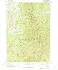 1970 Lincoln1972 Print · USGSVermont's Green Mountains appear in detail during the early 1970s, showing the high-elevation wilderness before modern development. Hikers and historians can trace the Long Trail past Mt Abraham and Lincoln Gap, or locate families near the Lee Cem and Lincoln Community Sch.2 unique versions available
 - 1970 Map of Mount Carmel, 1972 Print
 1970 Mount Carmel1972 Print · USGSThe Green Mountains in the early seventies are captured here in high detail at the meeting point of Rutland, Windsor, and Addison Counties. Researchers can locate remote burial sites like West Hill Cem and Wetmore Cem or trace trails past the Lookout Tower on Mount Carmel.
 - 1970 Map of Bread Loaf, 1973 Print
 1970 Bread Loaf1973 Print · USGSThe Green Mountains near Addison and Windsor counties come alive in the 1970s, showcasing a landscape defined by winter recreation and wilderness trails. Genealogists and researchers can trace the Long Trail past Bread Loaf and the Middlebury College Snow Bowl.3 unique versions available
 - 1971 Map of Mount Ellen, 1972 Print
 1971 Mount Ellen1972 Print · USGSThe Green Mountain heights of central Vermont come alive in the early seventies, showcasing the region's mid-century ski resort expansion. Trace the growth of Mad River Glen or locate family plots at Gore Cem and Little Ireland Cem.3 unique versions available
End of results
Showing maps 1-7 of 7
Top cities of Addison County
- Middlebury historical maps
- Ferrisburgh historical maps
- Vergennes historical maps
- Bristol historical maps
- Starksboro historical maps
- New Haven historical maps
See more
Frequently asked questions
- What are the different types of historical maps available for Addison County?
- What is the oldest map of Addison County?
- Where can I purchase historical maps of Addison County for my home or office?
- Where can I download high-res historical maps of Addison County?
- Are there historical topographic maps available for Addison County?
- Is there historical aerial imagery available for Addison County?
- Where are historical maps of Addison County sourced from?