1980s Maps of Addison County, Vermont
Explore 11 historic maps of Addison County from the 1980s. These maps offer a rare glimpse into what life looked like during the 1980s — showing old roads, neighborhoods, homes, and landmarks that have changed or disappeared over time.
Whether you're researching your family's past, planning a metal detecting trip, or studying how Addison County's landscape evolved across the 1980s, these high-resolution maps are a powerful tool for exploring the history of this region.
- Focus on a specific era: All maps on this page are from the 1980s, giving you a focused view of this time period.
- See what’s changed: Compare century-old streets, trails, and buildings to today's modern landscape using overlays and satellite layers.
- Research with precision: Use these maps for genealogy, historical research, land use analysis, or educational projects.
- View, download, or print: Maps are fully viewable online in high resolution, and can be downloaded or printed for your own records.
Start exploring Addison County's history through authentic maps from the 1980s. This is your window into the past.
Addison County, VT maps
(11)- 1980 Map of Willsboro
 1980 Willsboro1980 Print · USGSThe Lake Champlain shoreline at the edge of the Adirondacks was a bustling corridor of rail and water transport in the late twentieth century. Researchers can trace the Delaware and Hudson line between Willsboro and Essex, or locate family sites like Brookfield Cem and St Josephs Ch.
 - 1980 Map of Westport, 1981 Print
 1980 Westport1981 Print · USGSLake Champlain divides the New York Adirondacks from the Vermont plains in the early eighties, showing a landscape defined by water and rail. Researchers can trace family sites at Riverside Cem and Prospect Cem, or locate landmarks like Camp Dudley and the Delaware and Hudson railroad.3 unique versions available
 - 1980 Map of Roxbury, 1981 Print
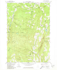 1980 Roxbury1981 Print · USGSRoxbury and South Northfield are captured here in the early 1980s, showcasing the high-elevation settlements and rail corridors of central Vermont. Genealogists can locate the First Settler Cem, the Rabbit Hollow Sch, and family-named terrain like Belcher Hill.2 unique versions available
 - 1980 Map of Port Henry, 1981 Print
 1980 Port Henry1981 Print · USGSLake Champlain's narrows were a hub of activity in the late twentieth century, balancing heavy industry with significant colonial heritage. Genealogists and historians can trace Fort St Frederic Ruins, family cemeteries like Spear Cem, and the path of the Delaware and Hudson railroad.
 - 1983 Map of Cornwall, 1990 Print
 1983 Cornwall1990 Print · USGSMid-century Addison County comes alive in this topographic study of the Otter Creek valley. Genealogists and historians can locate family landmarks like Evergreen Cem, the Rutland Railroad line, and several rural schoolhouses including Cady School and School No 2.
 - 1984 Map of Roxbury, 1991 Print
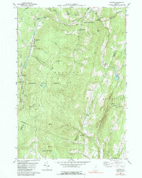 1984 Roxbury1991 Print · USGSCentral Vermont's mountain valleys are captured here in the early 1980s, centered on the rail-linked settlements of Roxbury and South Northfield. Researchers can trace old family names at the Orcutt Cem or locate the State Fish Hatchery and Rabbit Hollow Sch.
 - 1985 Map of Rutland, 1988 Print
 1985 Rutland1988 Print · USGSThe Upper Valley of the mid-1980s comes to life along the winding Connecticut River as it divides the Green Mountain and Granite states. Historians can trace the industrial rail hubs of White River Junction and the paths of the Appalachian Trail and Long Trail.
 - 1986 Map of Lake Champlain South
 1986 Lake Champlain South1986 Print · USGSIn the mid-1980s, the shores of Lake Champlain linked the Adirondack high peaks with the Vermont valley. Genealogists and researchers can trace the rail lines of the Delaware & Hudson RR or locate historic settlements like Mineville and Au Sable Forks.2 unique versions available
 - 1986 Map of Ticonderoga
 1986 Ticonderoga1986 Print · USGSThe Lake Champlain valley in the mid-eighties shows a landscape defined by Revolutionary War history and deep wilderness. Researchers can trace the Delaware and Hudson RR through the mountains or locate local landmarks like Fort Ticonderoga, St. Genevieve Cem, and the Ore Bed.
 - 1988 Map of Montpelier
 1988 Montpelier1988 Print · USGSThe area surrounding Vermont’s capital city appears here during the early 1940s, showing the vital rail-and-river network. Genealogists can trace family names across a dozen district schools and rural sites like Middlesex Center and the Talc Mine.2 unique versions available
 - 1989 Map of Ticonderoga
 1989 Ticonderoga1989 Print · USGSThe Champlain Valley and Adirondack foothills meet in the late eighties, documenting a historic borderland defined by mountain lakes and timber. Genealogists and historians can trace the paths of the Delaware and Hudson RR or locate the Hubbardton Battlefield State Historic Site.2 unique versions available
End of results
Showing maps 1-11 of 11
Top cities of Addison County
- Middlebury historical maps
- Ferrisburgh historical maps
- Vergennes historical maps
- Bristol historical maps
- Starksboro historical maps
- New Haven historical maps
See more
Frequently asked questions
- What are the different types of historical maps available for Addison County?
- What is the oldest map of Addison County?
- Where can I purchase historical maps of Addison County for my home or office?
- Where can I download high-res historical maps of Addison County?
- Are there historical topographic maps available for Addison County?
- Is there historical aerial imagery available for Addison County?
- Where are historical maps of Addison County sourced from?