1960s Maps of Manchester, Vermont
Explore 5 historic maps of Manchester from the 1960s. These maps offer a rare glimpse into what life looked like during the 1960s — showing old roads, neighborhoods, homes, and landmarks that have changed or disappeared over time.
Whether you're researching your family's past, planning a metal detecting trip, or studying how Manchester's landscape evolved across the 1960s, these high-resolution maps are a powerful tool for exploring the history of this region.
- Focus on a specific era: All maps on this page are from the 1960s, giving you a focused view of this time period.
- See what’s changed: Compare century-old streets, trails, and buildings to today's modern landscape using overlays and satellite layers.
- Research with precision: Use these maps for genealogy, historical research, land use analysis, or educational projects.
- View, download, or print: Maps are fully viewable online in high resolution, and can be downloaded or printed for your own records.
Start exploring Manchester's history through authentic maps from the 1960s. This is your window into the past.
Manchester, VT maps
(5)- 1964 Map of Glens Falls
 1964 Glens Falls1964 Print · USGSThe tri-state borderlands of New York, Vermont, and New Hampshire appear here in the mid-1960s. Researchers can trace the rail routes of the Rutland RR and find historic sites like Ticonderoga and Saratoga National Historical Park.
 - 1967 Map of Arlington, 1971 Print
 1967 Arlington1971 Print · USGSArlington and its surrounding hamlets are captured in the late sixties as the valley economy balanced river-side industry and mountain forestry. Researchers can trace the layout of small settlements like Chiselville and Kansas or locate family sites near Evergreen Cem and Fisher Sch.2 unique versions available
 - 1967 Map of West Rupert, 1972 Print
 1967 West Rupert1972 Print · USGSBennington County’s highlands are captured here during the late sixties, showcasing a landscape of steep hollows and mountain forests. Researchers can trace family names across Shatterack Mountain or locate early settlements like West Sandgate and Beartown.
 - 1968 Map of Sunderland, 1972 Print
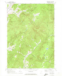
 1968 Sunderland1972 Print · USGSBennington County in the late sixties reveals a landscape where valley farming in Sunderland meets the high wilderness of the Green Mountains. Hikers and historians can trace the Appalachian Trail through remote settlements like East Kansas and Fayville.
 - 1968 Map of Manchester, 1973 Print
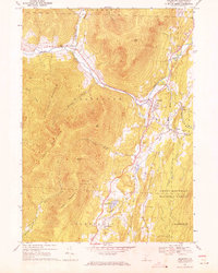
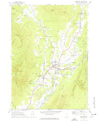 1968 Manchester1973 Print · USGSManchester and the Batten Kill valley appear here in the late sixties, showing a landscape defined by historic village centers and mountain tourism. Genealogists and researchers can locate Burr-Barton Seminary, the Vermont Railway, and several family burial sites like South Village Cem.4 unique versions available
End of results
Showing maps 1-5 of 5
Top cities near Manchester
- Hoosick historical maps
- Granville historical maps
- Manchester historical maps
- Shaftsbury historical maps
- White Creek historical maps
- Salem historical maps
See more
Top neighborhoods of Manchester
- Beartown historical maps
- Barnumville historical maps
- Haines Manor historical maps
- Bourne Brook historical maps
- Manchester Depot historical maps
- Mountain View Estates historical maps
See more
Frequently asked questions
- What are the different types of historical maps available for Manchester?
- What is the oldest map of Manchester?
- Where can I purchase historical maps of Manchester for my home or office?
- Where can I download high-res historical maps of Manchester?
- Are there historical topographic maps available for Manchester?
- Is there historical aerial imagery available for Manchester?
- Where are historical maps of Manchester sourced from?