1930s Maps of Grand Isle, Vermont
Explore 2 historic maps of Grand Isle from the 1930s. These maps offer a rare glimpse into what life looked like during the 1930s — showing old roads, neighborhoods, homes, and landmarks that have changed or disappeared over time.
Whether you're researching your family's past, planning a metal detecting trip, or studying how Grand Isle's landscape evolved across the 1930s, these high-resolution maps are a powerful tool for exploring the history of this region.
- Focus on a specific era: All maps on this page are from the 1930s, giving you a focused view of this time period.
- See what’s changed: Compare century-old streets, trails, and buildings to today's modern landscape using overlays and satellite layers.
- Research with precision: Use these maps for genealogy, historical research, land use analysis, or educational projects.
- View, download, or print: Maps are fully viewable online in high resolution, and can be downloaded or printed for your own records.
Start exploring Grand Isle's history through authentic maps from the 1930s. This is your window into the past.
Grand Isle, VT maps
(2)- 1939 Map of Rouses Point
 1939 Rouses Point1939 Print · USGSThe northern reaches of Lake Champlain and the Canadian border come alive in this pre-war survey of the New York-Vermont frontier. Genealogists and historians can trace rail-and-water connections through Rouses Point, locate family landmarks like Doane Cem, and explore the grounds of Fort Montgomery.4 unique versions available
 - 1939 Map of Plattsburg
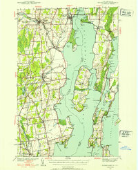
 1939 Plattsburg1939 Print · USGSLake Champlain was a vital corridor for rail and military activity just before the second World War. Genealogists and historians can trace the Plattsburg Barracks, the Rutland Railroad on Grand Isle, and landmarks like Hotel Champlain.
End of results
Showing maps 1-2 of 2
Top cities near Grand Isle
- Burlington historical maps
- South Burlington historical maps
- Plattsburgh historical maps
- Colchester historical maps
- Plattsburgh historical maps
- Essex historical maps
See more
Top neighborhoods of Grand Isle
- Adams Landing historical maps
- Gordon Landing historical maps
- Grand Isle Station historical maps
- Pearl historical maps
Frequently asked questions
- What are the different types of historical maps available for Grand Isle?
- What is the oldest map of Grand Isle?
- Where can I purchase historical maps of Grand Isle for my home or office?
- Where can I download high-res historical maps of Grand Isle?
- Are there historical topographic maps available for Grand Isle?
- Is there historical aerial imagery available for Grand Isle?
- Where are historical maps of Grand Isle sourced from?