1980s Maps of Vershire, Vermont
Explore 7 historic maps of Vershire from the 1980s. These maps offer a rare glimpse into what life looked like during the 1980s — showing old roads, neighborhoods, homes, and landmarks that have changed or disappeared over time.
Whether you're researching your family's past, planning a metal detecting trip, or studying how Vershire's landscape evolved across the 1980s, these high-resolution maps are a powerful tool for exploring the history of this region.
- Focus on a specific era: All maps on this page are from the 1980s, giving you a focused view of this time period.
- See what’s changed: Compare century-old streets, trails, and buildings to today's modern landscape using overlays and satellite layers.
- Research with precision: Use these maps for genealogy, historical research, land use analysis, or educational projects.
- View, download, or print: Maps are fully viewable online in high resolution, and can be downloaded or printed for your own records.
Start exploring Vershire's history through authentic maps from the 1980s. This is your window into the past.
Vershire, VT maps
(7)- 1981 Map of West Topsham
 1981 West Topsham1981 Print · USGSThe hill country of Orange and Topsham in the early 1980s reveals a landscape of isolated valley settlements and high ridges. Genealogists can trace family names at Hutchinson Cem or locate old sites like Union No 36 Sch and the mines on Pike Hill.
 - 1981 Map of Washington
 1981 Washington1981 Print · USGSCentral Vermont's rural landscape is captured here in the early eighties, showcasing the intersection of small upland hamlets and managed timberlands. Genealogists and local historians can locate several family cemeteries such as Fish Cem and Clough Cem, or trace the winding roads connecting Washington to Kennedy Corners.2 unique versions available
 - 1981 Map of Vershire
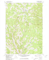
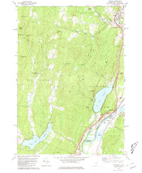
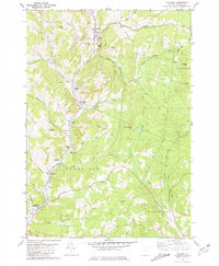
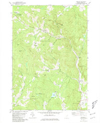 1981 Vershire1981 Print · USGSOrange County's hill country is captured in the early 1980s, showcasing a landscape of dispersed hamlets and mountain farmsteads. Genealogists and historians can trace old property access via Old City Road and locate rural landmarks such as Vershire Center and the Mountain Sch.4 unique versions available
 - 1981 Map of Fairlee
 1981 Fairlee1981 Print · USGSThe Connecticut River valley in the early eighties shows a landscape of lakeside leisure and transit corridors. Researchers can trace the Boston and Maine rail line, locate St Martins Chapel, and find local landmarks like the Drive-in Theater and Bear Ridge Raceway.3 unique versions available
 - 1981 Map of Chelsea
 1981 Chelsea1981 Print · USGSOrange County, Vermont, maintains its traditional river-valley character in this early 1980s survey of the White River highlands. Researchers can trace historic timber spans like the Larkin Covered Bridge and locate numerous family burial grounds, including Lincoln Cem and Durkee Cem.3 unique versions available
 - 1985 Map of Rutland, 1988 Print
 1985 Rutland1988 Print · USGSThe Upper Valley of the mid-1980s comes to life along the winding Connecticut River as it divides the Green Mountain and Granite states. Historians can trace the industrial rail hubs of White River Junction and the paths of the Appalachian Trail and Long Trail.
 - 1988 Map of Montpelier
 1988 Montpelier1988 Print · USGSThe area surrounding Vermont’s capital city appears here during the early 1940s, showing the vital rail-and-river network. Genealogists can trace family names across a dozen district schools and rural sites like Middlesex Center and the Talc Mine.2 unique versions available
End of results
Showing maps 1-7 of 7
Top cities near Vershire
- Hanover historical maps
- Barre historical maps
- Randolph historical maps
- Williamstown historical maps
- Norwich historical maps
- Berlin historical maps
See more
Top neighborhoods of Vershire
- Beanville historical maps
- Brimstone Corner historical maps
- Mill Village historical maps
- South Vershire historical maps
- Vershire Heights historical maps
- Vershire Center historical maps
Frequently asked questions
- What are the different types of historical maps available for Vershire?
- What is the oldest map of Vershire?
- Where can I purchase historical maps of Vershire for my home or office?
- Where can I download high-res historical maps of Vershire?
- Are there historical topographic maps available for Vershire?
- Is there historical aerial imagery available for Vershire?
- Where are historical maps of Vershire sourced from?