1900s (20th Century) Maps of Benson, Vermont
Explore 21 historic maps of Benson from the 1900s (20th Century). These maps offer a rare glimpse into what life looked like during the 1900s — showing old roads, neighborhoods, homes, and landmarks that have changed or disappeared over time.
Whether you're researching your family's past, planning a metal detecting trip, or studying how Benson's landscape evolved across the 1900s, these high-resolution maps are a powerful tool for exploring the history of this region.
- Focus on a specific era: All maps on this page are from the 1900s, giving you a focused view of this time period.
- See what’s changed: Compare century-old streets, trails, and buildings to today's modern landscape using overlays and satellite layers.
- Research with precision: Use these maps for genealogy, historical research, land use analysis, or educational projects.
- View, download, or print: Maps are fully viewable online in high resolution, and can be downloaded or printed for your own records.
Start exploring Benson's history through authentic maps from the 1900s. This is your window into the past.
Benson, VT maps
(21)- 1902 Map of Whitehall
 1902 Whitehall1902 Print · USGSThe borderlands of New York and Vermont at the turn of the century show a region defined by the Champlain Canal and the Delaware and Hudson R.R. maritime and rail networks. Genealogists and historians can trace the early layout of Whitehall, small lakeside landings like Snody Dock, and the winding Poultney River.10 unique versions available
 - 1902 Map of Ticonderoga
 1902 Ticonderoga1902 Print · USGSThe Champlain Valley at the start of the twentieth century is captured here in the borderlands of New York and Vermont. Researchers can trace the military grounds of Fort Ticonderoga, identify operations at the Iron Mine, and locate rural stations like Burdick Crossing.11 unique versions available
 - 1902 Map of Brandon, 1956 Print
 1902 Brandon1956 Print · USGSCentral Vermont at the turn of the century shows a landscape defined by the Otter Creek valley and the bustling Rutland Railroad. Genealogists and historians can trace old homesteads and rail sidings at Leicester Junction, Hyde Manor, and Forestdale.2 unique versions available
 - 1904 Map of Brandon
 1904 Brandon1904 Print · USGSCentral Vermont at the opening of the century shows a landscape defined by the Rutland R.R. and the winding Otter Creek. Genealogists and researchers can trace local landmarks from Hyde Manor to the mills of Forestdale and the rail hub at Leicester Junction.5 unique versions available
 - 1920 Map of Brandon
 1920 Brandon1920 Print · USGSVermont's western foothills and the Otter Creek valley are shown in detail during the early twentieth century. Researchers can trace the Rutland R. R. through Leicester Junction and find historic landmarks like Hyde Manor and the Lime Kiln.
 - 1927 Map of Orwell
 1927 Orwell1927 Print · USGSMid-century Addison County reveals a landscape shaped by the Rutland Railroad and the Lake Champlain shoreline. Genealogists and local historians can trace family-named sites from Larrabees Point to Orwell and locate rural landmarks like Hough Crossing School.
 - 1944 Map of Bomoseen
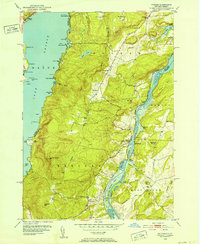
 1944 Bomoseen1944 Print · USGSLake Bomoseen and the surrounding hills of Rutland County are captured in the mid-1940s during a period of transition between traditional farming and lakefront recreation. Researchers can locate rural landmarks like Turnpike Sch, East Hubbardton Cem, and the village of West Castleton.5 unique versions available
 - 1946 Map of Sudbury, 1958 Print
 1946 Sudbury1958 Print · USGSRutland County's rural landscape is captured here in the mid-1940s, showing a network of small schoolhouses and historic estates. Genealogists and local historians can trace the foundations of Hyde Manor or locate the many district schools like Seth Warner Sch and Webster Sch.2 unique versions available
 - 1946 Map of Benson, 1972 Print
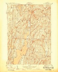
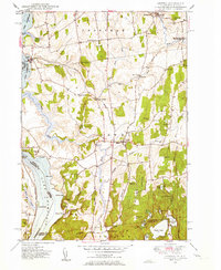
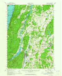
 1946 Benson1972 Print · USGSThe rural borderlands of Rutland County come into focus just after World War II, showing a landscape of scattered schools and family farms. Researchers can trace local lineage through Carter Street Cem and identify old schoolhouse locations like Howard Hill Sch and Stony Point Sch.3 unique versions available
 - 1948 Map of Benson
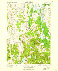
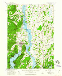
 1948 Benson1948 Print · USGSRutland County's lakeside and river valleys are captured here in the late 1940s, showing a landscape defined by small farms and regional rail lines. Researchers can trace family history through numerous rural landmarks like Fair View Cem, Aiken Sch, and the Delaware and Hudson RR.2 unique versions available
 - 1948 Map of Sudbury
 1948 Sudbury1948 Print · USGSSudbury and the surrounding Rutland County townships are mapped here in the late 1940s, showing a landscape of rural schools and wetland agriculture. Genealogists and researchers can locate landmarks like Hyde Manor, the Seth Warner Sch, and the rail crossing at Leicester Junction.2 unique versions available
 - 1949 Map of Orwell
 1949 Orwell1949 Print · USGSMid-century Vermont agricultural life is captured here along the Lake Champlain shore and the vital Rutland Railroad line. Genealogists can trace local landmarks like Hough Crossing, the Larrabees Point Sta, and the Mountain View Cem.3 unique versions available
 - 1950 Map of Glens Falls
 1950 Glens Falls1950 Print · USGSThe Adirondacks and the Green Mountains meet in this mid-century survey of the New York and Vermont borderlands. Researchers can trace the industrial rail corridors of the Rutland RR and Delaware & Hudson RR connecting Glens Falls, Rutland, and the shores of Lake George.
 - 1950 Map of Putnam, 1952 Print
 1950 Putnam1952 Print · USGSNew York’s Adirondack foothills meet the Vermont border at mid-century, spanning the high ground between two major lakes. Genealogists and historians can trace the lakeside settlements of Putnam and Dresden or find old family sites like Gilletts Cem and the Swale Sch.5 unique versions available
 - 1950 Map of Ticonderoga, 1960 Print
 1950 Ticonderoga1960 Print · USGSThe Champlain Valley around the Vermont and New York border comes into focus just after the war, showing a landscape defined by its historic forts and rail lines. Genealogists and historians can trace family-named landmarks like Burdick Crossing, local schools such as Lake Sch, and old cemeteries including Lakeview Cem.3 unique versions available
 - 1950 Map of Whitehall, 1960 Print
 1950 Whitehall1960 Print · USGSMid-century Washington County and the Vermont border are revealed here at a time when the lake-and-rail economy remained central. Genealogists and historians can trace family plots at Dresden Cem, locate the William Miller Chapel, or find the old Hooper Mine and Carver Falls Dam.2 unique versions available
 - 1956 Map of Glens Falls, 1968 Print
 1956 Glens Falls1968 Print · USGSUpper New York and the Vermont mountains are captured here in the mid-fifties, showing the rugged rail-and-river network of the Northeast. Researchers can trace the paths of the Delaware and Hudson RR and Rutland RR as they wind through valley towns like Poultney and Whitehall.3 unique versions available
 - 1959 Map of Glens Falls
 1959 Glens Falls1959 Print · USGSUpper New York and Vermont are captured here during the late 1950s, a period of transition for these mountain communities. Researchers can trace the legacy of the region's river-and-rail economy through landmarks like Lake George, Saratoga Springs, and Killington Peak.2 unique versions available
 - 1964 Map of Glens Falls
 1964 Glens Falls1964 Print · USGSThe tri-state borderlands of New York, Vermont, and New Hampshire appear here in the mid-1960s. Researchers can trace the rail routes of the Rutland RR and find historic sites like Ticonderoga and Saratoga National Historical Park.
 - 1986 Map of Ticonderoga
 1986 Ticonderoga1986 Print · USGSThe Lake Champlain valley in the mid-eighties shows a landscape defined by Revolutionary War history and deep wilderness. Researchers can trace the Delaware and Hudson RR through the mountains or locate local landmarks like Fort Ticonderoga, St. Genevieve Cem, and the Ore Bed.
 - 1989 Map of Ticonderoga
 1989 Ticonderoga1989 Print · USGSThe Champlain Valley and Adirondack foothills meet in the late eighties, documenting a historic borderland defined by mountain lakes and timber. Genealogists and historians can trace the paths of the Delaware and Hudson RR or locate the Hubbardton Battlefield State Historic Site.2 unique versions available
End of results
Showing maps 1-21 of 21
Top cities near Benson
- Granville historical maps
- Fort Ann historical maps
- Ticonderoga historical maps
- Brandon historical maps
- Whitehall historical maps
- Poultney historical maps
See more
Top neighborhoods of Benson
- Stacy Crossroads historical maps
- Benson Landing historical maps
- Benson Village Historic District historical maps
Frequently asked questions
- What are the different types of historical maps available for Benson?
- What is the oldest map of Benson?
- Where can I purchase historical maps of Benson for my home or office?
- Where can I download high-res historical maps of Benson?
- Are there historical topographic maps available for Benson?
- Is there historical aerial imagery available for Benson?
- Where are historical maps of Benson sourced from?