1980s Maps of East Montpelier, Vermont
Explore 3 historic maps of East Montpelier from the 1980s. These maps offer a rare glimpse into what life looked like during the 1980s — showing old roads, neighborhoods, homes, and landmarks that have changed or disappeared over time.
Whether you're researching your family's past, planning a metal detecting trip, or studying how East Montpelier's landscape evolved across the 1980s, these high-resolution maps are a powerful tool for exploring the history of this region.
- Focus on a specific era: All maps on this page are from the 1980s, giving you a focused view of this time period.
- See what’s changed: Compare century-old streets, trails, and buildings to today's modern landscape using overlays and satellite layers.
- Research with precision: Use these maps for genealogy, historical research, land use analysis, or educational projects.
- View, download, or print: Maps are fully viewable online in high resolution, and can be downloaded or printed for your own records.
Start exploring East Montpelier's history through authentic maps from the 1980s. This is your window into the past.
East Montpelier, VT maps
(3)- 1981 Map of Barre East
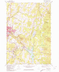 1981 Barre East1981 Print · USGSThe granite industry of central Vermont is captured here in the early 1980s, centered on the massive extraction sites of Millstone Hill. Researchers can trace the layout of quarrying villages like Websterville and Graniteville or locate family sites near Hope Cem and Wilson Cem.2 unique versions available
 - 1986 Map of Plainfield, 1987 Print
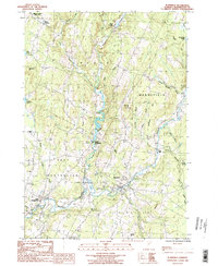 1986 Plainfield1987 Print · USGSUpper Washington County in the mid-1980s shows a landscape of river-valley villages and high-pasture townships. Researchers can trace the Old RR Grade through East Montpelier or locate family history at the Covered Bridge and small cemeteries near East Calais.
 - 1988 Map of Montpelier
 1988 Montpelier1988 Print · USGSThe area surrounding Vermont’s capital city appears here during the early 1940s, showing the vital rail-and-river network. Genealogists can trace family names across a dozen district schools and rural sites like Middlesex Center and the Talc Mine.2 unique versions available
End of results
Showing maps 1-3 of 3
Top cities near East Montpelier
- Barre historical maps
- Montpelier historical maps
- Northfield historical maps
- Waterbury historical maps
- Stowe historical maps
- Williamstown historical maps
See more
Top neighborhoods of East Montpelier
Frequently asked questions
- What are the different types of historical maps available for East Montpelier?
- What is the oldest map of East Montpelier?
- Where can I purchase historical maps of East Montpelier for my home or office?
- Where can I download high-res historical maps of East Montpelier?
- Are there historical topographic maps available for East Montpelier?
- Is there historical aerial imagery available for East Montpelier?
- Where are historical maps of East Montpelier sourced from?