1800s (19th Century) Maps of Windham County, Vermont
Explore 20 historic maps of Windham County from the 1800s (19th Century). These maps offer a rare glimpse into what life looked like during the 1800s — showing old roads, neighborhoods, homes, and landmarks that have changed or disappeared over time.
Whether you're researching your family's past, planning a metal detecting trip, or studying how Windham County's landscape evolved across the 1800s, these high-resolution maps are a powerful tool for exploring the history of this region.
- Focus on a specific era: All maps on this page are from the 1800s, giving you a focused view of this time period.
- See what’s changed: Compare century-old streets, trails, and buildings to today's modern landscape using overlays and satellite layers.
- Research with precision: Use these maps for genealogy, historical research, land use analysis, or educational projects.
- View, download, or print: Maps are fully viewable online in high resolution, and can be downloaded or printed for your own records.
Start exploring Windham County's history through authentic maps from the 1800s. This is your window into the past.
Windham County, VT maps
(20)- 1886 Map of Hawley
 1886 Hawley1886 Print · USGSThe northern Berkshires and Vermont border are captured in the late 1800s as railroads began to pierce the highlands. Trace the engineering of the Hoosac Tunnel or locate old settlements like Monroe Bridge and Buckland Four Corners.
 - 1887 Map of Warwick
 1887 Warwick1887 Print · USGSUpper Massachusetts and the New Hampshire border at the close of the nineteenth century reveal a landscape of river-powered industry and rail-connected villages. Researchers can trace the path of the Fitchburg R.R. through Millers Falls or locate early river crossings like Munns Ferry.
 - 1889 Map of Warwick
 1889 Warwick1889 Print · USGSFranklin County in the late 1880s was defined by its busy rail junctions and river valleys. Genealogists and historians can trace the development of Orange and Northfield, or locate vanished rail stops like Gill Station and Wendell Depot along the Fitchburg Railroad.
 - 1889 Map of Wilmington
 1889 Wilmington1889 Print · USGSSouthern Vermont in the late nineteenth century was a landscape of steep mountain ridges and river-driven commerce. Genealogists can trace family names and small hamlets like Heartwellville, Davis Bridge, and the Hoosac Tunnel and Wilmington R.R.7 unique versions available
 - 1890 Map of Hawley
 1890 Hawley1890 Print · USGSFranklin County and the Vermont borderlands are shown here in the 1880s as the railroad era transformed the Deerfield Valley. Trace the path of the Fitchburg Railroad through the Hoosac Tunnel or find old roads in Hawley and Ashfield.
 - 1890 Map of Greenfield
 1890 Greenfield1890 Print · USGSFranklin County's industrial and rail corridors are captured in the late nineteenth century as the river valleys pulsed with water-powered manufacturing. Genealogists and historians can trace the foundations of Turners Falls, the layout of Lake Pleasant Camp Ground, and the rail connections at Conway Depot.
 - 1891 Map of Wilmington
 1891 Wilmington1891 Print · USGSSouthern Vermont in the early 1890s was a landscape of mountain hamlets and river-valley industry. You can trace the Hoosac Tunnel and Wilmington R.R. or locate historic settlements like Readsboro Falls, Jacksonville, and West Dover.
 - 1891 Map of Brattleboro
 1891 Brattleboro1891 Print · USGSSouthern Vermont’s industrial and rail corridors are captured here in the late nineteenth century as the region transitioned into a hub for trade. Genealogists and local historians can trace the early rail stops at Putney Station, Dummerston Station, and the rural layout of Guilford Center.
 - 1893 Map of Wallingford
 1893 Wallingford1893 Print · USGSThe Green Mountains of Rutland County appear in the 1890s as a landscape of busy rail corridors and upland villages. Genealogists can trace family names and small industrial hubs like Mechanicsville, Cuttingsville, and the remote mountain settlement of Griffith.8 unique versions available
 - 1893 Map of Brattleboro
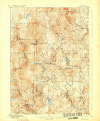
 1893 Brattleboro1893 Print · USGSWindham County at the close of the nineteenth century reveals a landscape defined by its river-valley railroads and hill-country settlements. Genealogists and historians can trace defunct rail stops like Williamsville Station and Dummerston Station or locate family landmarks near Ginseng Hill and Hinesburg.7 unique versions available
 - 1894 Map of Greenfield
 1894 Greenfield1894 Print · USGSFranklin County's industrial river valleys are captured here in the late 19th century as rail lines and water power drove local growth. Genealogists and historians can trace the foundations of Turner Falls, the transit hub at Cheapside, and the historic village of Deerfield.10 unique versions available
 - 1894 Map of Hawley
 1894 Hawley1894 Print · USGSThe northern Berkshires in the late nineteenth century are defined by the Deerfield River and the legendary Hoosac Tunnel rail route. Researchers can trace old upland hamlets like Spruce Corner, locate riverside settlements such as Monroe Bridge, and study the early rail network through Zoar.8 unique versions available
 - 1894 Map of Londonderry
 1894 Londonderry1894 Print · USGSSouthern Vermont in the 1890s was a land of high ridges and isolated mountain hollows. Researchers can trace the early layout of South Londonderry and find now-quiet settlements like Bucketville and Wardsboro Center.
 - 1894 Map of Warwick
 1894 Warwick1894 Print · USGSNorthern Massachusetts and New Hampshire borderlands are captured here in the late nineteenth century, showing a landscape shaped by the Millers River. Researchers can trace the path of the Central Vermont Railroad and find early settlements like Wendell Depot and Northfield.6 unique versions available
 - 1894 Map of Equinox, 1964 Print
 1894 Equinox1964 Print · USGSBennington County's river valleys and mountain peaks are captured here in the late nineteenth century as timber and rail defined the local economy. Genealogists and historians can trace the early layouts of Arlington, Manchester, and vanished settlements like Kansas or Fayville.2 unique versions available
 - 1896 Map of Equinox
 1896 Equinox1896 Print · USGSBennington County’s mountain valleys and river corridors are captured here in the late nineteenth century during a period of robust rail expansion. Genealogists and local historians can trace family locations near Manchester Center, find remote settlements like Kelley Stand, or follow the Bennington and Rutland R. R. line.
 - 1898 Map of Bennington
 1898 Bennington1898 Print · USGSVermont's southwestern valleys and industrial corridors are documented here in the late nineteenth century. Genealogists and historians can trace rail lines like the Rutland R R through early settlements including Papermill Village and Shaftsbury Center.10 unique versions available
 - 1898 Map of Keene
 1898 Keene1898 Print · USGSCheshire County at the turn of the century reveals a landscape defined by the convergence of major rail lines and river industry. Genealogists and historians can trace the early footings of Keene or find vanished details in Westmoreland, Ashuelot, and at the East Putney Sta.7 unique versions available
 - 1899 Map of Londonderry
 1899 Londonderry1899 Print · USGSThe Green Mountains in the late nineteenth century were defined by the deep valleys of the West River and the Central Vermont R.R. Genealogists can locate family homes in villages like Jamaica, South Londonderry, and the vanished Bucketville.8 unique versions available
 - 1899 Map of Wilmington, 1931 Print
 1899 Wilmington1931 Print · USGSSouthern Vermont's mountain valleys were defined by timber and rail at the turn of the century. You can trace the route of the Hoosac Tunnel and Wilmington R.R. and locate family-named landmarks from Davis Bridge to Heartwellville.3 unique versions available
End of results
Showing maps 1-20 of 20
Top cities of Windham County
- Brattleboro historical maps
- Rockingham historical maps
- Westminster historical maps
- Vernon historical maps
- Guilford historical maps
- Londonderry historical maps
See more
Frequently asked questions
- What are the different types of historical maps available for Windham County?
- What is the oldest map of Windham County?
- Where can I purchase historical maps of Windham County for my home or office?
- Where can I download high-res historical maps of Windham County?
- Are there historical topographic maps available for Windham County?
- Is there historical aerial imagery available for Windham County?
- Where are historical maps of Windham County sourced from?