1980s Maps of Windham County, Vermont
Explore 22 historic maps of Windham County from the 1980s. These maps offer a rare glimpse into what life looked like during the 1980s — showing old roads, neighborhoods, homes, and landmarks that have changed or disappeared over time.
Whether you're researching your family's past, planning a metal detecting trip, or studying how Windham County's landscape evolved across the 1980s, these high-resolution maps are a powerful tool for exploring the history of this region.
- Focus on a specific era: All maps on this page are from the 1980s, giving you a focused view of this time period.
- See what’s changed: Compare century-old streets, trails, and buildings to today's modern landscape using overlays and satellite layers.
- Research with precision: Use these maps for genealogy, historical research, land use analysis, or educational projects.
- View, download, or print: Maps are fully viewable online in high resolution, and can be downloaded or printed for your own records.
Start exploring Windham County's history through authentic maps from the 1980s. This is your window into the past.
Windham County, VT maps
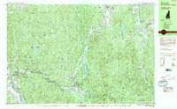
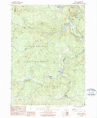
(22)- 1984 Map of Keene
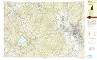 1984 Keene1984 Print · USGSCheshire County is captured in the mid-eighties as a hub of education and transit, centered on the growing city of Keene. Genealogists and historians can trace the Boston and Maine rail corridor, the grounds of St Josephs Cem, and landmarks like Goose Pond.2 unique versions available
 - 1984 Map of Saxtons River
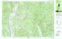
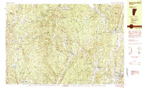 1984 Saxtons River1984 Print · USGSSoutheast Vermont in the 1980s was a landscape of deep river valleys and small villages tucked between the hills. Researchers can trace historic family burial sites at Middletown Cem, follow old roads through Lawrence Four Corners, and locate former mills at Brockways Mills.2 unique versions available
 - 1984 Map of Townshend
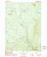
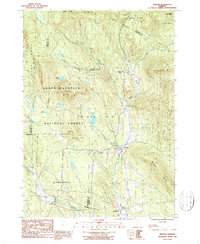
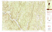 1984 Townshend1984 Print · USGSWindham County life in the mid-1980s is centered on the river valley and the wooded heights of the Green Mountains. Researchers can locate civic landmarks like the Town Hall (Round School) or trace family roots at Riverside Cem and Wiswall Cem.2 unique versions available
 - 1984 Map of Newfane
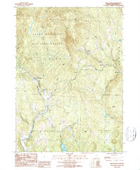
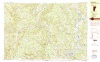 1984 Newfane1984 Print · USGSWindham County, Vermont, is captured in the mid-1980s as its river valleys and hill settlements maintained their traditional character. Researchers can trace ancestral sites at Newfane Hill Cem or the Old North Burying Ground and locate the former Putney Station along the river.2 unique versions available
 - 1984 Map of Winchester
 1984 Winchester1984 Print · USGSCheshire County in the 1980s is defined by the industrial Ashuelot River corridor and the vast woods of Pisgah State Park. Genealogists and historians can locate Evergreen Cem, the historic Meetinghouse Hill, and old rail junctions like Dole Junction.2 unique versions available
 - 1984 Map of Brattleboro
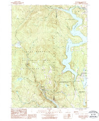
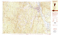 1984 Brattleboro1984 Print · USGSBrattleboro and the Connecticut River valley are shown in the mid-1980s, revealing a landscape of historic hill settlements and modern energy infrastructure. Genealogists can trace early homesteads near The Old Muster Ground or locate family plots in Oak Grove Cem and King Cem.2 unique versions available
 - 1985 Map of Walpole
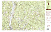
 1985 Walpole1985 Print · USGSThe Connecticut River valley in the mid-1980s shows a landscape of upland villages and riverside rail connections along the Vermont and New Hampshire border. Genealogists and historians can trace family-named landmarks like Dodge Tavern, Kingsbury Hill, and St Peters Cem.2 unique versions available
 - 1985 Map of Bellows Falls
 1985 Bellows Falls1985 Print · USGSThe Connecticut River valley comes alive in the mid-eighties as it passes through the industrial hubs and riverside meadows of the Vermont-New Hampshire border. Trace the rail lines of the Boston and Maine or locate family landmarks near Pine Grove Cem and South Acworth.2 unique versions available
 - 1985 Map of Claremont, 1986 Print
 1985 Claremont1986 Print · USGSUpper Valley and Green Mountain life are captured here in the mid-eighties, centered on the river-linked hubs of Claremont and Springfield. Trace old family routes and rail lines like the Boston & Maine RR, or locate properties near Lake Sunapee and Mount Ascutney State Park.2 unique versions available
 - 1986 Map of Glens Falls
 1986 Glens Falls1986 Print · USGSThe Upper Hudson Valley and Vermont borderlands come together in this mid-eighties survey of industrial river towns and mountain retreats. Genealogists and historians can trace the rail lines of the Delaware and Hudson Railway or locate landmarks like the Mount McGregor Correctional Facility and Saratoga Spa State Park.2 unique versions available
 - 1986 Map of Albany
 1986 Albany1986 Print · USGSThe Capital District and the tri-state highlands come into focus during the mid-eighties as urban growth meets the edge of the Green Mountains. Researchers can trace historic industrial sites and landmarks like the Watervliet Arsenal, the Bennington Battle Monument, and the grounds of Rensselaer Polytechnic Institute.
 - 1986 Map of Keene
 1986 Keene1986 Print · USGSThe tri-state borderlands of the Connecticut River Valley come alive in this mid-eighties survey of southern Vermont, New Hampshire, and Massachusetts. Genealogists and historians can trace rail-era villages like Ashuelot and Millers Falls alongside landmarks like Marlboro College and Monadnock Mountain.3 unique versions available
 - 1986 Map of Jamaica, 1987 Print
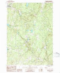
 1986 Jamaica1987 Print · USGSWindham County life in the 1980s is centered on the West River valley and the high slopes of the Green Mountain range. Genealogists and historians can trace several village centers, from South Wardsboro to Wardsboro Center, along with local landmarks like Pikes Falls and Adam Pond.
 - 1986 Map of Londonderry, 1987 Print
 1986 Londonderry1987 Print · USGSWindham County at the dawn of the late eighties shows a landscape where mountain wilderness meets riverside villages. Genealogists and historians can locate old Cemeteries, the quiet hamlet of Thompsonburg, and the layout of South Londonderry along the West River.
 - 1986 Map of Stratton Mtn, 1987 Print
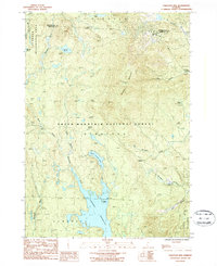 1986 Stratton Mtn1987 Print · USGSWindham County's high ridges and glacial ponds are captured here in the mid-eighties as a vast wilderness and recreation hub. Hikers can trace the Appalachian Trail across Stratton Mountain or find old cemeteries and landmarks in Pike Hollow.3 unique versions available
 - 1986 Map of Mount Snow, 1987 Print
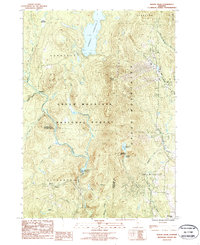 1986 Mount Snow1987 Print · USGSThe Green Mountains in the mid-1980s reveal a landscape of high-altitude reservoirs and developing ski peaks. Genealogists and hikers can trace the remote reaches of Somerset and Searsburg or locate landmarks like Mount Snow and Haystack Pond.
 - 1986 Map of Weston, 1987 Print
 1986 Weston1987 Print · USGSIn the mid-1980s, the mountain valleys of Windsor County maintained a quiet network of small settlements and protected forests. Trace the secluded grounds of Weston Priory, family plots at Cem sites, and the heights of Morgan Hill.2 unique versions available
 - 1986 Map of West Dover, 1987 Print
 1986 West Dover1987 Print · USGSWindham County's rugged terrain is charted here during the mid-eighties, showing the crossroads of high forest and valley hamlets. Researchers can trace family-named heights like Higley Hill and Stratton Hill or locate old settlements at Goose City and East Dover.
 - 1987 Map of Readsboro
 1987 Readsboro1987 Print · USGSThe Green Mountains of Southern Vermont are shown in the late twentieth century as a landscape defined by deep river valleys and hydroelectric power. Genealogists and local historians can trace family-named sites like Jarvis Hill and Castle Hill alongside the villages of Readsboro and Whitingham.2 unique versions available
 - 1987 Map of Jacksonville
 1987 Jacksonville1987 Print · USGSWindham County in the late eighties remains a land of high ridges and deep reservoirs. You can trace family roots through the townships of Wilmington and Halifax or locate landmarks like Molly Stark State Park and Sadawga Lake.2 unique versions available
 - 1989 Map of Glens Falls
 1989 Glens Falls1989 Print · USGSThe Upper Hudson Valley and the Vermont borderlands are captured here during the late eighties, showing a landscape of river-town industry and mountain recreation. Researchers can trace the Champlain Canal, the Delaware and Hudson RR, and historic sites like Saratoga National Historical Park.
 - 1989 Map of Albany
 1989 Albany1989 Print · USGSThe tri-state intersection of New York, Vermont, and Massachusetts comes alive in the late 1980s, centered on the historic river confluence of the Capital District. Researchers can trace the extensive rail lines of the D & H RR and explore high peaks like Mount Greylock or the reaches of the Tomhannock Reservoir.2 unique versions available
End of results
Showing maps 1-22 of 22
Top cities of Windham County
- Brattleboro historical maps
- Rockingham historical maps
- Westminster historical maps
- Vernon historical maps
- Guilford historical maps
- Londonderry historical maps
See more
Frequently asked questions
- What are the different types of historical maps available for Windham County?
- What is the oldest map of Windham County?
- Where can I purchase historical maps of Windham County for my home or office?
- Where can I download high-res historical maps of Windham County?
- Are there historical topographic maps available for Windham County?
- Is there historical aerial imagery available for Windham County?
- Where are historical maps of Windham County sourced from?