1990s Maps of Wardsboro, Vermont
Explore 5 historic maps of Wardsboro from the 1990s. These maps offer a rare glimpse into what life looked like during the 1990s — showing old roads, neighborhoods, homes, and landmarks that have changed or disappeared over time.
Whether you're researching your family's past, planning a metal detecting trip, or studying how Wardsboro's landscape evolved across the 1990s, these high-resolution maps are a powerful tool for exploring the history of this region.
- Focus on a specific era: All maps on this page are from the 1990s, giving you a focused view of this time period.
- See what’s changed: Compare century-old streets, trails, and buildings to today's modern landscape using overlays and satellite layers.
- Research with precision: Use these maps for genealogy, historical research, land use analysis, or educational projects.
- View, download, or print: Maps are fully viewable online in high resolution, and can be downloaded or printed for your own records.
Start exploring Wardsboro's history through authentic maps from the 1990s. This is your window into the past.
Wardsboro, VT maps
(5)- 1997 Map of Jamaica, 2000 Print
 1997 Jamaica2000 Print · USGSWindham County at the close of the twentieth century shows a landscape defined by the rugged Green Mountains and the winding West River. Researchers can trace historic settlements from Jamaica to the small community of Podunk, while locating remote landmarks like South Hill Cem and Pikes Falls.
 - 1997 Map of Stratton Mountain, 2000 Print
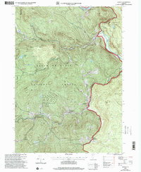
 1997 Stratton Mountain2000 Print · USGSThe Green Mountain National Forest is shown here during the late 1990s, where the Long and Appalachian Trails meet. Hikers and historians can locate the Daniel Webster Historical Monument and remote stops like Vondell Shelter or Stratton Pond.
 - 1997 Map of Mount Snow, 2000 Print
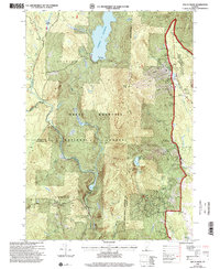 1997 Mount Snow2000 Print · USGSThe Green Mountains of Windham County are shown here in the late nineties, showcasing a landscape of high-elevation recreation and forest management. Researchers can trace the development of the Mount Snow Ski Area, find the quiet site of Somerset, and locate the Searsburg Reservoir along the Deerfield River.
 - 1997 Map of West Dover, 2000 Print
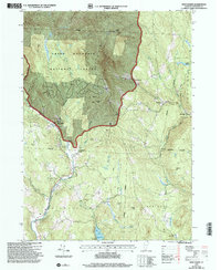 1997 West Dover2000 Print · USGSWindham County at the close of the twentieth century shows a landscape where mountain wilderness and village life intersect. Genealogists and hikers can trace old roads through the Green Mountain National Forest or locate family sites near East Dover, Goose City, and the shores of Lake Raponda.
 - 1997 Map of Townshend, 2000 Print
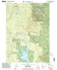
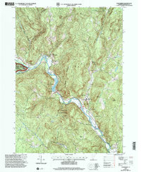 1997 Townshend2000 Print · USGSThe West River valley in the late nineties shows a landscape of mountain-shadowed villages and significant water management. Researchers can locate several family and community burial sites like Taft Cem or Oakwood Cem and trace the reservoir's impact on the land.
End of results
Showing maps 1-5 of 5
Top cities near Wardsboro
- Brattleboro historical maps
- Westminster historical maps
- Manchester historical maps
- Guilford historical maps
- East Dorset historical maps
- Dorset historical maps
See more
Top neighborhoods of Wardsboro
- Podunk historical maps
- South Wardsboro historical maps
- Wardsboro Center historical maps
- West Wardsboro historical maps
Frequently asked questions
- What are the different types of historical maps available for Wardsboro?
- What is the oldest map of Wardsboro?
- Where can I purchase historical maps of Wardsboro for my home or office?
- Where can I download high-res historical maps of Wardsboro?
- Are there historical topographic maps available for Wardsboro?
- Is there historical aerial imagery available for Wardsboro?
- Where are historical maps of Wardsboro sourced from?