1980s Maps of Norwich, Vermont
Explore 5 historic maps of Norwich from the 1980s. These maps offer a rare glimpse into what life looked like during the 1980s — showing old roads, neighborhoods, homes, and landmarks that have changed or disappeared over time.
Whether you're researching your family's past, planning a metal detecting trip, or studying how Norwich's landscape evolved across the 1980s, these high-resolution maps are a powerful tool for exploring the history of this region.
- Focus on a specific era: All maps on this page are from the 1980s, giving you a focused view of this time period.
- See what’s changed: Compare century-old streets, trails, and buildings to today's modern landscape using overlays and satellite layers.
- Research with precision: Use these maps for genealogy, historical research, land use analysis, or educational projects.
- View, download, or print: Maps are fully viewable online in high resolution, and can be downloaded or printed for your own records.
Start exploring Norwich's history through authentic maps from the 1980s. This is your window into the past.
Norwich, VT maps
(5)- 1981 Map of Sharon
 1981 Sharon1981 Print · USGSThe White River valley in the early eighties shows a landscape of mountain forests and river-bottom transport. You can locate family landmarks like the Joseph Smith Monument, the Button Cem, and the old Covered Bridge.2 unique versions available
 - 1981 Map of South Strafford
 1981 South Strafford1981 Print · USGSThe rural uplands of Orange County come into focus in the early eighties, documenting a landscape shaped by mining and the Ompompanoosuc River. Researchers can trace the industrial footprint of the Elizabeth Mine, locate family plots at Kibling Cem, or find the Covered Bridge at Union Village.2 unique versions available
 - 1981 Map of Lyme
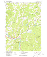
 1981 Lyme1981 Print · USGSThe Upper Valley of the Connecticut River comes alive in the early eighties, showcasing the rural character of Vermont and New Hampshire. Genealogists and local historians can trace family ties through Lyme Cem, Highland Cem, and the historic Thetford Academy.3 unique versions available
 - 1984 Map of Canaan
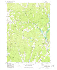
 1984 Canaan1984 Print · USGSGrafton County in the early eighties shows a landscape of clustered village centers and emerging wildlife management areas. Genealogists and local historians can trace family roots through the settlements of Canaan Street, Hanover Center, and the historic Shaker Hill district.3 unique versions available
 - 1985 Map of Rutland, 1988 Print
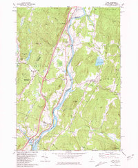
 1985 Rutland1988 Print · USGSThe Upper Valley of the mid-1980s comes to life along the winding Connecticut River as it divides the Green Mountain and Granite states. Historians can trace the industrial rail hubs of White River Junction and the paths of the Appalachian Trail and Long Trail.
End of results
Showing maps 1-5 of 5
Top cities near Norwich
- Lebanon historical maps
- Hanover historical maps
- Hartford historical maps
- Randolph historical maps
- Enfield historical maps
- Hartland historical maps
See more
Top neighborhoods of Norwich
- Pompanoosuc historical maps
- Lewiston historical maps
- Bragg historical maps
- Goodrich Four Corners historical maps
- New Boston historical maps
- West Norwich historical maps
See more
Frequently asked questions
- What are the different types of historical maps available for Norwich?
- What is the oldest map of Norwich?
- Where can I purchase historical maps of Norwich for my home or office?
- Where can I download high-res historical maps of Norwich?
- Are there historical topographic maps available for Norwich?
- Is there historical aerial imagery available for Norwich?
- Where are historical maps of Norwich sourced from?