Old Maps of Woodstock, Vermont for Genealogy
Trace your family roots with 25 historic maps of Woodstock. These high-res maps reveal old neighborhoods, homesites, landmarks, and streets — helping you uncover where your ancestors lived and how the area evolved over time.
- Explore historic neighborhoods: Identify where your relatives may have lived in the 1800s or 1900s.
- Compare maps over time: Trace the changes in streets, buildings, and landmarks for multi-generational research.
- Perfect for genealogy & ancestry research: Used by family historians and researchers to map out lineage and migration.
These maps are an incredible resource for exploring your personal connection to Woodstock's past.
Woodstock, VT maps
(25)- 1906 Map of Hanover, 1956 Print
 1906 Hanover1956 Print · USGSThe Upper Connecticut River Valley at the turn of the century is a hub of rail activity and collegiate life. Researchers can trace the early footprints of Dartmouth College or locate vanished rail infrastructure at White River Junction and Deweys Mills.2 unique versions available
 - 1908 Map of Hanover
 1908 Hanover1908 Print · USGSThe Upper Valley at the dawn of the twentieth century was a vital junction of Vermont and New Hampshire rail lines and river commerce. Researchers can trace the early layout of Dartmouth College, the rail yards of White River Junction, and numerous rural schoolhouses like Podunk School.7 unique versions available
 - 1911 Map of Woodstock, 1958 Print
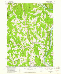
 1911 Woodstock1958 Print · USGSWindsor County villages and mountain hollows are captured here at the dawn of the twentieth century. Researchers can trace the early path of the Woodstock Railroad or locate family sites near the Town Farm and Plymouth Notch.
 - 1913 Map of Woodstock
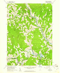
 1913 Woodstock1913 Print · USGSWindsor County villages and narrow valley settlements are captured here in the decade before the First World War. Genealogists can trace family lines through numerous rural schoolhouses like Mendall School and early post offices at Bridgewater Center Briggs P O.5 unique versions available
 - 1943 Map of Woodstock
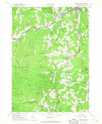
 1943 Woodstock1943 Print · USGSWindsor County's high country and river valleys are captured here during the early 1940s, showing a landscape of small hill farms and rural schools. Researchers can locate many former community hubs like English Mills, the Town Farm, and Notown.
 - 1950 Map of Glens Falls
 1950 Glens Falls1950 Print · USGSThe Adirondacks and the Green Mountains meet in this mid-century survey of the New York and Vermont borderlands. Researchers can trace the industrial rail corridors of the Rutland RR and Delaware & Hudson RR connecting Glens Falls, Rutland, and the shores of Lake George.
 - 1956 Map of Glens Falls, 1968 Print
 1956 Glens Falls1968 Print · USGSUpper New York and the Vermont mountains are captured here in the mid-fifties, showing the rugged rail-and-river network of the Northeast. Researchers can trace the paths of the Delaware and Hudson RR and Rutland RR as they wind through valley towns like Poultney and Whitehall.3 unique versions available
 - 1959 Map of Glens Falls
 1959 Glens Falls1959 Print · USGSUpper New York and Vermont are captured here during the late 1950s, a period of transition for these mountain communities. Researchers can trace the legacy of the region's river-and-rail economy through landmarks like Lake George, Saratoga Springs, and Killington Peak.2 unique versions available
 - 1959 Map of Hartland, 1961 Print
 1959 Hartland1961 Print · USGSThe Connecticut River valley south of White River Junction shows its mid-century character, from the State Prison Farm to the North Hartland Reservoir. Researchers can trace old family names at Quaker Village Cem and locate historic sites like Jenneville and the Covered Bridge.4 unique versions available
 - 1959 Map of Quechee, 1961 Print
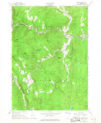
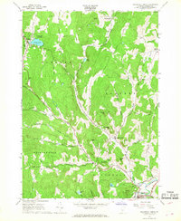
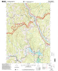
 1959 Quechee1961 Print · USGSEastern Windsor County in the late fifties shows a landscape of river-valley industry and upland farms. Genealogists and hikers can trace the Appalachian Trail through West Hartford or locate family plots at Bunker Hill Cem and Savage Cem.5 unique versions available
 - 1964 Map of Glens Falls
 1964 Glens Falls1964 Print · USGSThe tri-state borderlands of New York, Vermont, and New Hampshire appear here in the mid-1960s. Researchers can trace the rail routes of the Rutland RR and find historic sites like Ticonderoga and Saratoga National Historical Park.
 - 1966 Map of Plymouth, 1968 Print
 1966 Plymouth1968 Print · USGSWindsor County as it appeared in the mid-sixties reveals a landscape of presidential heritage and mountain recreation. Genealogists and historians can locate family landmarks like Toplift Cem and trace the development of the Calvin Coolidge Birthplace near Plymouth Notch.2 unique versions available
 - 1966 Map of Woodstock South, 1968 Print
 1966 Woodstock South1968 Print · USGSWindsor County in the mid-1960s reflects a landscape of river-valley villages and high mountain forests. Researchers can trace family sites near Riverside Cemetery, locate the Covered Bridge over the Ottauquechee River, or follow the Long Trail.3 unique versions available
 - 1966 Map of Woodstock North, 1968 Print
 1966 Woodstock North1968 Print · USGSThe rural highlands of Windsor County come alive in this mid-century survey of Barnard and Pomfret. Genealogists and historians can trace family locations through Old Cem and Burns Cem, or follow the high-country path of the APPALACHIAN TRAIL.3 unique versions available
 - 1976 Map of Woodstock North, 1988 Print
 1976 Woodstock North1988 Print · USGSWindsor County in the mid-1970s shows a landscape of traditional hill settlements and growing recreational corridors. Researchers can trace the path of the Appalachian Trail or locate family sites near Village Cem, Central Sch, and the Woodstock Royalton Turnpike.
 - 1985 Map of Rutland, 1988 Print
 1985 Rutland1988 Print · USGSThe Upper Valley of the mid-1980s comes to life along the winding Connecticut River as it divides the Green Mountain and Granite states. Historians can trace the industrial rail hubs of White River Junction and the paths of the Appalachian Trail and Long Trail.
 - 1996 Map of Quechee, 2000 Print
 1996 Quechee2000 Print · USGSWindsor County in the late nineties showcases a landscape where the Ottauquechee River meets ancient colonial routes and deep forest preserves. Researchers can trace family history through numerous local sites like Centertown Cem, Deweys Mills, and the Taftsville covered bridge.
 - 1997 Map of Woodstock North, 2000 Print
 1997 Woodstock North2000 Print · USGSWindsor County in the late 1990s showcases a landscape of highland villages and protected wilderness before the modern era. Genealogists and historians can trace family plots at Village Cem or Cushing Cem and locate landmarks like Central Sch and the Appalachian National Scenic Trail.
 - 1998 Map of Hartland, 1999 Print
 1998 Hartland1999 Print · USGSLate twentieth-century Windsor County reveals a landscape of high hills and river junctions along the New Hampshire border. Genealogists can trace family names across Hoisington Cem, Aldrich Cem, and historic hamlets like Quakers Village.
 - 1998 Map of Woodstock South, 1999 Print
 1998 Woodstock South1999 Print · USGSWindsor County, Vermont, retained its classic New England character in the late nineties, from the river valleys to the high state forest peaks. Researchers can trace family history through many small burial sites like Riverside Cemetery or explore the transit history found at the Covered Bridge and Reading Center.
 - 2024 Map of Hartland, 2024 Print
 2024 Hartland2024 Print · USGSThe Upper Connecticut River Valley at the Vermont-New Hampshire border is shown here with its network of rural settlements. Researchers can trace family history through local landmarks like Hartland Four Corners, Hoisington Cem, and the Saint-Gaudens National Historic Site.
 - 2024 Map of Woodstock South, 2024 Print
 2024 Woodstock South2024 Print · USGSWoodstock and the high hill country of central Vermont appear here in contemporary detail. Genealogists and historians can locate numerous small burial sites like Mendall Cem and Walker-Jaquith Cem or trace the rural routes of South Woodstock.
 - 2024 Map of Quechee, 2024 Print
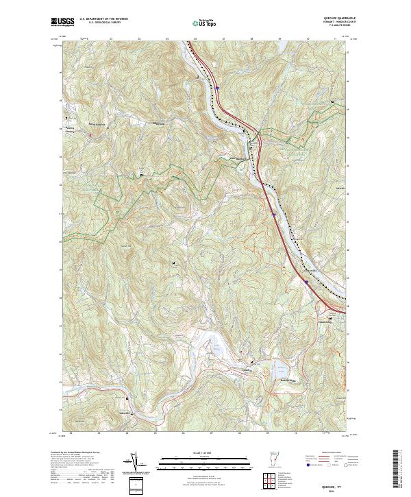 2024 Quechee2024 Print · USGSWindsor County communities line the river valleys and timbered ridges of this Vermont quadrangle in 2024. Genealogists and local historians can trace family locations near the Center of Town Cem, Deweys Mills, and the winding Appalachian National Scenic Trail.
 - 2024 Map of Plymouth, 2024 Print
 2024 Plymouth2024 Print · USGSThe Green Mountains of Windsor County are shown here in modern detail, covering the historic clusters of Plymouth Notch and Bridgewater Center. Researchers can trace old family burial sites at Topliff Cem or follow the path of the Ottauquechee River.
 - 2024 Map of Woodstock North, 2024 Print
 2024 Woodstock North2024 Print · USGSThe hills of Windsor County, Vermont, are shown in this contemporary study of historic hamlets and high-country ridges. Genealogists can trace family roots through numerous burying grounds like Village Cem and Perkins Cem or explore the grounds of Marsh-Billings-Rockefeller National Historical Park.
End of results
Showing maps 1-25 of 25
Top cities near Woodstock
- Lebanon historical maps
- Claremont historical maps
- Hartford historical maps
- Hartland historical maps
- Norwich historical maps
- Woodstock Village historical maps
See more
Top neighborhoods of Woodstock
- West Woodstock historical maps
- Prosper historical maps
- Taftsville historical maps
- Woodstock Village historical maps
- South Woodstock Historic District historical maps
Frequently asked questions
- What are the different types of historical maps available for Woodstock?
- What is the oldest map of Woodstock?
- Where can I purchase historical maps of Woodstock for my home or office?
- Where can I download high-res historical maps of Woodstock?
- Are there historical topographic maps available for Woodstock?
- Is there historical aerial imagery available for Woodstock?
- Where are historical maps of Woodstock sourced from?