1970s Maps of Logan Village, Virginia
Explore 3 historic maps of Logan Village from the 1970s. These maps offer a rare glimpse into what life looked like during the 1970s — showing old roads, neighborhoods, homes, and landmarks that have changed or disappeared over time.
Whether you're researching your family's past, planning a metal detecting trip, or studying how Logan Village's landscape evolved across the 1970s, these high-resolution maps are a powerful tool for exploring the history of this region.
- Focus on a specific era: All maps on this page are from the 1970s, giving you a focused view of this time period.
- See what’s changed: Compare century-old streets, trails, and buildings to today's modern landscape using overlays and satellite layers.
- Research with precision: Use these maps for genealogy, historical research, land use analysis, or educational projects.
- View, download, or print: Maps are fully viewable online in high resolution, and can be downloaded or printed for your own records.
Start exploring Logan Village's history through authentic maps from the 1970s. This is your window into the past.
Logan Village, VA maps
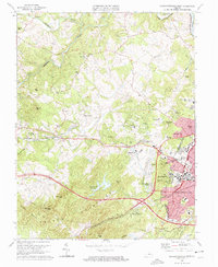
(3)- 1972 Map of Charlottesville West, 1974 Print
 1972 Charlottesville West1974 Print · USGSAlbemarle County comes into sharp focus in the early seventies through this detailed aerial orthophotomap of the Piedmont. Researchers can trace the mid-century expansion of local infrastructure along Route 250 and examine the wooded slopes of the Ragge Mountains.
 - 1973 Map of Charlottesville West, 1974 Print
 1973 Charlottesville West1974 Print · USGSAlbemarle County and the western reaches of Charlottesville appear here during a period of rapid institutional growth in the early seventies. Genealogists and historians can trace family-named summits like Turners Mtn and Clark Mtn or locate local landmarks including Olivet Ch and Sherwood Farms.3 unique versions available
 - 1977 Map of Charlottesville West, 1982 Print
 1977 Charlottesville West1982 Print · USGSWestern Albemarle County at the end of the seventies is seen here through detailed aerial imagery of the developing countryside. Researchers can trace the layout of Farmington or locate the rural outskirts of Owensville and Millington.
End of results
Showing maps 1-3 of 3
Top cities near Logan Village
- Charlottesville historical maps
- Lake Monticello historical maps
- Hollymead historical maps
- University of Virginia historical maps
- Crozet historical maps
- Pantops historical maps
See more
Frequently asked questions
- What are the different types of historical maps available for Logan Village?
- What is the oldest map of Logan Village?
- Where can I purchase historical maps of Logan Village for my home or office?
- Where can I download high-res historical maps of Logan Village?
- Are there historical topographic maps available for Logan Village?
- Is there historical aerial imagery available for Logan Village?
- Where are historical maps of Logan Village sourced from?