1970s Maps of Newtown, Virginia
Explore 3 historic maps of Newtown from the 1970s. These maps offer a rare glimpse into what life looked like during the 1970s — showing old roads, neighborhoods, homes, and landmarks that have changed or disappeared over time.
Whether you're researching your family's past, planning a metal detecting trip, or studying how Newtown's landscape evolved across the 1970s, these high-resolution maps are a powerful tool for exploring the history of this region.
- Focus on a specific era: All maps on this page are from the 1970s, giving you a focused view of this time period.
- See what’s changed: Compare century-old streets, trails, and buildings to today's modern landscape using overlays and satellite layers.
- Research with precision: Use these maps for genealogy, historical research, land use analysis, or educational projects.
- View, download, or print: Maps are fully viewable online in high resolution, and can be downloaded or printed for your own records.
Start exploring Newtown's history through authentic maps from the 1970s. This is your window into the past.
Newtown, VA maps
(3)- 1972 Map of Waynesboro East, 1974 Print
 1972 Waynesboro East1974 Print · USGSWaynesboro and the surrounding valley floor are captured at the start of the seventies as the city grew toward the mountains. Trace the development of Waynesboro and the wooded slopes of the Blue Ridge through detailed aerial photography.
 - 1973 Map of Waynesboro East, 1974 Print
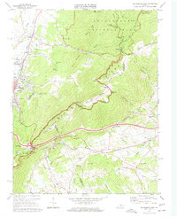 1973 Waynesboro East1974 Print · USGSThe Blue Ridge mountains meet the Shenandoah Valley in the early 1970s, showcasing a landscape defined by historic rail and high-ridge trails. Trace local genealogy and industry through the Blue Ridge Tunnel, the Greenwood School, and Critzers Shop.2 unique versions available
 - 1977 Map of Waynesboro East, 1982 Print
 1977 Waynesboro East1982 Print · USGSThe eastern Blue Ridge and the city of Waynesboro are captured in high detail at the end of the seventies. Genealogists and historians can trace the rural layouts of Newtown and Afton or locate landmarks like Rockfish Gap and Skyline Drive.
End of results
Showing maps 1-3 of 3
Top cities near Newtown
- Waynesboro historical maps
- Crozet historical maps
- Verona historical maps
- Grottoes historical maps
- Crimora historical maps
- Lyndhurst historical maps
See more
Frequently asked questions
- What are the different types of historical maps available for Newtown?
- What is the oldest map of Newtown?
- Where can I purchase historical maps of Newtown for my home or office?
- Where can I download high-res historical maps of Newtown?
- Are there historical topographic maps available for Newtown?
- Is there historical aerial imagery available for Newtown?
- Where are historical maps of Newtown sourced from?