1970s Maps of White Hall, Virginia
Explore 2 historic maps of White Hall from the 1970s. These maps offer a rare glimpse into what life looked like during the 1970s — showing old roads, neighborhoods, homes, and landmarks that have changed or disappeared over time.
Whether you're researching your family's past, planning a metal detecting trip, or studying how White Hall's landscape evolved across the 1970s, these high-resolution maps are a powerful tool for exploring the history of this region.
- Focus on a specific era: All maps on this page are from the 1970s, giving you a focused view of this time period.
- See what’s changed: Compare century-old streets, trails, and buildings to today's modern landscape using overlays and satellite layers.
- Research with precision: Use these maps for genealogy, historical research, land use analysis, or educational projects.
- View, download, or print: Maps are fully viewable online in high resolution, and can be downloaded or printed for your own records.
Start exploring White Hall's history through authentic maps from the 1970s. This is your window into the past.
White Hall, VA maps
(2)- 1973 Map of Crozet, 1974 Print
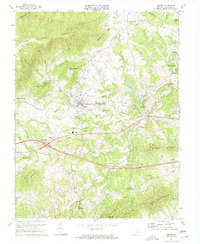 1973 Crozet1974 Print · USGSAlbemarle County in the early 1970s shows the growth of the Crozet area alongside deep-rooted rural institutions. Genealogists can locate family landmarks like Miller School, the Hillsboro Cem, and old stops on the Chesapeake and Ohio railroad.2 unique versions available
 - 1977 Map of Crozet, 1982 Print
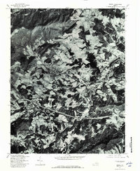 1977 Crozet1982 Print · USGSWestern Albemarle County comes into sharp focus during the late seventies, showing the traditional crossroads and farmsteads of the Blue Ridge foothills. Genealogists and local historians can trace family lands near White Hall, Crozet, and the banks of Mechums River.
End of results
Showing maps 1-2 of 2
Top cities near White Hall
- Charlottesville historical maps
- Hollymead historical maps
- University of Virginia historical maps
- Crozet historical maps
- Pantops historical maps
- Grottoes historical maps
See more
Frequently asked questions
- What are the different types of historical maps available for White Hall?
- What is the oldest map of White Hall?
- Where can I purchase historical maps of White Hall for my home or office?
- Where can I download high-res historical maps of White Hall?
- Are there historical topographic maps available for White Hall?
- Is there historical aerial imagery available for White Hall?
- Where are historical maps of White Hall sourced from?