1960s Maps of Amherst County, Virginia
Explore 20 historic maps of Amherst County from the 1960s. These maps offer a rare glimpse into what life looked like during the 1960s — showing old roads, neighborhoods, homes, and landmarks that have changed or disappeared over time.
Whether you're researching your family's past, planning a metal detecting trip, or studying how Amherst County's landscape evolved across the 1960s, these high-resolution maps are a powerful tool for exploring the history of this region.
- Focus on a specific era: All maps on this page are from the 1960s, giving you a focused view of this time period.
- See what’s changed: Compare century-old streets, trails, and buildings to today's modern landscape using overlays and satellite layers.
- Research with precision: Use these maps for genealogy, historical research, land use analysis, or educational projects.
- View, download, or print: Maps are fully viewable online in high resolution, and can be downloaded or printed for your own records.
Start exploring Amherst County's history through authentic maps from the 1960s. This is your window into the past.
Amherst County, VA maps
(20)- 1961 Map of Shipman, 1963 Print
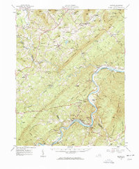 1961 Shipman1963 Print · USGSNelson County's rugged ridges and the James River corridor are captured here in the early 1960s, showing a landscape defined by rail lines and rural community life. Researchers can trace historic church sites like White Rock Ch, the rail hub at Gladstone, and the grounds of the County Training Sch.2 unique versions available
 - 1963 Map of Roanoke
 1963 Roanoke1963 Print · USGSCentral Virginia and the Blue Ridge front appear here in the early sixties, caught between their deep railroad roots and new postwar developments. Genealogists and historians can trace the rail lines of the Norfolk and Western through towns like Bedford and Altavista, or locate family landmarks near Smith Mountain Lake.
 - 1963 Map of Kelly, 1965 Print
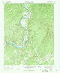
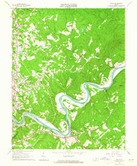 1963 Kelly1965 Print · USGSThe James River corridor in the early 1960s reveals a landscape of industrial railways and deep-rooted family homesteads. Genealogists and historians can trace the locations of Brightwell Mill, the Oxford Furnace site, and family cemeteries like Megginson Cem.3 unique versions available
 - 1963 Map of Piney River, 1965 Print
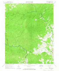
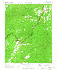
 1963 Piney River1965 Print · USGSIn the early 1960s, the Amherst and Nelson County border was a landscape of mountain hollows and industrial quarries. Researchers can trace the path of the Blue Ridge Railway or locate ancestral sites like Henleys Store and St Marys Ch.2 unique versions available
 - 1963 Map of Forks Of Buffalo, 1965 Print
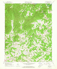
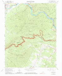
 1963 Forks Of Buffalo1965 Print · USGSAmherst County in the early sixties shows a landscape where mountain wilderness meets established valley farms. You can trace the Appalachian Trail through the forest or locate family landmarks like Dodds Store, Moss Rock Sch, and Dodd Cem.3 unique versions available
 - 1963 Map of Tobacco Row Mtn, 1965 Print
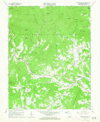
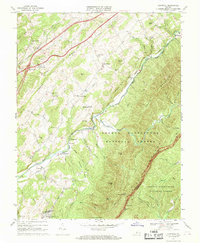
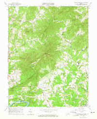 1963 Tobacco Row Mtn1965 Print · USGSAmherst County in the early sixties was defined by the ridges of Tobacco Row Mountain and its rural religious and educational centers. Researchers can locate numerous family burial grounds and institutions like the Father Judge Mission Seminary, Gatewood Cem, and New Prospect Ch.4 unique versions available
 - 1963 Map of Amherst, 1965 Print
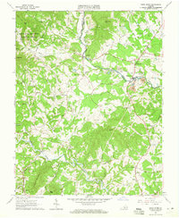
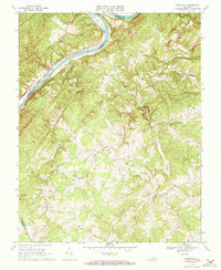
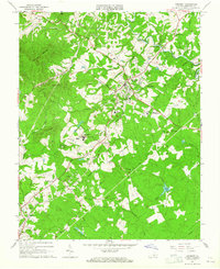 1963 Amherst1965 Print · USGSAmherst County in the early sixties centers on the rail-connected settlements and academic grounds of the Virginia Piedmont. Genealogists and historians can trace family locations near Sardis Ch, Christian Aid Cem, and the historic campus of Sweet Briar College.3 unique versions available
 - 1963 Map of Lynchburg, 1965 Print
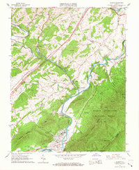
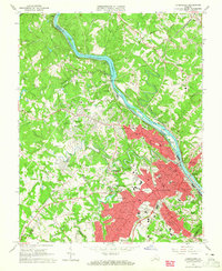 1963 Lynchburg1965 Print · USGSLynchburg and its surrounding heights are captured in the early sixties as the city expanded across the river and rail corridors. Genealogists can locate specific family landmarks like Spring Hill Cem, Dunbar High Sch, and the Randolph Macon Womans College campus.5 unique versions available
 - 1965 Map of Boonsboro, 1967 Print
 1965 Boonsboro1967 Print · USGSThe northern edge of Bedford County during the mid-sixties shows a landscape of prominent ridges and riverside industry along the James River. Genealogists can locate family landmarks such as Norwood Cem and Norwood Ch or trace the early development of Boonsboro.2 unique versions available
 - 1965 Map of Massies Mill, 1967 Print
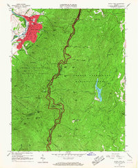
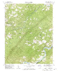
 1965 Massies Mill1967 Print · USGSNelson and Amherst Counties are captured here in the mid-1960s, showing the high ridge communities and valley settlements along the Tye River. Genealogists and hikers can trace the Appalachian Trail past peaks like The Priest or locate family sites at Sandy Ridge Cem and Massies Mill.2 unique versions available
 - 1965 Map of Buena Vista, 1967 Print
 1965 Buena Vista1967 Print · USGSThe industrial river valley and the high Blue Ridge meet in the mid-sixties around Buena Vista. Researchers can trace the Appalachian Trail across Humphreys Gap or locate family roots near Oronoco and the Southern Seminary Jr College campus.7 unique versions available
 - 1965 Map of Glasgow, 1967 Print
 1965 Glasgow1967 Print · USGSThe confluence of the Maury and James Rivers comes alive in the mid-1960s, showing a landscape defined by heavy rail and mountain wilderness. Genealogists and historians can trace family sites like Mt Lidia Cem and Poplar Hill Ch, or locate the industrial works at Buffalo Forge Station.2 unique versions available
 - 1965 Map of Big Island, 1967 Print
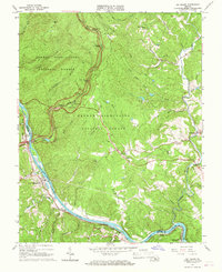 1965 Big Island1967 Print · USGSThe James River corridor in the mid-sixties reveals a landscape defined by the intersection of the Blue Ridge Parkway and the Chesapeake and Ohio Railway. Researchers can trace historic river communities and rural landmarks like Pedlar Mills, Coleman Falls, and Cornerstone Ch.3 unique versions available
 - 1965 Map of Montebello, 1967 Print
 1965 Montebello1967 Print · USGSThe high ridges of Rockbridge and Nelson counties come alive in the mid-sixties as the winding Blue Ridge Parkway meets the Appalachian Trail. Genealogists can locate family landmarks like Grant Cem and the Irish Creek settlement, or trace the remote Wiggins Spring Shelter and Fish Hatchery.4 unique versions available
 - 1966 Map of Snowden, 1979 Print
 1966 Snowden1979 Print · USGSThe James River gap and the Blue Ridge heights dominate this Virginia survey as they appeared in the 1960s. Researchers can trace the path of the Appalachian Trail, locate country churches like Sharon Ch, or study the rail corridor through Natural Bridge Station.2 unique versions available
 - 1967 Map of Cornwall, 1969 Print
 1967 Cornwall1969 Print · USGSRockbridge County's mountain settlements and forest gaps are frozen in time during the late sixties as the South River valley develops. Genealogists can locate family landmarks like Paxton Hill, Riverside Ch, and the high Clarks Mountain Cem.3 unique versions available
 - 1968 Map of Stonewall, 1971 Print
 1968 Stonewall1971 Print · USGSAppomattox County in the late sixties remains a landscape of river-fronting industry and quiet rural crossroads. Genealogists and researchers can find many church-centered communities and historic river landmarks, including Stonewall Mills, Mt Zion Cem, and Pettyjohn Island.2 unique versions available
 - 1969 Map of Gladstone, 1971 Print
 1969 Gladstone1971 Print · USGSThe James River corridor in the late 1960s reveals a landscape defined by its winding waterway and rail lines. Genealogists can trace family landmarks and community centers like Buffalo Station, Mineral Springs Ch, and the Gladstone Sch.4 unique versions available
 - 1969 Map of Arrington, 1971 Print
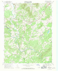 1969 Arrington1971 Print · USGSNelson County's river valleys and the Southern railroad corridor are captured here during a period of steady rural growth. Genealogists and local historians can trace family roots through numerous churches and cemeteries, from Roseland and Arrington to the Pine Hill Ch.4 unique versions available
 - 1969 Map of Buffalo Ridge, 1971 Print
 1969 Buffalo Ridge1971 Print · USGSAmherst and Nelson counties come together along the James River in the late sixties, showing a landscape of ridge-top lookouts and river-valley rails. Genealogists can locate family landmarks like Poplar Ch, St James Ch, and the rural community of Buffalo Ridge.2 unique versions available
End of results
Showing maps 1-20 of 20
Top cities of Amherst County
Frequently asked questions
- What are the different types of historical maps available for Amherst County?
- What is the oldest map of Amherst County?
- Where can I purchase historical maps of Amherst County for my home or office?
- Where can I download high-res historical maps of Amherst County?
- Are there historical topographic maps available for Amherst County?
- Is there historical aerial imagery available for Amherst County?
- Where are historical maps of Amherst County sourced from?