1970s Maps of Amherst County, Virginia
Explore 5 historic maps of Amherst County from the 1970s. These maps offer a rare glimpse into what life looked like during the 1970s — showing old roads, neighborhoods, homes, and landmarks that have changed or disappeared over time.
Whether you're researching your family's past, planning a metal detecting trip, or studying how Amherst County's landscape evolved across the 1970s, these high-resolution maps are a powerful tool for exploring the history of this region.
- Focus on a specific era: All maps on this page are from the 1970s, giving you a focused view of this time period.
- See what’s changed: Compare century-old streets, trails, and buildings to today's modern landscape using overlays and satellite layers.
- Research with precision: Use these maps for genealogy, historical research, land use analysis, or educational projects.
- View, download, or print: Maps are fully viewable online in high resolution, and can be downloaded or printed for your own records.
Start exploring Amherst County's history through authentic maps from the 1970s. This is your window into the past.
Amherst County, VA maps
(5)- 1971 Map of Roanoke, 1977 Print
 1971 Roanoke1977 Print · USGSThe Virginia Piedmont and Blue Ridge mountains meet in this early 1970s landscape of river valleys and rail hubs. Researchers can trace historic transportation routes and landmarks like the Appomattox Court House Nat Hist Pk, the Peaks of Otter, and Amelia Court House.2 unique versions available
 - 1977 Map of Lynchburg, 1983 Print
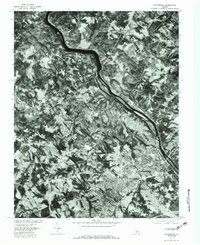 1977 Lynchburg1983 Print · USGSLynchburg and the surrounding Piedmont hills are shown in this detailed 1970s aerial survey, revealing the city's growth and the winding James River. Trace historical property lines and local neighborhoods like Peakland, Blue Ridge Farms, and the rail-side community of Monroe.
 - 1977 Map of Buena Vista, 1983 Print
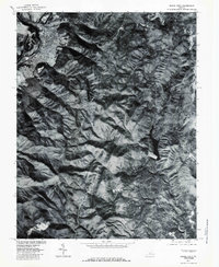 1977 Buena Vista1983 Print · USGSBuena Vista and the surrounding Blue Ridge mountains are captured in this late-seventies aerial survey at the junction of the mountains and the river. Genealogists and researchers can trace the paths between Beverlytown, Oronoco, and the Blue Ridge Parkway.
 - 1979 Map of Dillwyn, 1982 Print
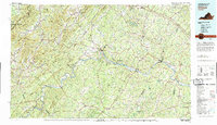 1979 Dillwyn1982 Print · USGSCentral Virginia in the late seventies is defined by the winding James River and the rural communities of the Piedmont. Trace old transportation corridors and family-named ridges from Dillwyn and Buckingham to the Blue Ridge foothills.
 - 1979 Map of Appomattox, 1982 Print
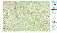 1979 Appomattox1982 Print · USGSSouthside Virginia in the late seventies remains a landscape of historic rail towns and vast state forests. Genealogists and historians can trace the routes of the Norfolk and Western through Farmville or locate ancestral sites near Hampden Sydney and Charlotte Court House.
End of results
Showing maps 1-5 of 5
Top cities of Amherst County
Frequently asked questions
- What are the different types of historical maps available for Amherst County?
- What is the oldest map of Amherst County?
- Where can I purchase historical maps of Amherst County for my home or office?
- Where can I download high-res historical maps of Amherst County?
- Are there historical topographic maps available for Amherst County?
- Is there historical aerial imagery available for Amherst County?
- Where are historical maps of Amherst County sourced from?