Old Maps of Bedford County, Virginia for Metal Detecting
Plan your next treasure hunt with 87 historic maps of Bedford County. Find old homesites, ghost towns, trails, and gathering spots that may be lost to time — perfect for identifying promising metal detecting locations.
- Locate forgotten sites: Uncover places like long-lost settlements, abandoned rail lines, or gathering spots.
- Plan better hunts: Use map overlays combined with LiDAR or satellite views to narrow in on historically rich areas.
- Made for detectorists: Thousands of hobbyists use these maps to discover relics, coins, and hidden history.
Use these historic maps to boost your research and find new opportunities beneath the surface of Bedford County.
Bedford County, VA maps
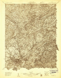
(87)- 1890 Map of Roanoke
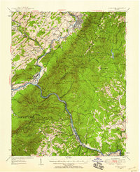
 1890 Roanoke1890 Print · USGSThe Roanoke Valley in the late nineteenth century was a growing rail and mining hub shaped by the Blue Ridge. Researchers can trace the early industrial footprint of the Rorer Mines or locate old community anchors like Dillons Mill and Hales Bridge.
 - 1891 Map of Roanoke
 1891 Roanoke1891 Print · USGSVirginia's Blue Ridge and Roanoke Valley come alive in the late nineteenth century, showing a landscape defined by new rail lines and old river crossings. Genealogists and local researchers can trace family landmarks and forgotten transport nodes like Rorer Mines, Hollins Inst., and Blackwater Ford.8 unique versions available
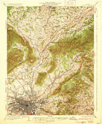
 - 1892 Map of Lynchburg
 1892 Lynchburg1892 Print · USGSCentral Virginia in the 1890s centered on the vital rail and river junction of Lynchburg and its surrounding tobacco-growing counties. Family historians can trace ancestral crossings at Wards Road Ferry, locate the Academy church, and follow the early Virginia Midland Rail Road through Evington.6 unique versions available
 - 1894 Map of Natural Bridge, 1898 Print
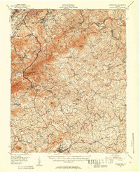
 1894 Natural Bridge1898 Print · USGSThe Virginia ridges thrived with iron furnaces and mineral springs during the 1890s. Genealogists and historians can trace the early industrial footprint of Long Dale Furnace and Victoria Mines, or locate local landmarks like Lick Run Ferry and Rapps Mill.7 unique versions available
 - 1894 Map of Lexington, 1900 Print
 1894 Lexington1900 Print · USGSAmherst and the surrounding Blue Ridge foothills are captured in the late nineteenth century during a period of rural expansion and early rail development. Genealogists can locate family homesteads near Clifford P.O. or trace landmarks like Cornerstone Ch. and Massies Mill.7 unique versions available
 - 1894 Map of Natural Bridge, 1926 Print
 1894 Natural Bridge1926 Print · USGSThe Virginia highlands during the 1890s were a powerhouse of iron production and river commerce. You can trace the rail-and-river economy through landmarks like the Lick Run Ferry, Victoria Mines, and the Long Dale Furnace.
 - 1907 Map of Natural Bridge Special
 1907 Natural Bridge Special1907 Print · USGSThe James River corridor in Botetourt and Rockbridge counties is captured here just after the turn of the century. Genealogists can locate family landmarks like Rapps Mill, Dunkard Church, and the riverfront settlement of Buchanan along the Chesapeake and Ohio RR.4 unique versions available
 - 1929 Map of Roanoke
 1929 Roanoke1929 Print · USGSThe Roanoke Valley is shown just before the Great Depression, documenting the area's transition from rural townships to a developing urban center. Genealogists can locate family landmarks such as Forest Chapel Sch, Coyner Springs, and the early neighborhoods of Riverdale.3 unique versions available
 - 1933 Map of Roanoke
 1933 Roanoke1933 Print · USGSThe Roanoke Valley in the early thirties shows a thriving rail-and-river hub surrounded by a landscape of small crossroads schools and churches. Genealogists can trace family names through landmarks like Hollins College, Gravel Hill Sch, and Trinity church.3 unique versions available
 - 1935 Map of Buena Vista
 1935 Buena Vista1935 Print · USGSThe James River corridor in the mid-1930s reveals a landscape of hydroelectric power and deep-rooted mountain communities. Genealogists and historians can locate dozens of country schools and churches, from Ivory Hill Sch to Mt Zion Ch, alongside industrial sites like the LONE JACK QUARRY.
 - 1935 Map of Amherst
 1935 Amherst1935 Print · USGSAmherst County in the mid-thirties reveals a landscape of mountain hollows and rail-connected settlements along the edge of the George Washington National Forest. Genealogists and historians can locate rural landmarks like the Indian Mission, Sweet Briar College, and the old Southern Mineral Plant.
 - 1939 Map of Amherst
 1939 Amherst1939 Print · USGSAmherst County in the mid-1930s is a landscape of mountain ridges and tight-knit rural communities. Genealogists and historians can trace the exact locations of many local landmarks, from Sweet Briar and Amherst to the Indian Mission and Dodds Store.
 - 1939 Map of Buena Vista
 1939 Buena Vista1939 Print · USGSThe James River corridor near Buena Vista was a bustling intersection of rail and water transport in the years before World War II. Researchers can trace the early Appalachian Trail and find rural community hubs like Pedlar Mills, CCC Camp No 10, and Buffalo Forge.
 - 1940 Map of Buena Vista
 1940 Buena Vista1940 Print · USGSThe industrial and rail corridor of the James River is captured here as the region's mountain economy evolved in the 1930s. Researchers can trace the dual rail lines serving Glasgow, find CCC Camp No 10, and locate rural landmarks like Buffalo Forge and Ben Salam Sch.2 unique versions available
 - 1944 Map of Lynchburg
 1944 Lynchburg1944 Print · USGSThe James River corridor hums with activity during the mid-1940s as four major railways converge on the industrial and collegiate city of Lynchburg. Researchers can trace old family sites and schools like the Rosenwald Sch, Oxford Furnace, and Galts Mill.3 unique versions available
 - 1947 Map of Roanoke, 1948 Print
 1947 Roanoke1948 Print · USGSCentral Virginia in the late 1940s reveals a region defined by its great mountain ridges and the powerful river-and-rail economy connecting Roanoke to Lynchburg. Researchers can trace the path of the Virginian RR and locate historic county seats like Charlotte Court House.2 unique versions available
 - 1950 Map of Goode, 1952 Print
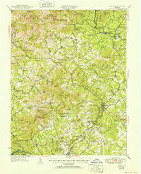
 1950 Goode1952 Print · USGSMid-century Bedford and Campbell Counties are documented here as the rural landscape meets the mountains. Genealogists can trace the location of numerous country landmarks like Poplar Forest, Coltons Mill, and the many schools and churches including North Bedford Ch.3 unique versions available
 - 1950 Map of Peaks of Otter, 1952 Print
 1950 Peaks of Otter1952 Print · USGSThe Blue Ridge highlands meet the Piedmont here in the mid-century, defined by the mountain peaks and the busy Norfolk and Western rail line. Genealogists can trace family landmarks like Walnut Grove Ch, Joppa Mill, and the small community of Thaxton.5 unique versions available
 - 1950 Map of Buena Vista, 1958 Print
 1950 Buena Vista1958 Print · USGSThe Blue Ridge high country is captured here at mid-century as the Blue Ridge Parkway and Appalachian Trail were becoming established. Genealogists and historians can trace family locations near Pedlar Mills, Buffalo Forge, and the riverside rail junction at Glasgow.2 unique versions available
 - 1950 Map of Amherst, 1960 Print
 1950 Amherst1960 Print · USGSAmherst and the surrounding Blue Ridge foothills are documented here at mid-century, just as rural communities and mountain gaps remained largely unchanged. Genealogists can trace family locations through Dodds Store, Mt Moriah Ch, and the Sweet Briar College campus.
 - 1950 Map of Lynchburg, 1963 Print
 1950 Lynchburg1963 Print · USGSMid-century Lynchburg and the surrounding Piedmont hills are caught in a moment of industrial and rail prominence. Researchers can trace the legacy of local commerce and community through landmarks like Oxford Furnace, Tomahawk Mill, and Lynchburg Womens College.
 - 1951 Map of Boones Mill, 1953 Print
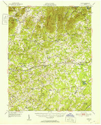
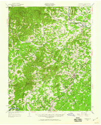
 1951 Boones Mill1953 Print · USGSFranklin and Roanoke Counties are captured in the early fifties, showing the Blue Ridge foothills before modern development. Genealogists can locate family landmarks such as Oylers Cem, Piedmont Mill, and several rural churches like St Pauls Ch and Brook Hill Ch.3 unique versions available
 - 1951 Map of Moneta, 1953 Print
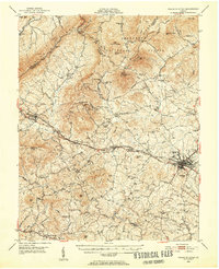
 1951 Moneta1953 Print · USGSMid-century Bedford and Franklin counties are shown here before the inundation of the Roanoke valley. Genealogists and historians can trace the foundations of rural life through landmarks like Davis Mill, the VIRGINIAN rail line, and Emmaus Sch.3 unique versions available
 - 1951 Map of Altavista, 1953 Print
 1951 Altavista1953 Print · USGSThe Roanoke River valley in the early fifties shows a region defined by its rail-and-river economy and tight-knit rural communities. Genealogists and local historians can trace family roots through landmarks like Bethlehem Ch, Lynch Sta, and Greasy Sch.2 unique versions available
 - 1952 Map of Amherst
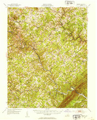
 1952 Amherst1952 Print · USGSAmherst County and the Blue Ridge heights are captured here in the early fifties before modern development reshaped the rural landscape. Genealogists can trace family lines through dozens of local landmarks like Dodds Store, Indian Mission, and Pleasant Grove Ch.
Showing maps 1-25 of 87
Top cities of Bedford County
Frequently asked questions
- What are the different types of historical maps available for Bedford County?
- What is the oldest map of Bedford County?
- Where can I purchase historical maps of Bedford County for my home or office?
- Where can I download high-res historical maps of Bedford County?
- Are there historical topographic maps available for Bedford County?
- Is there historical aerial imagery available for Bedford County?
- Where are historical maps of Bedford County sourced from?