1950s Maps of Brunswick County, Virginia
Explore 9 historic maps of Brunswick County from the 1950s. These maps offer a rare glimpse into what life looked like during the 1950s — showing old roads, neighborhoods, homes, and landmarks that have changed or disappeared over time.
Whether you're researching your family's past, planning a metal detecting trip, or studying how Brunswick County's landscape evolved across the 1950s, these high-resolution maps are a powerful tool for exploring the history of this region.
- Focus on a specific era: All maps on this page are from the 1950s, giving you a focused view of this time period.
- See what’s changed: Compare century-old streets, trails, and buildings to today's modern landscape using overlays and satellite layers.
- Research with precision: Use these maps for genealogy, historical research, land use analysis, or educational projects.
- View, download, or print: Maps are fully viewable online in high resolution, and can be downloaded or printed for your own records.
Start exploring Brunswick County's history through authentic maps from the 1950s. This is your window into the past.
Brunswick County, VA maps
(9)- 1951 Map of Danieltown, 1952 Print
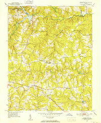 1951 Danieltown1952 Print · USGSMid-century Brunswick County is captured here during a time of rural stability, characterized by the Virginian rail line and family-run crossroads. Researchers can trace ancestral locations through the many named sites like Warrens Store, Rocky Run Church, and Stainback Cem.4 unique versions available
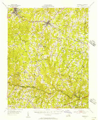
 - 1951 Map of Warfield, 1952 Print
 1951 Warfield1952 Print · USGSBrunswick County in the early fifties shows a rural landscape shaped by the Seaboard Air Line and the winding Nottoway River. Genealogists and historians can trace family-named sites like Baskerville Mill and schools such as Warfield Sch and Graves Sch.4 unique versions available
 - 1953 Map of Norfolk, 1954 Print
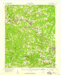
 1953 Norfolk1954 Print · USGSCoastal Virginia and northeastern North Carolina appear here during the post-war industrial boom, showing the critical rail-and-sea connections of Hampton Roads. Genealogists can trace family roots through rural landmarks like Gethsemane Ch, the Caledonia State Prison Farm, and the vast interior of the Dismal Swamp.4 unique versions available
 - 1953 Map of Greensboro, 1981 Print
 1953 Greensboro1981 Print · USGSThe Piedmont borderlands of North Carolina and Virginia show a landscape defined by new reservoirs and old rail lines. Trace family roots and the changing river geography through Elon College, the John H Kerr Reservoir, and South Boston.
 - 1954 Map of Greensboro
 1954 Greensboro1954 Print · USGSThe Piedmont borderlands of North Carolina and Virginia come alive in this mid-fifties study of a region defined by its rivers and rails. Researchers can trace the growing Buggs Island Lake or follow the paths of the Southern Ry and Seaboard Air Line RR through towns like Oxford and Reidsville.
 - 1955 Map of Kenbridge, 1957 Print
 1955 Kenbridge1957 Print · USGSSouthside Virginia's rural heartland thrives in the mid-fifties, shaped by the Virginian railroad and a landscape of crossroads hamlets. Genealogists and local historians can trace family roots through numerous sites like Whittles Mill, St Mark Ch, and Lochleven Sch.
 - 1958 Map of Crewe, 1959 Print
 1958 Crewe1959 Print · USGSNottoway County thrived as a railroad crossroads in the late fifties, centered on the busy rail hubs of Crewe and Burkeville. Researchers can trace old family sites and rural landmarks like the Piedmont Sanatorium, Jennings Ordinary, and Wards Chapel.2 unique versions available
 - 1959 Map of Roanoke
 1959 Roanoke1959 Print · USGSCentral Virginia and the Blue Ridge appear in great detail during the late fifties, showcasing the transition from mountain industry to Piedmont farmland. Trace the path of the Norfolk and Western railroad or find old river towns like Appomattox and Amelia Court House.
 - 1959 Map of Richmond
 1959 Richmond1959 Print · USGSMid-century Virginia is captured here at its most vital rail and river junctions, from the capital city to the Chesapeake Bay. Genealogists and historians can trace the development of colonial settlements like Williamsburg and military landmarks including Fort Monroe and Camp Lee.
End of results
Showing maps 1-9 of 9
Top cities of Brunswick County
Frequently asked questions
- What are the different types of historical maps available for Brunswick County?
- What is the oldest map of Brunswick County?
- Where can I purchase historical maps of Brunswick County for my home or office?
- Where can I download high-res historical maps of Brunswick County?
- Are there historical topographic maps available for Brunswick County?
- Is there historical aerial imagery available for Brunswick County?
- Where are historical maps of Brunswick County sourced from?