1960s Maps of Brunswick County, Virginia
Explore 20 historic maps of Brunswick County from the 1960s. These maps offer a rare glimpse into what life looked like during the 1960s — showing old roads, neighborhoods, homes, and landmarks that have changed or disappeared over time.
Whether you're researching your family's past, planning a metal detecting trip, or studying how Brunswick County's landscape evolved across the 1960s, these high-resolution maps are a powerful tool for exploring the history of this region.
- Focus on a specific era: All maps on this page are from the 1960s, giving you a focused view of this time period.
- See what’s changed: Compare century-old streets, trails, and buildings to today's modern landscape using overlays and satellite layers.
- Research with precision: Use these maps for genealogy, historical research, land use analysis, or educational projects.
- View, download, or print: Maps are fully viewable online in high resolution, and can be downloaded or printed for your own records.
Start exploring Brunswick County's history through authentic maps from the 1960s. This is your window into the past.
Brunswick County, VA maps
(20)- 1962 Map of Greensboro
 1962 Greensboro1962 Print · USGSThe Piedmont region along the Virginia and North Carolina border comes alive in the early 1960s, showing a landscape defined by industry and new reservoirs. Trace the path of the Virginian RR or explore the early development of Greensboro and Durham.
 - 1963 Map of Roanoke
 1963 Roanoke1963 Print · USGSCentral Virginia and the Blue Ridge front appear here in the early sixties, caught between their deep railroad roots and new postwar developments. Genealogists and historians can trace the rail lines of the Norfolk and Western through towns like Bedford and Altavista, or locate family landmarks near Smith Mountain Lake.
 - 1963 Map of Powellton, 1964 Print
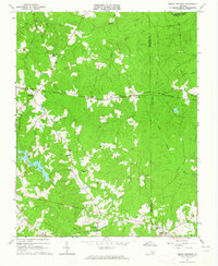
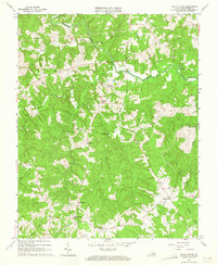
 1963 Powellton1964 Print · USGSBrunswick County in the early sixties reveals a landscape shaped by the Meherrin River and long-standing family settlements. Genealogists can locate numerous rural burial sites and landmarks like Sculthorp Cem, James Square Ch, and Fort Christanna.3 unique versions available
 - 1963 Map of Barley, 1964 Print
 1963 Barley1964 Print · USGSCross the state line between Virginia and North Carolina in the early sixties, where rural life centered on small crossroads like Barley. Genealogists can locate family-named sites like Garners Mill, Royland Sch, and Oak Grove Ch.3 unique versions available
 - 1963 Map of Mc Kenney, 1964 Print
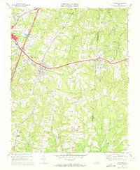
 1963 Mc Kenney1964 Print · USGSDinwiddie County's rural landscape is centered on the railroad town of McKenney in the early 1960s, a time when family-named cemeteries and country churches defined the community. Local history researchers can trace family roots at Asbury Cem, Abernathy Cem, or near the Nottoway River and Cutbank Bridge.2 unique versions available
 - 1963 Map of Alberta, 1964 Print
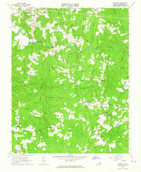
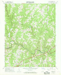
 1963 Alberta1964 Print · USGSVirginia's southern tobacco and timber country is shown here in the early sixties, centered on the rail junctions of Brunswick County. Genealogists and historians can locate rural landmarks like St Pauls Chapel, the Laffoon Cem, and the historic Price Mill on Great Creek.3 unique versions available
 - 1963 Map of Gasburg, 1964 Print
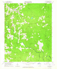
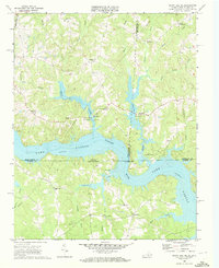
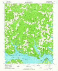 1963 Gasburg1964 Print · USGSThe Virginia and North Carolina borderlands appear in transition during the early sixties as the newly formed Lake Gaston reshapes the landscape. Local historians can trace family roots through numerous sites like Ebony, St Pauls Chapel, and Kirkland Cem.4 unique versions available
 - 1963 Map of Lawrenceville, 1964 Print
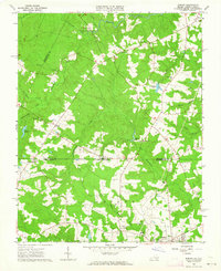
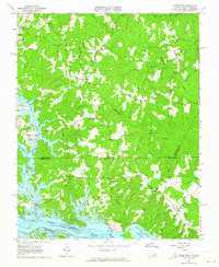
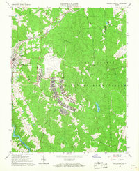
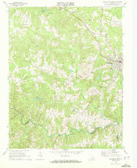
 1963 Lawrenceville1964 Print · USGSBrunswick County at the start of the 1960s is a landscape defined by its rail junctions and academic roots. Genealogists and historians can trace the rail corridors through Alberta and Dolphin or locate family sites like Shart Chapel and St Pauls College.2 unique versions available
 - 1963 Map of Smoky Ordinary, 1964 Print
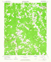
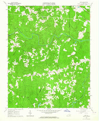
 1963 Smoky Ordinary1964 Print · USGSSouthern Brunswick County appears in the early sixties as a region of small rail stops and country parishes. Genealogists and historians can trace family locations near Smoky Ordinary, Mallory Sch, or the several churches like Emmanuel Ch along the NORFOLK AND WESTERN line.3 unique versions available
 - 1963 Map of Ante, 1964 Print
 1963 Ante1964 Print · USGSBrunswick and Greensville counties in the early sixties remained a landscape of rural crossroads and river bottomlands. Genealogists can locate family landmarks like Hobbs Chapel, the Scott Lewis Sch, and small hamlets such as Totaro and Cordie.3 unique versions available
 - 1963 Map of Valentines, 1964 Print
 1963 Valentines1964 Print · USGSThe Virginia and North Carolina borderlands are captured in the early sixties as the reservoirs of Lake Gaston and Roanoke Rapids Lake shape the landscape. Researchers can trace rural community life through sites like Little Bethel Ch, Vultare, and the Old Railroad Grade.4 unique versions available
 - 1963 Map of White Plains, 1965 Print
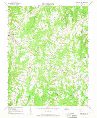
 1963 White Plains1965 Print · USGSBrunswick County in the early sixties remained a landscape of quiet crossroads and riverside settlements. Genealogists can trace family footprints at Flournoy Cem and Taylor Cem, or locate historic gathering places like Hicks Mill and Tabernacle Ch.2 unique versions available
 - 1964 Map of Richmond
 1964 Richmond1964 Print · USGSCoastal and central Virginia are mapped during the mid-twentieth century, showing the critical intersection of rail, river, and military life. Genealogists can trace family roots through rural county seats like Amelia or find vanished coastal neighborhoods near Phoebus and Hilton Village.
 - 1966 Map of Greensboro
 1966 Greensboro1966 Print · USGSThe North Carolina and Virginia Piedmont thrives during the mid-sixties, showcasing a landscape of textile hubs and expanding river reservoirs. Researchers can trace the rail corridors of the Southern Railway, find local landmarks like Elon College, or locate the extensive Camp Butner Military Reservation.
 - 1966 Map of Blackstone East, 1967 Print
 1966 Blackstone East1967 Print · USGSNottoway County during the mid-sixties is captured here, showing the expansion of military training facilities alongside traditional rural life. Genealogists and historians can trace the foundations of Blackstone Army Air Base and locate local landmarks like Spring Hill Ch and the Nottoway Reservoir.5 unique versions available
 - 1966 Map of Forksville, 1968 Print
 1966 Forksville1968 Print · USGSThe rural borderlands of Lunenburg, Mecklenburg, and Brunswick Counties are captured here in the mid-sixties. Local researchers can trace family landmarks like Stones Mill, the community at Forksville, and the Seaboard Coast Line railroad.2 unique versions available
 - 1966 Map of Kenbridge East, 1968 Print
 1966 Kenbridge East1968 Print · USGSLunenburg County in the mid-sixties remained a landscape of rail-side settlements and rural congregations. Genealogists and researchers can trace the tracks of the Norfolk and Western through Kenbridge and Dundas, or locate Fletchers Chapel and Dixon Millpond.3 unique versions available
 - 1968 Map of South Hill SE, 1972 Print
 1968 South Hill SE1972 Print · USGSThe Roanoke River valley is shown transformed by the waters of Lake Gaston in the late sixties as the border region adapted to its new shoreline. Genealogists can trace numerous rural congregations and crossroads, including Barker Crossroads, Five Forks, and Holly Grove Ch.3 unique versions available
 - 1968 Map of Blackstone West, 1972 Print
 1968 Blackstone West1972 Print · USGSBlackstone and the Southside Virginia countryside appear here in the late sixties, a period of transition for the rail-and-river landscape. Genealogists and historians can trace old community landmarks like Vaster High Sch, Lakeview Cemetery, and the Norfolk and Western rail line.3 unique versions available
 - 1968 Map of La Crosse, 1972 Print
 1968 La Crosse1972 Print · USGSMecklenburg County was a bustling rail corridor in the late sixties, centered on the strategic crossing at La Crosse. Genealogists can trace family landmarks like Booker-Boyd Sch and rural congregations at Miles Chapel or Mt Sinai Ch.3 unique versions available
End of results
Showing maps 1-20 of 20
Top cities of Brunswick County
Frequently asked questions
- What are the different types of historical maps available for Brunswick County?
- What is the oldest map of Brunswick County?
- Where can I purchase historical maps of Brunswick County for my home or office?
- Where can I download high-res historical maps of Brunswick County?
- Are there historical topographic maps available for Brunswick County?
- Is there historical aerial imagery available for Brunswick County?
- Where are historical maps of Brunswick County sourced from?