1970s Maps of Brunswick County, Virginia
Explore 6 historic maps of Brunswick County from the 1970s. These maps offer a rare glimpse into what life looked like during the 1970s — showing old roads, neighborhoods, homes, and landmarks that have changed or disappeared over time.
Whether you're researching your family's past, planning a metal detecting trip, or studying how Brunswick County's landscape evolved across the 1970s, these high-resolution maps are a powerful tool for exploring the history of this region.
- Focus on a specific era: All maps on this page are from the 1970s, giving you a focused view of this time period.
- See what’s changed: Compare century-old streets, trails, and buildings to today's modern landscape using overlays and satellite layers.
- Research with precision: Use these maps for genealogy, historical research, land use analysis, or educational projects.
- View, download, or print: Maps are fully viewable online in high resolution, and can be downloaded or printed for your own records.
Start exploring Brunswick County's history through authentic maps from the 1970s. This is your window into the past.
Brunswick County, VA maps
(6)- 1971 Map of Roanoke, 1977 Print
 1971 Roanoke1977 Print · USGSThe Virginia Piedmont and Blue Ridge mountains meet in this early 1970s landscape of river valleys and rail hubs. Researchers can trace historic transportation routes and landmarks like the Appomattox Court House Nat Hist Pk, the Peaks of Otter, and Amelia Court House.2 unique versions available
 - 1973 Map of Richmond, 1974 Print
 1973 Richmond1974 Print · USGSThe Virginia Tidewater and Piedmont come alive in the early seventies, showcasing a region defined by its great rivers and massive military installations. Researchers can trace the mid-century growth of Richmond or locate family sites near Amelia Court House and Highland Springs.2 unique versions available
 - 1976 Map of Valentines, 1979 Print
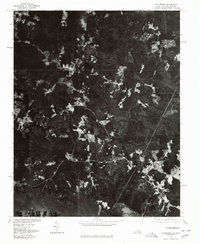 1976 Valentines1979 Print · USGSSpanning the Virginia and North Carolina border in the mid-seventies, this orthophoto captures the rural landscape as Lake Gaston reshaped the southern terrain. Researchers can identify precise field patterns and wooded tracts surrounding Valentines and Triplet.
 - 1977 Map of Gasburg, 1979 Print
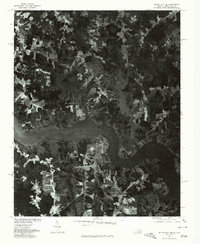
 1977 Gasburg1979 Print · USGSThe Virginia and North Carolina borderlands come into focus in the late seventies as reservoir living begins to shape the rural landscape. Researchers can trace land use patterns around Lake Gaston and the settlements of Gasburg and Ebony.
 - 1977 Map of South Hill SE, 1979 Print
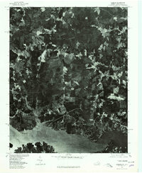
 1977 South Hill SE1979 Print · USGSMecklenburg County and the borderlands of North Carolina come into focus in the late seventies as the shoreline of Lake Gaston reshapes the land. Researchers can trace the development of lakeside tracts near Joyceville and the rural road junctions at Five Forks.
 - 1979 Map of Appomattox, 1982 Print
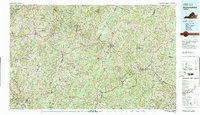 1979 Appomattox1982 Print · USGSSouthside Virginia in the late seventies remains a landscape of historic rail towns and vast state forests. Genealogists and historians can trace the routes of the Norfolk and Western through Farmville or locate ancestral sites near Hampden Sydney and Charlotte Court House.
End of results
Showing maps 1-6 of 6
Top cities of Brunswick County
Frequently asked questions
- What are the different types of historical maps available for Brunswick County?
- What is the oldest map of Brunswick County?
- Where can I purchase historical maps of Brunswick County for my home or office?
- Where can I download high-res historical maps of Brunswick County?
- Are there historical topographic maps available for Brunswick County?
- Is there historical aerial imagery available for Brunswick County?
- Where are historical maps of Brunswick County sourced from?