1960s Maps of Port Royal, Virginia
Explore 3 historic maps of Port Royal from the 1960s. These maps offer a rare glimpse into what life looked like during the 1960s — showing old roads, neighborhoods, homes, and landmarks that have changed or disappeared over time.
Whether you're researching your family's past, planning a metal detecting trip, or studying how Port Royal's landscape evolved across the 1960s, these high-resolution maps are a powerful tool for exploring the history of this region.
- Focus on a specific era: All maps on this page are from the 1960s, giving you a focused view of this time period.
- See what’s changed: Compare century-old streets, trails, and buildings to today's modern landscape using overlays and satellite layers.
- Research with precision: Use these maps for genealogy, historical research, land use analysis, or educational projects.
- View, download, or print: Maps are fully viewable online in high resolution, and can be downloaded or printed for your own records.
Start exploring Port Royal's history through authentic maps from the 1960s. This is your window into the past.
Port Royal, VA maps
(3)- 1961 Map of Washington
 1961 Washington1961 Print · USGSThe mid-Atlantic region in the late fifties is presented in remarkable detail, from the Blue Ridge foothills to the Chesapeake Eastern Shore. Researchers can trace historic river landings and military sites like Mount Vernon, Fort Belvoir, and Point Lookout.2 unique versions available
 - 1964 Map of Port Royal
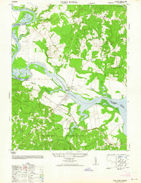 1964 Port Royal1964 Print · USGSMid-century Port Royal and Port Conway anchor this study of the Rappahannock River valley as it appeared before modern development. Genealogists and historians can trace family-named sites like Camden Farm, rural institutions like Welcome School, and the early footprint of the A P Hill Military Reservation.
 - 1968 Map of Port Royal, 1971 Print
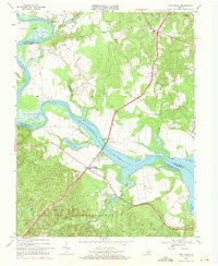 1968 Port Royal1971 Print · USGSPort Royal and the surrounding Virginia tidewater appear here in the late sixties as the James Madison Memorial Bridge connects the river towns. Researchers can trace family sites near Port Conway, Emmanuel Ch, and the Camp Hill Military Reservation.5 unique versions available
End of results
Showing maps 1-3 of 3
Top cities near Port Royal
- King George historical maps
- Colonial Beach historical maps
- Dahlgren historical maps
- Passapatanzy historical maps
- Bowling Green historical maps
- Dahlgren Center historical maps
See more
Frequently asked questions
- What are the different types of historical maps available for Port Royal?
- What is the oldest map of Port Royal?
- Where can I purchase historical maps of Port Royal for my home or office?
- Where can I download high-res historical maps of Port Royal?
- Are there historical topographic maps available for Port Royal?
- Is there historical aerial imagery available for Port Royal?
- Where are historical maps of Port Royal sourced from?