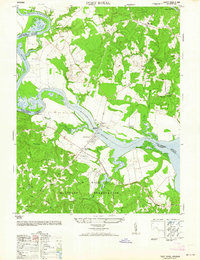
1964 Map of Port Royal
USGS Topo · Published 1964About this map
Port Royal and Port Conway face one another across the Rappahannock River, linked by the James Madison Memorial Bridge at the center of this 1950s-era military reprint. The landscape south of the river is dominated by the sprawling boundaries of the A P Hill Military Reservation, where features like Hill Airstrip No 2 and Millers Pond sit within the restricted terrain. North of the river, in King George County, the map reveals a traditional rural settlement pattern with several country churches, including Union Church and Salem Church, and the Welcome School near Jersey. This survey captures the transition of the region from a purely agricultural and river-based economy to one significantly shaped by the presence of a major military installation. Local family landmarks like Camden Farm and Hazelwood persist near the riverbank, contrasting with the tactical roads of the reservation.
Find a feature on this map
29 named features on this map. Tap any name to fly to it.
Don’t see what you’re looking for? This feature index may not catch every label — zoom into the map to look around manually.
Map Details
Editions of this 1964 Port Royal Map
This is the sole edition of this map. No revisions or reprints were ever made.
Other maps of this area

1889 · Fredericksburg
USGS Topo · 1:125,000

1892 · Fredericksburg
USGS Topo · 1:125,000

1894 · Fredericksburg
USGS Topo · 1:125,000

1926 · Stafford
USGS Topo · 1:62,500

1931 · Stafford
USGS Topo · 1:62,500

1942 · Bowling Green
USGS Topo · 1:31,680

1942 · Upper Zion
USGS Topo · 1:31,680

1942 · Occupacia
USGS Topo · 1:31,680

1942 · Rollins Fork
USGS Topo · 1:31,680

1942 · Port Royal
USGS Topo · 1:31,680