1940s Maps of Wrightsville, Virginia
Explore 3 historic maps of Wrightsville from the 1940s. These maps offer a rare glimpse into what life looked like during the 1940s — showing old roads, neighborhoods, homes, and landmarks that have changed or disappeared over time.
Whether you're researching your family's past, planning a metal detecting trip, or studying how Wrightsville's landscape evolved across the 1940s, these high-resolution maps are a powerful tool for exploring the history of this region.
- Focus on a specific era: All maps on this page are from the 1940s, giving you a focused view of this time period.
- See what’s changed: Compare century-old streets, trails, and buildings to today's modern landscape using overlays and satellite layers.
- Research with precision: Use these maps for genealogy, historical research, land use analysis, or educational projects.
- View, download, or print: Maps are fully viewable online in high resolution, and can be downloaded or printed for your own records.
Start exploring Wrightsville's history through authentic maps from the 1940s. This is your window into the past.
Wrightsville, VA maps
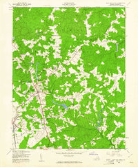
(3)- 1942 Map of Bowling Green
 1942 Bowling Green1942 Print · USGSCaroline County is shown during its wartime expansion in the 1940s as military boundaries reshaped traditional rural life. Researchers can trace the intersection of new defense infrastructure like the C A A Emergency Landing Field with historic locales such as Broaddus Mill and Poorhouse Corner.
 - 1948 Map of Washington
 1948 Washington1948 Print · USGSThe Potomac and Chesapeake regions in the late 1940s reveal a landscape of expanding military reach and deep-rooted Tidewater settlements. Trace old rail corridors like the Richmond Fredericksburg & Potomac RR or locate landmarks like the Wakefield Washington Monument and St. Marys College.2 unique versions available
 - 1949 Map of Bowling Green, 1961 Print
 1949 Bowling Green1961 Print · USGSCaroline County in the late 1940s displays a mix of traditional milling and the growing footprint of the A P Hill Military Reservation. Researchers can trace family-named corners and local industry at Hicks Mill, Elliots Pond, and the Milford rail stop.2 unique versions available
End of results
Showing maps 1-3 of 3
Top cities near Wrightsville
- King George historical maps
- Lake Land'Or historical maps
- Lake Caroline historical maps
- Bowling Green historical maps
- Port Royal historical maps
Frequently asked questions
- What are the different types of historical maps available for Wrightsville?
- What is the oldest map of Wrightsville?
- Where can I purchase historical maps of Wrightsville for my home or office?
- Where can I download high-res historical maps of Wrightsville?
- Are there historical topographic maps available for Wrightsville?
- Is there historical aerial imagery available for Wrightsville?
- Where are historical maps of Wrightsville sourced from?