1960s Maps of Charles City County, Virginia
Explore 11 historic maps of Charles City County from the 1960s. These maps offer a rare glimpse into what life looked like during the 1960s — showing old roads, neighborhoods, homes, and landmarks that have changed or disappeared over time.
Whether you're researching your family's past, planning a metal detecting trip, or studying how Charles City County's landscape evolved across the 1960s, these high-resolution maps are a powerful tool for exploring the history of this region.
- Focus on a specific era: All maps on this page are from the 1960s, giving you a focused view of this time period.
- See what’s changed: Compare century-old streets, trails, and buildings to today's modern landscape using overlays and satellite layers.
- Research with precision: Use these maps for genealogy, historical research, land use analysis, or educational projects.
- View, download, or print: Maps are fully viewable online in high resolution, and can be downloaded or printed for your own records.
Start exploring Charles City County's history through authentic maps from the 1960s. This is your window into the past.
Charles City County, VA maps
(11)- 1964 Map of Richmond
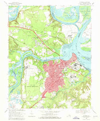
 1964 Richmond1964 Print · USGSCoastal and central Virginia are mapped during the mid-twentieth century, showing the critical intersection of rail, river, and military life. Genealogists can trace family roots through rural county seats like Amelia or find vanished coastal neighborhoods near Phoebus and Hilton Village.
 - 1965 Map of Norge, 1967 Print
 1965 Norge1967 Print · USGSJames City County in the mid-1960s is a landscape of tidal river systems and quiet crossroads settlements. Genealogists and local historians can trace family locations near Norge, Lightfoot, and Jamestown Farms, or locate old landmarks like Warren Mill and Shipyard Landing.3 unique versions available
 - 1965 Map of Charles City, 1967 Print
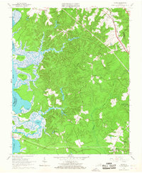
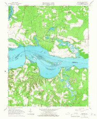
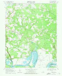
 1965 Charles City1967 Print · USGSThe James River landscape south of Richmond appears here in the mid-1960s, documenting historic riverside estates and colonial tracts. Researchers can trace the grounds of Flowerdew Hundred, locate Blanks Tavern, and find family names at Elam Cem.4 unique versions available
 - 1965 Map of Roxbury, 1967 Print
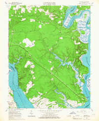
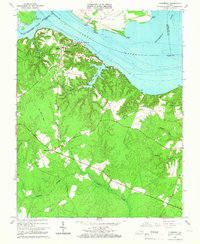
 1965 Roxbury1967 Print · USGSIn the mid-sixties, the Virginia Peninsula landscape around the Charles City and Henrico border remained a rural mosaic of timber and small farms. Genealogists and historians can trace family locations near Glendale National Cemetery, Nance, and the historic Ednas Mill.5 unique versions available
 - 1965 Map of Brandon, 1967 Print
 1965 Brandon1967 Print · USGSCoastal Virginia during the mid-sixties reveals a landscape of tidal marshes and riverfront settlements between the James and Chickahominy. Genealogists and historians can locate rural landmarks like Jerusalem Ch, the settlement of Holdcroft, and landing points at Brandon Point.3 unique versions available
 - 1965 Map of Westover, 1967 Print
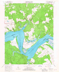
 1965 Westover1967 Print · USGSThe James River corridor in the mid-sixties reveals a landscape of historic landings and rural crossroads. Genealogists can locate family landmarks like Merchant Hope Ch, Rolands Mill, and the riverside grounds of Westover.3 unique versions available
 - 1965 Map of Walkers, 1968 Print
 1965 Walkers1968 Print · USGSCoastal Virginia in the mid-sixties reveals a landscape shaped by the winding Chickahominy River and the newly formed reservoir. Genealogists and historians can trace riverside landmarks like Osborn Landing, Tsena Commoko Ch, and the Chesapeake and Ohio rail line.4 unique versions available
 - 1966 Map of Claremont
 1966 Claremont1966 Print · USGSThe James River shoreline and Surry County interior are captured here during the mid-sixties as the region maintained its rural character. Genealogists and historians can locate family landmarks such as Claremont Manor, the Mercy Seat Ch, and remnants of an Old Railroad Grade.4 unique versions available
 - 1966 Map of Providence Forge, 1968 Print
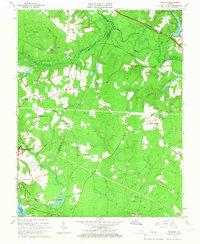
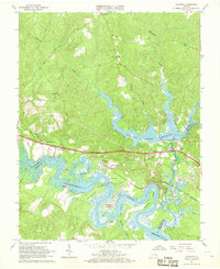
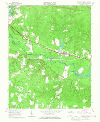 1966 Providence Forge1968 Print · USGSThe rural landscape of New Kent and Charles City counties is documented here in the mid-1960s. Researchers can locate vanished landmarks like Adkins Store and Roaches Corner, or trace family roots through numerous local churches including Emmaus Ch and Mt Stirling Ch.4 unique versions available
 - 1969 Map of Hopewell, 1971 Print
 1969 Hopewell1971 Print · USGSCoastal Virginia during the late sixties shows a mix of industrial growth and military presence at the historic river forks. Genealogists and historians can trace family-named sites like Birchett Estate, visit Bermuda Hundred, or locate local landmarks such as Enon Ch and Woodlawn Sch.4 unique versions available
 - 1969 Map of Dutch Gap, 1971 Print
 1969 Dutch Gap1971 Print · USGSHenrico County in the late sixties shows a landscape where Civil War earthworks meet the jet age at Byrd Field. Genealogists and historians can locate Curles Neck Plantation, the Washington Memorial Cem, and Fort Harrison.4 unique versions available
End of results
Showing maps 1-11 of 11
Top cities of Charles City County
Frequently asked questions
- What are the different types of historical maps available for Charles City County?
- What is the oldest map of Charles City County?
- Where can I purchase historical maps of Charles City County for my home or office?
- Where can I download high-res historical maps of Charles City County?
- Are there historical topographic maps available for Charles City County?
- Is there historical aerial imagery available for Charles City County?
- Where are historical maps of Charles City County sourced from?