1990s Maps of Culpeper County, Virginia
Explore 9 historic maps of Culpeper County from the 1990s. These maps offer a rare glimpse into what life looked like during the 1990s — showing old roads, neighborhoods, homes, and landmarks that have changed or disappeared over time.
Whether you're researching your family's past, planning a metal detecting trip, or studying how Culpeper County's landscape evolved across the 1990s, these high-resolution maps are a powerful tool for exploring the history of this region.
- Focus on a specific era: All maps on this page are from the 1990s, giving you a focused view of this time period.
- See what’s changed: Compare century-old streets, trails, and buildings to today's modern landscape using overlays and satellite layers.
- Research with precision: Use these maps for genealogy, historical research, land use analysis, or educational projects.
- View, download, or print: Maps are fully viewable online in high resolution, and can be downloaded or printed for your own records.
Start exploring Culpeper County's history through authentic maps from the 1990s. This is your window into the past.
Culpeper County, VA maps
(9)- 1994 Map of Castleton, 1997 Print
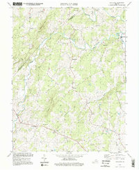 1994 Castleton1997 Print · USGSCulpeper and Rappahannock counties remained deeply rooted in their agricultural traditions during the 1990s, centered on the Hazel River valley. Genealogists and local historians can trace family locations near Monumental Mills, Griffinsburg, and several rural churches like Good Hope Ch.3 unique versions available
 - 1994 Map of Massies Corner, 1997 Print
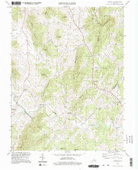
 1994 Massies Corner1997 Print · USGSThe Virginia Piedmont of the mid-nineties is captured here at the intersection of three counties, showing a landscape defined by river valleys and prominent peaks. Researchers can locate community anchors like Battle Run Ch, the Drive-in Theater at Massies Corner, and the small settlement of Laurel Mills.
 - 1994 Map of Woodville, 1997 Print
 1994 Woodville1997 Print · USGSThe foothills of the Blue Ridge in the mid-1990s reveal a landscape of ancestral mountain peaks and riverbank milling communities. Genealogists can locate family landmarks like Revercombs Corner or trace the rural parishes of Piedmont Ch and Nazareth Ch.2 unique versions available
 - 1994 Map of Salem Church, 1997 Print
 1994 Salem Church1997 Print · USGSSpotsylvania County in the mid-1990s reveals a unique intersection of Civil War preservation and modern suburban growth. Genealogists and historians can trace old road networks like Plank Road through crossroads at Chancellor and Fivemile Fork.
 - 1994 Map of Warrenton, 1999 Print
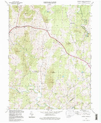
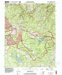
 1994 Warrenton1999 Print · USGSWarrenton and its surrounding Fauquier County landscapes are captured here in the late twentieth century as the area transitioned from rural life to a growing hub. Researchers can locate local landmarks like Fauquier White Sulphur Springs, St Johns Sch, and the quiet woods of Whitney State Forest.
 - 1994 Map of Culpeper East, 1999 Print
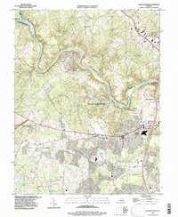
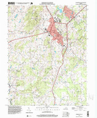
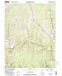
 1994 Culpeper East1999 Print · USGSCulpeper and the historic fields of Brandy Station are captured here in the mid-nineties, showing the mix of growing town life and rural heritage. Genealogists and historians can trace local landmarks like Mount Pony, the National Cem, and churches such as Cedar Grove Ch.
 - 1994 Map of Chancellorsville, 1999 Print
 1994 Chancellorsville1999 Print · USGSSpotsylvania County in the mid-1990s reflects a landscape defined by Civil War memory and modern residential growth. Genealogists and historians can locate markers like the Jackson Monument and Hays Monument alongside settlements such as Wilderness Corner and Cookstown.
 - 1997 Map of Culpeper West, 1999 Print
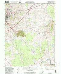
 1997 Culpeper West1999 Print · USGSCulpeper and its western rural surroundings are captured in the late 1990s as the town expanded toward the Piedmont hills. Researchers can trace historic settlements and local landmarks like Waylands Mill, Rising Zion Ch, and the tracks of the Southern railroad.
 - 1998 Map of Richardsville, 2001 Print
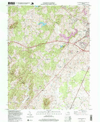
 1998 Richardsville2001 Print · USGSThe confluence region of Fauquier and Culpeper counties is captured here in the late twentieth century, centered on the river-fed landscape near Richardsville. Researchers can trace the rural layout of communities like Goldvein and Sumerduck or locate family sites near Union Ch.
End of results
Showing maps 1-9 of 9
Top cities of Culpeper County
Frequently asked questions
- What are the different types of historical maps available for Culpeper County?
- What is the oldest map of Culpeper County?
- Where can I purchase historical maps of Culpeper County for my home or office?
- Where can I download high-res historical maps of Culpeper County?
- Are there historical topographic maps available for Culpeper County?
- Is there historical aerial imagery available for Culpeper County?
- Where are historical maps of Culpeper County sourced from?