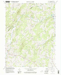
1994 Map of Castleton
USGS Topo · Published 1997About this map
Thornton River and the Hazel River converge in this Piedmont landscape, defining the rural character of the Rappahannock and Culpeper county line. The terrain is marked by prominent elevations like Castleton Mtn and Scott Mountain, with small settlements such as Castleton, Eldorado, and Norman serving as local hubs. The area is dotted with numerous country houses of worship, including Gourdvine Ch and Black Oak Ch, alongside community landmarks like Monumental Mills and the Thornton River Camp. A network of creeks and runs, such as Blackwater Creek and Muddy Run, crisscrosses the farmland and wooded slopes. This 1994 update of mid-century topography reveals a persistent agricultural pattern, where the winding watercourses dictated the placement of historic cemeteries and the orientation of old rural roads.
Find a feature on this map
38 named features on this map. Tap any name to fly to it.
Don’t see what you’re looking for? This feature index may not catch every label — zoom into the map to look around manually.
Map Details
Editions of this 1994 Castleton Map
3 editions found
Other maps of this area

1887 · Spottsylvania
USGS Topo · 1:125,000

1892 · Spottsylvania
USGS Topo · 1:125,000

1892 · Gordonsville
USGS Topo · 1:125,000

1893 · Luray
USGS Topo · 1:125,000

1894 · Warrenton
USGS Topo · 1:125,000

1894 · Warrenton
USGS Topo · 1:62,500

1905 · Luray
USGS Topo · 1:125,000

1927 · Remington
USGS Topo · 1:48,000

1930 · Warrenton
USGS Topo · 1:62,500

1943 · Culpeper
USGS Topo · 1:24,000