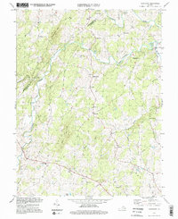
1994 Map of Castleton
USGS Topo · Published 1997About this map
The Hazel River and Thornton River carve through the foothills of the Blue Ridge, defining a landscape of traditional Piedmont agriculture and small upland settlements. While the topography was compiled in 1959, the 1994 photoinspection maintains a record of long-standing community centers like Eggbornsville, Eldorada, and Griffinsburg. The map reveals a high density of rural institutions that served these farming communities, including numerous country churches such as Gourdvine Ch, Beulah Ch, and New Salem Ch.
Find a feature on this map
37 named features on this map. Tap any name to fly to it.
Don’t see what you’re looking for? This feature index may not catch every label — zoom into the map to look around manually.
Map Details
Editions of this 1994 Castleton Map
3 editions found
Other maps of this area

1887 · Spottsylvania
USGS Topo · 1:125,000

1892 · Spottsylvania
USGS Topo · 1:125,000

1892 · Gordonsville
USGS Topo · 1:125,000

1893 · Luray
USGS Topo · 1:125,000

1894 · Warrenton
USGS Topo · 1:125,000

1894 · Warrenton
USGS Topo · 1:62,500

1905 · Luray
USGS Topo · 1:125,000

1927 · Remington
USGS Topo · 1:48,000

1930 · Warrenton
USGS Topo · 1:62,500

1943 · Culpeper
USGS Topo · 1:24,000