
1930 Map of Warrenton
USGS Topo · Published 1930About this map
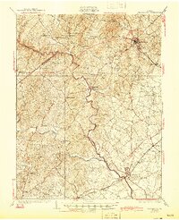
The Rappahannock River serves as a winding border between Fauquier and Culpeper counties on this 1930 map. The landscape is dotted with early twentieth-century community anchors, from the Fauquier White Sulphur Springs resort area to a dense network of local schoolhouses like Clover Hill Sch and Piney Ridge Sch. Local industrial activity is evidenced by Orlean Mills and Corn Mills, while the Southern railroad provides a critical transportation corridor through the eastern half of the quadrangle, linking Warrenton with southern settlements. This survey reflects a predominantly rural economy where family-named runs, such as Thumb Run and Carter Run, define the drainage of the Piedmont terrain. Genealogists may find value in the specific placement of numerous rural churches, including Wesley Chapel and Jetersburg Ch, which served these dispersed farming communities.
Find a feature on this map
67 named features on this map. Tap any name to fly to it.
Don’t see what you’re looking for? This feature index may not catch every label — zoom into the map to look around manually.
Map Details
Editions of this 1930 Warrenton Map
2 editions found
Other maps of this area

1887 · Spottsylvania
USGS Topo · 1:125,000

1892 · Spottsylvania
USGS Topo · 1:125,000

1892 · Gordonsville
USGS Topo · 1:125,000

1893 · Luray
USGS Topo · 1:125,000

1894 · Warrenton
USGS Topo · 1:125,000

1894 · Warrenton
USGS Topo · 1:62,500

1905 · Luray
USGS Topo · 1:125,000

1927 · Remington
USGS Topo · 1:48,000

1933 · Middleburg
USGS Topo · 1:62,500

1939 · Front Royal
USGS Topo · 1:48,000