1960s Maps of Tysons, Virginia
Explore 3 historic maps of Tysons from the 1960s. These maps offer a rare glimpse into what life looked like during the 1960s — showing old roads, neighborhoods, homes, and landmarks that have changed or disappeared over time.
Whether you're researching your family's past, planning a metal detecting trip, or studying how Tysons's landscape evolved across the 1960s, these high-resolution maps are a powerful tool for exploring the history of this region.
- Focus on a specific era: All maps on this page are from the 1960s, giving you a focused view of this time period.
- See what’s changed: Compare century-old streets, trails, and buildings to today's modern landscape using overlays and satellite layers.
- Research with precision: Use these maps for genealogy, historical research, land use analysis, or educational projects.
- View, download, or print: Maps are fully viewable online in high resolution, and can be downloaded or printed for your own records.
Start exploring Tysons's history through authentic maps from the 1960s. This is your window into the past.
Tysons, VA maps
(3)- 1961 Map of Washington
 1961 Washington1961 Print · USGSThe mid-Atlantic region in the late fifties is presented in remarkable detail, from the Blue Ridge foothills to the Chesapeake Eastern Shore. Researchers can trace historic river landings and military sites like Mount Vernon, Fort Belvoir, and Point Lookout.2 unique versions available
 - 1965 Map of Falls Church, 1966 Print
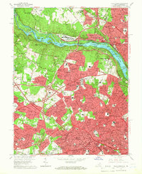 1965 Falls Church1966 Print · USGSFairfax County and Montgomery County are shown here during a period of massive suburban growth in the mid-sixties. Genealogists and local historians can trace the development of McLean and Falls Church while locating landmarks like the Clara Barton House and the Washington and Old Dominion rail line.5 unique versions available
 - 1966 Map of Vienna, 1967 Print
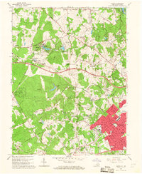 1966 Vienna1967 Print · USGSFairfax County underwent rapid transformation in the mid-sixties as planned communities like Reston emerged alongside the Dulles Airport Road. Genealogists and local historians can trace the foundations of Lake Anne Village, find family landmarks like Browns Chapel Cem, or follow the path of the Washington and Old Dominion Railroad.2 unique versions available
End of results
Showing maps 1-3 of 3
Top cities near Tysons
- Washington historical maps
- Arlington historical maps
- Alexandria historical maps
- Silver Spring historical maps
- Centreville historical maps
- Gaithersburg historical maps
See more
Top neighborhoods of Tysons
- Old Courthouse historical maps
- Tysons Green historical maps
- Ash Grove historical maps
- Madrillon Farms historical maps
Frequently asked questions
- What are the different types of historical maps available for Tysons?
- What is the oldest map of Tysons?
- Where can I purchase historical maps of Tysons for my home or office?
- Where can I download high-res historical maps of Tysons?
- Are there historical topographic maps available for Tysons?
- Is there historical aerial imagery available for Tysons?
- Where are historical maps of Tysons sourced from?