1990s Maps of Tysons, Virginia
Explore 2 historic maps of Tysons from the 1990s. These maps offer a rare glimpse into what life looked like during the 1990s — showing old roads, neighborhoods, homes, and landmarks that have changed or disappeared over time.
Whether you're researching your family's past, planning a metal detecting trip, or studying how Tysons's landscape evolved across the 1990s, these high-resolution maps are a powerful tool for exploring the history of this region.
- Focus on a specific era: All maps on this page are from the 1990s, giving you a focused view of this time period.
- See what’s changed: Compare century-old streets, trails, and buildings to today's modern landscape using overlays and satellite layers.
- Research with precision: Use these maps for genealogy, historical research, land use analysis, or educational projects.
- View, download, or print: Maps are fully viewable online in high resolution, and can be downloaded or printed for your own records.
Start exploring Tysons's history through authentic maps from the 1990s. This is your window into the past.
Tysons, VA maps
(2)- 1994 Map of Falls Church, 1998 Print
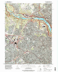 1994 Falls Church1998 Print · USGSNorthern Virginia and Maryland meet at the Potomac in the mid-nineties as suburban growth surrounds historic river crossings. Genealogists and researchers can trace the W & O D Trail, find the Abandoned Gold Mine near the falls, or locate family sites near Walker Chapel and Swinks Mill.
 - 1994 Map of Vienna, 1998 Print
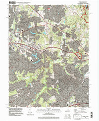 1994 Vienna1998 Print · USGSFairfax County in the mid-nineties shows a mix of rapidly growing suburbs and preserved historical corridors. Trace the evolution of old crossroads at Clarks Crossing and Crowells Corner alongside landmarks like the Colvin Run Mill and Vale Ch.
End of results
Showing maps 1-2 of 2
Top cities near Tysons
- Washington historical maps
- Arlington historical maps
- Alexandria historical maps
- Silver Spring historical maps
- Centreville historical maps
- Gaithersburg historical maps
See more
Top neighborhoods of Tysons
- Old Courthouse historical maps
- Tysons Green historical maps
- Ash Grove historical maps
- Madrillon Farms historical maps
Frequently asked questions
- What are the different types of historical maps available for Tysons?
- What is the oldest map of Tysons?
- Where can I purchase historical maps of Tysons for my home or office?
- Where can I download high-res historical maps of Tysons?
- Are there historical topographic maps available for Tysons?
- Is there historical aerial imagery available for Tysons?
- Where are historical maps of Tysons sourced from?