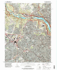
1994 Map of Falls Church
USGS Topo · Published 1998About this map
The Potomac River carves a dramatic path between Fairfax Co and Montgomery Co in this mid-1990s record of Northern Virginia's suburban evolution. The landscape transitions from the preserved natural riverfront of Great Falls Park and the Chesapeake and Ohio Canal to the densely developed residential and commercial corridors of Falls Church and McLean. A legacy of industrial history persists at the Abandoned Gold Mine near Great Falls, while the Naval Ship Research and Development Center stands as a prominent fixture on the Maryland shore.
Find a feature on this map
189 named features on this map. Tap any name to fly to it.
Don’t see what you’re looking for? This feature index may not catch every label — zoom into the map to look around manually.
Map Details
Editions of this 1994 Falls Church Map
This is the sole edition of this map. No revisions or reprints were ever made.
Other maps of this area

1890 · Mt. Vernon
USGS Topo · 1:125,000

1891 · Mt. Vernon
USGS Topo · 1:125,000

1893 · Frederick
USGS Topo · 1:125,000

1894 · Frederick
USGS Topo · 1:125,000

1894 · Mt. Vernon
USGS Topo · 1:125,000

1897 · Mt. Vernon
USGS Topo · 1:125,000

1900 · Washington
USGS Topo · 1:62,500

1908 · Rockville
USGS Topo · 1:62,500

1908 · Seneca
USGS Topo · 1:62,500

1915 · Fairfax
USGS Topo · 1:62,500