
1900 Map of Washington
USGS Topo · Published 1900About this map
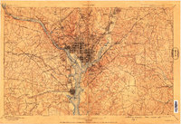
The Potomac River and Anacostia River anchor this turn-of-the-century map of the capital region, revealing the dense street grids of the District alongside the developing suburbs of Maryland and Virginia. To the west, the Chesapeake and Ohio Canal parallels the river from Great Falls down toward the city center. The Virginia shoreline is marked by prominent military and civic sites, including Arlington National Cemetery, Fort Myer, and the rail hub at Arlington Junction. Transportation infrastructure is highly detailed, featuring the Aqueduct Bridge and Long Bridge connecting the capital to Rosslyn and Jackson City. Outside the core, the landscape is dotted with early academic and institutional landmarks such as the Maryland Agril. College and the Theological Seminary. Rural turnpikes like the Leesburg and Georgetown Turnpike and Little River Turnpike radiate outward, tracing the early paths of regional growth.
Find a feature on this map
193 named features on this map. Tap any name to fly to it.
Don’t see what you’re looking for? This feature index may not catch every label — zoom into the map to look around manually.
Map Details
Editions of this 1900 Washington Map
2 editions found
Other maps of this area

1890 · Mt. Vernon
USGS Topo · 1:125,000

1891 · Mt. Vernon
USGS Topo · 1:125,000

1892 · Laurel
USGS Topo · 1:62,500

1892 · Prince Frederick
USGS Topo · 1:62,500

1892 · Brandywine
USGS Topo · 1:62,500

1892 · Owensville
USGS Topo · 1:62,500

1893 · Frederick
USGS Topo · 1:125,000

1894 · Laurel
USGS Topo · 1:62,500

1894 · Frederick
USGS Topo · 1:125,000

1894 · Relay
USGS Topo · 1:62,500