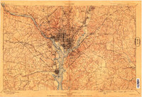
1900 Map of Washington
USGS Topo · Published 1909About this map
The confluence of the Potomac River and Anacostia River forms the center of this detailed turn-of-the-century topographic record, showing the federal district and its surrounding counties before the major urban expansion of the 20th century. Extensive infrastructure like the Chesapeake and Ohio Canal and the Leesburg and Georgetown Turnpike illustrate the era's vital transportation corridors. The map highlights key institutional landmarks such as the Maryland Agril. College, the Naval Observatory, and the Soldiers Home Park, which dominate the landscape outside the core city grid.
Find a feature on this map
225 named features on this map. Tap any name to fly to it.
Don’t see what you’re looking for? This feature index may not catch every label — zoom into the map to look around manually.
Map Details
Editions of this 1900 Washington Map
2 editions found

Other maps of this area

1890 · Mt. Vernon
USGS Topo · 1:125,000

1891 · Mt. Vernon
USGS Topo · 1:125,000

1892 · Laurel
USGS Topo · 1:62,500

1892 · Prince Frederick
USGS Topo · 1:62,500

1892 · Brandywine
USGS Topo · 1:62,500

1892 · Owensville
USGS Topo · 1:62,500

1893 · Frederick
USGS Topo · 1:125,000

1894 · Laurel
USGS Topo · 1:62,500

1894 · Frederick
USGS Topo · 1:125,000

1894 · Relay
USGS Topo · 1:62,500