1970s Maps of Franklin County, Virginia
Explore 5 historic maps of Franklin County from the 1970s. These maps offer a rare glimpse into what life looked like during the 1970s — showing old roads, neighborhoods, homes, and landmarks that have changed or disappeared over time.
Whether you're researching your family's past, planning a metal detecting trip, or studying how Franklin County's landscape evolved across the 1970s, these high-resolution maps are a powerful tool for exploring the history of this region.
- Focus on a specific era: All maps on this page are from the 1970s, giving you a focused view of this time period.
- See what’s changed: Compare century-old streets, trails, and buildings to today's modern landscape using overlays and satellite layers.
- Research with precision: Use these maps for genealogy, historical research, land use analysis, or educational projects.
- View, download, or print: Maps are fully viewable online in high resolution, and can be downloaded or printed for your own records.
Start exploring Franklin County's history through authentic maps from the 1970s. This is your window into the past.
Franklin County, VA maps
(5)- 1971 Map of Roanoke, 1977 Print
 1971 Roanoke1977 Print · USGSThe Virginia Piedmont and Blue Ridge mountains meet in this early 1970s landscape of river valleys and rail hubs. Researchers can trace historic transportation routes and landmarks like the Appomattox Court House Nat Hist Pk, the Peaks of Otter, and Amelia Court House.2 unique versions available
 - 1977 Map of Bent Mountain, 1983 Print
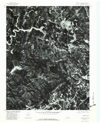
 1977 Bent Mountain1983 Print · USGSThe Roanoke outskirts meet the high ridges of the Blue Ridge during the late seventies, showing the push of suburban development into the mountains. Trace old settlement patterns at Poages Mill and Naff or follow the headwaters of the Blackwater River.
 - 1977 Map of Philpott Lake, 1983 Print
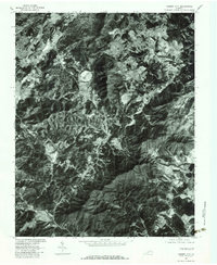
 1977 Philpott Lake1983 Print · USGSFranklin County's landscape in the late seventies is captured here through aerial photography, showing the region's wooded ridges and deep waters. Trace the winding shores of Philpott Lake and locate old crossroads near Prilliman and Philpott.
 - 1977 Map of Smith Mountain Dam, 1983 Print
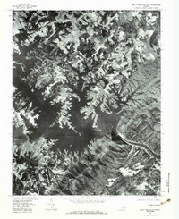 1977 Smith Mountain Dam1983 Print · USGSBedford County's river valleys are captured here in the late seventies, showing the expansive waters behind Smith Mountain Dam. Researchers can trace the rural landscape around Dundee and Kasey or locate family landmarks like Graves Store.
 - 1977 Map of Garden City, 1983 Print
 1977 Garden City1983 Print · USGSThe Roanoke valley and the southern Blue Ridge foothills are captured in detail during the late seventies. Researchers can trace the development of outlying communities like Garden City, Cave Spring, and Starkey against the backdrop of Buck Mountain.
End of results
Showing maps 1-5 of 5
Top cities of Franklin County
- Rocky Mount historical maps
- North Shore historical maps
- Westlake Corner historical maps
- Union Hall historical maps
- Henry Fork historical maps
- Penhook historical maps
See more
Frequently asked questions
- What are the different types of historical maps available for Franklin County?
- What is the oldest map of Franklin County?
- Where can I purchase historical maps of Franklin County for my home or office?
- Where can I download high-res historical maps of Franklin County?
- Are there historical topographic maps available for Franklin County?
- Is there historical aerial imagery available for Franklin County?
- Where are historical maps of Franklin County sourced from?