1990s Maps of Franklin County, Virginia
Explore 2 historic maps of Franklin County from the 1990s. These maps offer a rare glimpse into what life looked like during the 1990s — showing old roads, neighborhoods, homes, and landmarks that have changed or disappeared over time.
Whether you're researching your family's past, planning a metal detecting trip, or studying how Franklin County's landscape evolved across the 1990s, these high-resolution maps are a powerful tool for exploring the history of this region.
- Focus on a specific era: All maps on this page are from the 1990s, giving you a focused view of this time period.
- See what’s changed: Compare century-old streets, trails, and buildings to today's modern landscape using overlays and satellite layers.
- Research with precision: Use these maps for genealogy, historical research, land use analysis, or educational projects.
- View, download, or print: Maps are fully viewable online in high resolution, and can be downloaded or printed for your own records.
Start exploring Franklin County's history through authentic maps from the 1990s. This is your window into the past.
Franklin County, VA maps
(2)- 1996 Map of Bent Mountain, 2000 Print
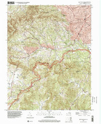 1996 Bent Mountain2000 Print · USGSThe high ridges of Roanoke County and the winding Blue Ridge Parkway are captured here in the mid-nineties. Researchers can locate family landmarks like Lancaster Cem, old rural centers such as Poages Mill, and the Bent Mountain P O.
 - 1999 Map of Garden City, 2000 Print
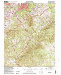 1999 Garden City2000 Print · USGSThe Roanoke suburbs and the Blue Ridge heights met in the late 1990s as development pushed toward the mountains. Genealogists can trace family heritage through numerous hillside cemeteries like Hogan Cem and Bandys Cem or landmarks near Starkey.
End of results
Showing maps 1-2 of 2
Top cities of Franklin County
- Rocky Mount historical maps
- North Shore historical maps
- Westlake Corner historical maps
- Union Hall historical maps
- Henry Fork historical maps
- Penhook historical maps
See more
Frequently asked questions
- What are the different types of historical maps available for Franklin County?
- What is the oldest map of Franklin County?
- Where can I purchase historical maps of Franklin County for my home or office?
- Where can I download high-res historical maps of Franklin County?
- Are there historical topographic maps available for Franklin County?
- Is there historical aerial imagery available for Franklin County?
- Where are historical maps of Franklin County sourced from?