1990s Maps of Giles County, Virginia
Explore 6 historic maps of Giles County from the 1990s. These maps offer a rare glimpse into what life looked like during the 1990s — showing old roads, neighborhoods, homes, and landmarks that have changed or disappeared over time.
Whether you're researching your family's past, planning a metal detecting trip, or studying how Giles County's landscape evolved across the 1990s, these high-resolution maps are a powerful tool for exploring the history of this region.
- Focus on a specific era: All maps on this page are from the 1990s, giving you a focused view of this time period.
- See what’s changed: Compare century-old streets, trails, and buildings to today's modern landscape using overlays and satellite layers.
- Research with precision: Use these maps for genealogy, historical research, land use analysis, or educational projects.
- View, download, or print: Maps are fully viewable online in high resolution, and can be downloaded or printed for your own records.
Start exploring Giles County's history through authentic maps from the 1990s. This is your window into the past.
Giles County, VA maps
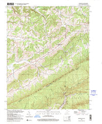
(6)- 1998 Map of Eggleston, 2000 Print
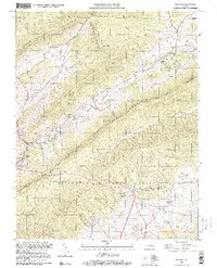
 1998 Eggleston2000 Print · USGSNear the turn of the millennium, this portion of Giles County shows a landscape of mountain ridges and river settlements. Genealogists and historians can trace family sites at Goodwins Ferry, Hoges Chapel, and the Lucas Memorial Cem Ch.
 - 1998 Map of Radford North, 2000 Print
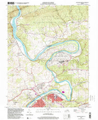 1998 Radford North2000 Print · USGSThe New River valley and Radford area are shown here as they appeared in the late twentieth century, balancing industrial operations with quiet mountain settlements. Researchers can trace the sprawling Radford Army Ammunition Plant or locate genealogy sites like Wake Forest Sch and Morgans Chapel.
 - 1998 Map of Newport, 2000 Print
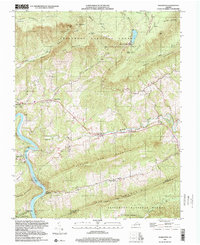
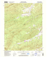
 1998 Newport2000 Print · USGSThe Appalachian highlands of Montgomery and Giles counties are shown in the late 1990s as the mountains remained a stronghold of rural tradition and national forest land. Genealogists and local historians can locate the historic Covered Bridge, numerous family burial sites like Williams Cemetery, and old country churches including Clover Hollow Church.
 - 1998 Map of Narrows, 2000 Print
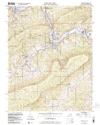 1998 Narrows2000 Print · USGSThe New River valley and the West Virginia border come into focus in the late 1990s as the river flows through the Jefferson National Forest. Genealogists and hikers can trace the Appalachian Scenic Trail past Angels Rest or locate family sites like Woolwine Cem and Cedar Grove Ch.
 - 1998 Map of Lindside, 2001 Print
 1998 Lindside2001 Print · USGSMonroe County and Giles County meet along the high ridges of the Appalachian border in the late nineties. Researchers can trace rural lineages through the Karnes Cem, Kimballton Sch, and the winding path of the Appalachian Trail across Peters Mountain.
 - 1998 Map of Waiteville, 2001 Print
 1998 Waiteville2001 Print · USGSSpanning the West Virginia and Virginia border in the late nineties, this survey captures the high-country landscape of the Jefferson National Forest. Researchers can trace historic transit and family roots through the Old Railroad Grade, the New Zion Union Ch, and the settlement of Waiteville.
End of results
Showing maps 1-6 of 6
Top cities of Giles County
- Pearisburg historical maps
- Narrows historical maps
- Pembroke historical maps
- Rich Creek historical maps
- Ripplemead historical maps
- Glen Lyn historical maps
See more
Frequently asked questions
- What are the different types of historical maps available for Giles County?
- What is the oldest map of Giles County?
- Where can I purchase historical maps of Giles County for my home or office?
- Where can I download high-res historical maps of Giles County?
- Are there historical topographic maps available for Giles County?
- Is there historical aerial imagery available for Giles County?
- Where are historical maps of Giles County sourced from?