1960s Maps of Gloucester County, Virginia
Explore 13 historic maps of Gloucester County from the 1960s. These maps offer a rare glimpse into what life looked like during the 1960s — showing old roads, neighborhoods, homes, and landmarks that have changed or disappeared over time.
Whether you're researching your family's past, planning a metal detecting trip, or studying how Gloucester County's landscape evolved across the 1960s, these high-resolution maps are a powerful tool for exploring the history of this region.
- Focus on a specific era: All maps on this page are from the 1960s, giving you a focused view of this time period.
- See what’s changed: Compare century-old streets, trails, and buildings to today's modern landscape using overlays and satellite layers.
- Research with precision: Use these maps for genealogy, historical research, land use analysis, or educational projects.
- View, download, or print: Maps are fully viewable online in high resolution, and can be downloaded or printed for your own records.
Start exploring Gloucester County's history through authentic maps from the 1960s. This is your window into the past.
Gloucester County, VA maps
(13)- 1964 Map of Richmond
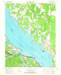
 1964 Richmond1964 Print · USGSCoastal and central Virginia are mapped during the mid-twentieth century, showing the critical intersection of rail, river, and military life. Genealogists can trace family roots through rural county seats like Amelia or find vanished coastal neighborhoods near Phoebus and Hilton Village.
 - 1964 Map of New Point Comfort, 1966 Print
 1964 New Point Comfort1966 Print · USGSThe coastal peninsula of Mathews County comes alive in this mid-century survey of the Chesapeake shoreline. Trace the family landmarks of Potato Neck and discover the location of the New Point Sch and the New Point Comfort Lighthouse.2 unique versions available
 - 1964 Map of Wilton, 1966 Print
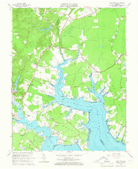
 1964 Wilton1966 Print · USGSThe Virginia Middle Peninsula in the mid-1960s reveals a tidewater landscape of small settlements and riverfront landings. Genealogists and historians can locate rural landmarks such as Old Brick Ch, Stampers Wharf Sch, and Barricks Millpond.4 unique versions available
 - 1965 Map of Ware Neck, 1966 Print
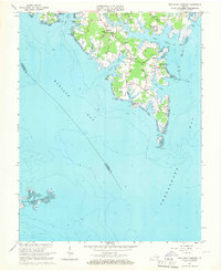
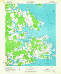
 1965 Ware Neck1966 Print · USGSCoastal Gloucester and Mathews Counties are shown in the mid-1960s, documenting a landscape of tidal necks and maritime landings. Researchers can trace historic river access points and local landmarks like Auburn Wharf, Fort Nonsense, and Baileys Wharf Beacon.4 unique versions available
 - 1965 Map of Shacklefords, 1966 Print
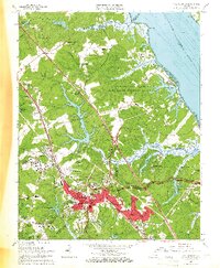
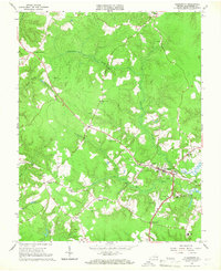
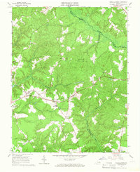 1965 Shacklefords1966 Print · USGSKing and Queen County at the mid-sixties transition is characterized by its deep creek valleys and crossroads communities. Genealogists and local historians can trace legacy sites like York Academy, Hockley Cem, and the historic Poroporone Ch near Shacklefords.4 unique versions available
 - 1965 Map of Gressitt, 1966 Print
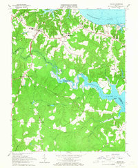
 1965 Gressitt1966 Print · USGSThe Tidewater region of Virginia comes alive in the mid-1960s, showing the complex riverine borders where four counties meet. Genealogists and historians can locate old landings like Croaker Landing and rural centers such as Almondsville and Capahosic.4 unique versions available
 - 1965 Map of Williamsburg, 1966 Print
 1965 Williamsburg1966 Print · USGSWilliamsburg and the Tidewater region are captured here in the mid-sixties, showcasing the historic core alongside burgeoning suburban neighborhoods. Genealogists and historians can trace institutional footprints at the College of William and Mary or find old family sites near Burkes Corner and Magruder Church.4 unique versions available
 - 1965 Map of Achilles, 1967 Print
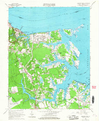
 1965 Achilles1967 Print · USGSCoastal Virginia in the mid-1960s is preserved here as a landscape of tidal creeks and maritime landings. Trace the roots of local families at Roanes Wharf, Achilles, and historic sites like First Morning Star Ch.3 unique versions available
 - 1965 Map of Poquoson West, 1967 Print
 1965 Poquoson West1967 Print · USGSCoastal York County comes alive in the mid-sixties, showing the growth of the Virginia Peninsula alongside its deep military and colonial roots. Genealogists and historians can trace family sites near Grafton-Bethel Sch, Zion Ch, and the National Cem.3 unique versions available
 - 1965 Map of Clay Bank, 1967 Print
 1965 Clay Bank1967 Print · USGSThe York River shoreline in the mid-1960s reveals a landscape of naval installations and deep-rooted Tidewater communities. Genealogists can trace family landmarks like Abingdon Ch, Gloucester Field Cem, and the old settlement at Clay Bank.3 unique versions available
 - 1965 Map of Gloucester, 1967 Print
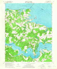
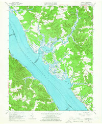
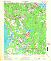
 1965 Gloucester1967 Print · USGSThe Virginia Middle Peninsula in the mid-1960s is shown here as a patchwork of traditional settlements and tidal swamps. Genealogists can trace family roots through numerous local landmarks like Zion Poplars Ch, Botetourt Sch, and the community of Belroi.4 unique versions available
 - 1965 Map of Saluda, 1967 Print
 1965 Saluda1967 Print · USGSMiddlesex and Gloucester counties come to life in the mid-1960s as a landscape of river wharves and rural crossroads. Genealogists and historians can trace family-named landmarks and old congregations from Burhans Wharf to Antioch Church and the campus of Christchurch Sch.6 unique versions available
 - 1965 Map of Yorktown, 1968 Print
 1965 Yorktown1968 Print · USGSCoastal Virginia in the mid-1960s reveals a unique overlap of Revolutionary War history and Cold War military readiness. Researchers can trace ancestral sites from Yorktown to Lee Hall, including the National Cemetery and Rising Sun Church.4 unique versions available
End of results
Showing maps 1-13 of 13
Top cities of Gloucester County
Frequently asked questions
- What are the different types of historical maps available for Gloucester County?
- What is the oldest map of Gloucester County?
- Where can I purchase historical maps of Gloucester County for my home or office?
- Where can I download high-res historical maps of Gloucester County?
- Are there historical topographic maps available for Gloucester County?
- Is there historical aerial imagery available for Gloucester County?
- Where are historical maps of Gloucester County sourced from?