1900s (20th Century) Maps of Troutdale, Virginia
Explore 8 historic maps of Troutdale from the 1900s (20th Century). These maps offer a rare glimpse into what life looked like during the 1900s — showing old roads, neighborhoods, homes, and landmarks that have changed or disappeared over time.
Whether you're researching your family's past, planning a metal detecting trip, or studying how Troutdale's landscape evolved across the 1900s, these high-resolution maps are a powerful tool for exploring the history of this region.
- Focus on a specific era: All maps on this page are from the 1900s, giving you a focused view of this time period.
- See what’s changed: Compare century-old streets, trails, and buildings to today's modern landscape using overlays and satellite layers.
- Research with precision: Use these maps for genealogy, historical research, land use analysis, or educational projects.
- View, download, or print: Maps are fully viewable online in high resolution, and can be downloaded or printed for your own records.
Start exploring Troutdale's history through authentic maps from the 1900s. This is your window into the past.
Troutdale, VA maps
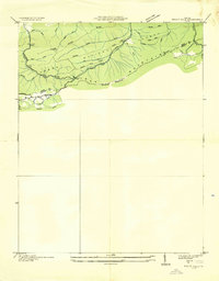
(8)- 1935 Map of Mouth of Wilson
 1935 Mouth of Wilson1935 Print · USGSGrayson County was a landscape of high ridges and river crossings in the mid-1930s. Researchers can trace family sites at Youngs Chapel, find early crossings like Halsey Ferry, and locate old mountain schoolhouses like Oak Hill Sch and Fairwood Sch.
 - 1935 Map of Trout Dale
 1935 Trout Dale1935 Print · USGSGrayson and Smyth Counties are shown in the mid-1930s as a high-altitude landscape of national forest and developing highways. Researchers can trace the early route of the Appalachian Trail and find family-named landmarks like Houndshell Branch and Slabtown Br.
 - 1940 Map of Mouth of Wilson
 1940 Mouth of Wilson1940 Print · USGSGrayson County's high ridges and river valleys were home to a dense network of mountain communities in the 1930s. Genealogists and historians can trace long-gone rural institutions like the COUNTY HOME, Cornell Store, and schools such as Razor Ridge Sch or Bethel Sch.3 unique versions available
 - 1953 Map of Winston-Salem, 1974 Print
 1953 Winston-Salem1974 Print · USGSThe North Carolina Piedmont and Virginia highlands meet in the mid-1950s, a landscape defined by the tobacco and textile hubs of the Blue Ridge foothills. Researchers can trace the rail-and-river geography connecting Winston-Salem to mountain towns like Mount Airy and Galax.2 unique versions available
 - 1955 Map of Winston-Salem
 1955 Winston-Salem1955 Print · USGSThe Central Blue Ridge and Piedmont transition are captured here in the mid-fifties, from the industrial hub of Winston-Salem to the high peaks of Southwest Virginia. Genealogists can trace family landmarks like Richmond Hill Ch, Siloam Ch, and the old rail stops along the Southern Railway.
 - 1959 Map of Trout Dale, 1960 Print
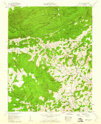 1959 Trout Dale1960 Print · USGSThe high ridges of the Jefferson National Forest are captured here in the late fifties, showcasing mountain life along the Tennessee Divide. Researchers can trace family sites like Blevins Cem, the route of the Appalachian Trail, and remote settlements like Volney and Grant.4 unique versions available
 - 1962 Map of Winston-Salem
 1962 Winston-Salem1962 Print · USGSThe North Carolina Piedmont meets the Virginia highlands in the early sixties, showing the rail corridors and mountain gaps of the southern Appalachians. Researchers can trace the Blue Ridge Parkway or locate family sites near Winston-Salem, Mount Airy, and Hanging Rock Mountain.
 - 1982 Map of Wytheville, 1983 Print
 1982 Wytheville1983 Print · USGSSouthwest Virginia's ridge-and-valley landscape is shown here in the early 1980s as the Interstate era fully connected the region. Genealogists and historians can trace family locations near Emory and Henry College, the historic Austinville Mine, and settlements like Saltville or Lansing.3 unique versions available
End of results
Showing maps 1-8 of 8
Top cities near Troutdale
Frequently asked questions
- What are the different types of historical maps available for Troutdale?
- What is the oldest map of Troutdale?
- Where can I purchase historical maps of Troutdale for my home or office?
- Where can I download high-res historical maps of Troutdale?
- Are there historical topographic maps available for Troutdale?
- Is there historical aerial imagery available for Troutdale?
- Where are historical maps of Troutdale sourced from?